
| Reference: | 40107 |
| Author | Anonimo |
| Year: | 1595 ca. |
| Zone: | Campi Flegrei |
| Printed: | Antwerpen |
| Measures: | 216 x 124 mm |
| Reference: | 40107 |
| Author | Anonimo |
| Year: | 1595 ca. |
| Zone: | Campi Flegrei |
| Printed: | Antwerpen |
| Measures: | 216 x 124 mm |
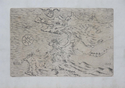
The first printed representation of the sole area of Pozzuoli is the one realized by the heirs of Duchetti, printed in Rome by Ambrogio Brambilla in 1586, though a previous map, which still includes Naples, had been printed in Rome in 1540 circa by the so called “Maestro del trabocchetto”, Nonetheless, Brambilla’s plate is still the real prototype for maps of this area, from which derives the following production, starting with Bertelli in 1599.
Though dated between the end of the XVI and the beginning of the XVII century, this unknown geographic map of the area differs completely from the Duchetti/Brambilla ‘s one, depicting nonetheless some elements that show the author must have known it. The compass rose in the sea is identical, for instance. The map provides but few toponyms, showing some alphabetical reminders as if they were part of an external index. Procida, Vivara and the Eastern coasts of Ischia are depicted. We do suppose the print is Flemish because it was inserted in the same collection of the view on the solfatara already described.
Copper engraving, trimmed to platemark and laid on paper support, in perfect condition. Not listed in catalogues.
|
Cfr. R. Almagià, Studi storici di cartografia napoletana, 104/106; Tooley 460; V. Valerio, E. Bellucci, Piante e vedute di Napoli dal 1486 al 1599, pp.62/63.
|
Anonimo
|
Cfr. R. Almagià, Studi storici di cartografia napoletana, 104/106; Tooley 460; V. Valerio, E. Bellucci, Piante e vedute di Napoli dal 1486 al 1599, pp.62/63.
|
Anonimo