
| Reference: | s28107 |
| Author | Giovanni Antonio MAGINI |
| Year: | 1602 ca. |
| Zone: | Calabria |
| Printed: | Bologna |
| Measures: | - x - mm |
| Reference: | s28107 |
| Author | Giovanni Antonio MAGINI |
| Year: | 1602 ca. |
| Zone: | Calabria |
| Printed: | Bologna |
| Measures: | - x - mm |
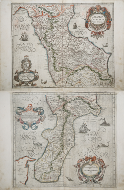
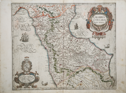
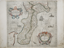
Maps taken from L'Italia edited by Fabio Magini, published in Bologna in 1620, three years after the untimely death of his father.
Composed of a short descriptive text of only 24 pages, the work is accompanied by 61 maps of the peninsula, and is the first example of an Italian atlas. The work is entirely by the hand of Giovanni Antonio Magini, who began the realization of the maps in 1594 or so; the first dated map (1595) the map of the territory of Bologna. All the maps were printed before 1620, in their provisional drafts, later corrected and updated for the final edition. For the realization of the plates Magini used two of the most famous engravers of the time: the Belgian Arnoldo Arnoldi and the English Benjamin Wright.
Copperplate, in good condition.
L’unica carta antecedente a stampa della regione è quella di Prospero Parisio, datata 1589, poi ripresa anche da Ortelius. Nessuna analogia quindi con queste lastre del Magini, che per le nove carte del Regno di Napoli si ispirò al rilievo ufficiale eseguito dallo studioso nolano Niccolò Antonio Stigliola il collaborazione con il cartografo viterbese Mario Cartaro, che tra il 1583 ed il 1594 ebbero l’incarico di realizzare una grande carta del reame. Incise da Benjamin Wright.
La carta della Calabria Citeriore vede nel cartiglio in alto il titolo CALABRIA CITRA, OLIM Magna Graecia. Sotto il cartiglio la scala grafica Scala di Miglia dieci (10 miglia pari a mm 45). Nel cartiglio in basso a sinistra sormontato dal blasone di famiglia la dedica Al Ser.mo mio S.r et P[at]ron[us] Col.mo Il S.r D. Alfonso d’Este Prencip di Modona Regio etc. Fabio di Gio[vanni]Ant.o Magini. sotto il cartiglio Ben. W. F. ( Benjamin Wright). Orientazione nei quattro lati al centro con il nome dei punti cardinali Septentrio, Meridies, Oriens, Occidens, il nord in alto. Graduazione ai margini di 1’ in 1’ da 38° 53’ a 40° 9’ di latitudine, e da 38° 37’ a 40° 36’ 20’’ di longitudine.
La carta della Calabria Ulteriore, ha nel cartiglio in basso a destra il titolo CALABRIA ULTRA olim Altera Magnae Graeciae pars. e la scala grafica Scala di Migligia Venti (20 miglia pari a mm 69); a sinistra nell’angolo le iniziali B. W. (Benjamin Wright). Nel cartiglio in alto a sinistra la dedica Al Molto Ill.re Sig. & P[ad]rone mio Osser.mo Il Sig. Giovanni Angelelli Senatore Bolognese. Questa parte della Magna Grecia, ove fiorì già ogni dottrina, & virtù, et parlossi nella più nobil lingua, cioè nella Greca, a chi meglio si conviene che a V.S. M. Ill.re la quale con la varia erudition sua, et intelligenza d’amendue le lingue Greca e Latina, mirabilmente adorna la nobiltà, e bontà sua singolare. Accettila dunque volentieri, si come io fui già cortesemente accettato da lei tra i più cari suoi servitori. Et perfino le bacio riverentemente le mani. Di Bologna il di primo d’Aprile 1602. Di V.S. Molto Ill.re Ser.re divotiss.mo Fabio di Gio. Antonio Magini. Orientazione nei quattro lati al centro con il nome dei punti cardinali Septentrio, Meridies, Oriens, Occidens, il nord in alto. Graduazione ai margini di 1’ in 1’ da 37° 32’ 20’’ a 39° 13’ 30’’ di latitudine, e da 38° 35’ a 40° 52’ 20’’ di longitudine. Di questa carta è noto anche un esemplare con la dedica firmata da Giovanni Antonio Magini.
Lieve gora nei margini, nel complesso in ottimo stato di conservazione. Dimensioni 420x390 e 455x375 rispettivamente. Le carte del Magini in coloritura coeva sono assolutamente rarissime.
|
I. Principe "Carte geografiche di Calabria nella raccolta Zerbi", pp. 52-53; Almagià (1922) pp. 74/76.
|
Giovanni Antonio MAGINI (1555 - 1617)
|
Giovanni Antonio Magini was born in Padua in 1555, dedicating himself to the study of astronomy from an early age. In 1588 the Senate of Bologna appointed him Lecturer of Astronomy at the local University, choosing him instead of Galileo Galilei. His friendship with the Duke of Mantua, Vincenzo Gonzaga, helped Magini in his quest to obtain cartographical material for map-making from the various sovereigns ruling the different Italian states at that time. Because of Magini's early death in 1617, this effort was made famous by his son Fabio when he published the atlas "L'Italia" in Bologna in 1620. This is the first example of an Italian atlas and is made up of 24 pages of descriptive text and 61 maps of the Italian peninsula. Although this work was published posthumously, it can be entirely ascribed to Magini. He began drawing this maps around 1594, with the one depicting Bologna and its surrounding territories being the first. They were all printed before 1620 in draft editions which were then revised and updated for the final version. These draft proofs are extremely rare, although sometimes available for sale, and exhibit substantial differences in respect to the maps finally included in the atlas. Two of the most famous engravers of the time, Arnoldo Arnoldi and the englishman Benjamin Wright, were entrusted by Magini to engrave the plates. As we shall see in the presentation of the separate maps, they derive from different sources, both known and unknown, and therefore represent the result of an original work of critical analysis and compilation. This atlas had an important influence on the cartography of the italian peninsula for the following two centuries, beginning from Ortelius and going on to the principal dutch cartographers and editors.
|
|
I. Principe "Carte geografiche di Calabria nella raccolta Zerbi", pp. 52-53; Almagià (1922) pp. 74/76.
|
Giovanni Antonio MAGINI (1555 - 1617)
|
Giovanni Antonio Magini was born in Padua in 1555, dedicating himself to the study of astronomy from an early age. In 1588 the Senate of Bologna appointed him Lecturer of Astronomy at the local University, choosing him instead of Galileo Galilei. His friendship with the Duke of Mantua, Vincenzo Gonzaga, helped Magini in his quest to obtain cartographical material for map-making from the various sovereigns ruling the different Italian states at that time. Because of Magini's early death in 1617, this effort was made famous by his son Fabio when he published the atlas "L'Italia" in Bologna in 1620. This is the first example of an Italian atlas and is made up of 24 pages of descriptive text and 61 maps of the Italian peninsula. Although this work was published posthumously, it can be entirely ascribed to Magini. He began drawing this maps around 1594, with the one depicting Bologna and its surrounding territories being the first. They were all printed before 1620 in draft editions which were then revised and updated for the final version. These draft proofs are extremely rare, although sometimes available for sale, and exhibit substantial differences in respect to the maps finally included in the atlas. Two of the most famous engravers of the time, Arnoldo Arnoldi and the englishman Benjamin Wright, were entrusted by Magini to engrave the plates. As we shall see in the presentation of the separate maps, they derive from different sources, both known and unknown, and therefore represent the result of an original work of critical analysis and compilation. This atlas had an important influence on the cartography of the italian peninsula for the following two centuries, beginning from Ortelius and going on to the principal dutch cartographers and editors.
|