| Reference: | S42886 |
| Author | Benedetto MARZOLLA |
| Year: | 1832 |
| Zone: | Calabria |
| Measures: | 560 x 415 mm |
| Reference: | S42886 |
| Author | Benedetto MARZOLLA |
| Year: | 1832 |
| Zone: | Calabria |
| Measures: | 560 x 415 mm |
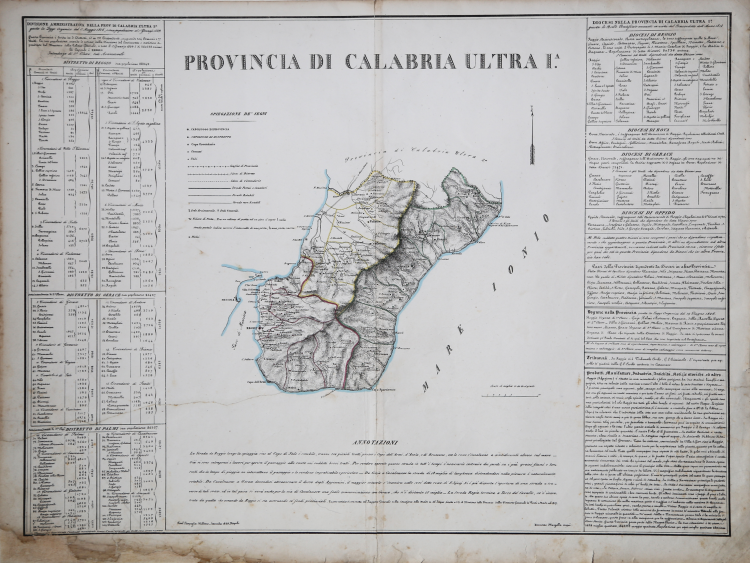
Carta tratta dall’Atlante corografico, storico e statistico del Regno delle Due Sicilie. Napoli: Reale Litografia, 1832.
Benedetto Marzolla fu disegnatore topografo e litografo; geografo e cartografo; membro della Commissione di statistica presso il Ministero dell'Interno. Personaggio di grandissimo rilievo nella cartografia napoletana ed italiana del XIX secolo, Marzolla ottenne in vita pubblici riconoscimenti ed attestati per la produzione cartografica di altissima qualità. La sua notorietà si è lentamente dissolta dopo la morte; va tuttavia osservato che solo la mancanza di uno spiccato coinvolgimento politico in senso risorgimentale e di una valenza letteraria nella sua opera non lo hanno reso famoso come i contemporanei Francesco Costantino Marmocchi (1805-1858) e Attilio Zuccagni-Orlandini (1783-1872), con i quali può certamente confrontarsi. I progetti culturali didattici e editoriali di Marzolla furono e rimangono di straordinaria modernità; egli inventò, è il caso di dire, un nuovo modo di intendere e di disegnare la carta geografica, fornendo una visione assolutamente originale della comunicazione dei dati geografici attraverso la combinazione di testo e immagine. Con tale operazione, egli riuscì a fondere in un'unica opera, storia, geografia, economia, statistica e cartografia, raggiungendo un equilibrio grafico di rara efficacia (cfr. V. Valerio, Benedetto Marzolla Brindisino, Geografo e Cartografo dell'800 Europeo, Brindisi 2008).
Litografia, coloritura coeva dei contorni, restauro conservativo nella parte inferiore destra, per il resto in buono stato di conservazione.
Bibliografia
Valerio, Benedetto Marzolla. Brindisino, Geografo e Cartografo dell’800 Europeo.
Benedetto MARZOLLA (Brindisi, 1801 - Napoli, 1858)
|
Designer surveyor and lithographer, and cartographer, geographer and member of the Commission of Statistics, Ministry of Interior. Character of great importance in the Neapolitan and Italian maps of the nineteenth century, Marzolla won awards and certificates in public life for the cartographic production of high quality. His reputation has slowly dissolved after death, it should be observed that only the lack of a strong political involvement in the Risorgimento and the sense of literary value in his work not made him famous contemporaries such as Francesco Costantino Marmocchi (1805-1858) and Attilio Zuccagni Orlandini (1783-1872), with which it can certainly deal with. Cultural projects and educational publishing Marzolla were and remain extraordinary modernity, he invented, it is appropriate to say, a new way of understanding and to draw the map, providing a totally original data communication through a combination of geographic text and image. With this, he managed to merge into a single work, history, geography, economics, statistics and maps, reaching an equilibrium graph with outstanding performance.
(Cfr. by V. Valerio, Benedetto Marzolla Brindisi,Geografo e Cartografo dell' 800 Europeo, Brindisi 2008)
|