
| Reference: | S49238.98 |
| Author | Georg BRAUN & Franz HOGENBERG |
| Year: | 1572 ca. |
| Zone: | Prague, Cheb |
| Printed: | Antwerpen & Cologne |
| Measures: | 475 x 335 mm |
| Reference: | S49238.98 |
| Author | Georg BRAUN & Franz HOGENBERG |
| Year: | 1572 ca. |
| Zone: | Prague, Cheb |
| Printed: | Antwerpen & Cologne |
| Measures: | 475 x 335 mm |
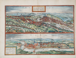
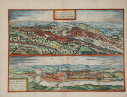
Two bird eye views of Prague and Cheb (Bohemia), first published in the fifth volume of Civitates Orbis Terrarum, edited in 1572.
This view of the city from the north shows on the right the Hradcany castle with - rather cramped beneath it - the Lesser Quarter (Mala Strana), from where the Charles bridge leads into the Old Town. The Lesser Quarter was charted as an independent town in 1257, the old town having already received its own, separate charter in 1230. The Gothic Teyn church with its two towers can be seen on the left, directly above the bend in the Vltava River. Nearby stands the town hall, with Prague's famous astronomical clock, the Orloj. The clock was first installed in a simple form in 1410, making it the third-oldest astronomical clock in the world. The present plate offers a detailed view from the south of the all-dominating Hradcany. The wide steps that formerly led from St Matthew's gate up to the fortress complex can be seen on the left. Towering above its surroundings in the centre is St Vitus's cathedral, which was begun in 1344 and houses the tombs of Charles IV and his son Wenceslas IV. Further right lies the twin-tower Romanesque church of St George, directly attached to St George's monastery from the mid-12th century. On the far right is the Black Tower.
The Civitates Orbis Terrarum, is the first six-volume atlas devoted to town views and plans ever published.
The first volume of the Civitates Orbis Terrarum was published in Cologne in 1572. The sixth and the final volume appeared in 1617. This great city atlas, edited by Georg Braun and largely engraved by Franz Hogenberg, eventually contained 546 prospects, bird-eye views and map views of cities from all over the world. Fransz Hogenberg produced the plates for the first four books, and Simon van den Neuwel (Novellanus, active since 1580) those for volumes V and VI.
Georg Braun (1541-1622), a cleric of Cologne, was the principal editor of the work, and was greatly assisted in his project by the close, and continued interest of Abraham Ortelius, whose Theatrum Orbis Terrarum of 1570 was, as a systematic and comprehensive collection of maps of uniform style, the first true atlas. The Civitates, indeed, was intended as a companion for the Theatrum, as indicated by the similarity in the titles and by contemporary references regarding the complementary nature of two works. Nevertheless, the Civitates was designs to be more popular in approach, no doubt because the novelty of a collection of city plans and views represented a more hazardous commercial undertaking than a world atlas, for which there had been a number of successful precedents. Franz Hogenberg (1535-1590) was the son of a Munich engraves who settled in Malines. He engraved most of the plates for Ortelius's Theatrum and the majority of those in the Civitates and may have been responsible for originating the project.
Over a hundred different artists and cartographers, the most significant of whom was Antwerp artist Georg Hoefnagel (1542-1600), engraved the cooper-plates of the Civitates from drawings. He not only contributed most of the original material for the Spanish and Italian towns but also reworked and modified those of other contributors. After Hoefnagel's death his son Jakob continued the work for the Civitates.
The author set out to depict "non icones et typi urbium," that is, not generic and typified images, "sed urbes ipsae admirabili caelaturae artificio, spectantium oculis subiectae appareant": not intended to allude or idealize but to represent faithfully on paper, to reproduce exactly, and in real time, what the eye sees, as announced in the preface to the first volume of Civitates Orbis Terrarum.
Engraving with fine hand colour, in very good condition.
Bibliografia
Van der Krogt 4, 4659; Fauser, 4659; Taschen, Braun and Hogenberg, p.256.
|
George Braun (1541-1622), cleric of Cologne, was the principal editor of the Civitates Orbis Terrarum, and was greatly assisted in his project by the close, and continued interest of Abraham Ortelius, whose Theatrum Orbis Terrarum of 1570 was, as a systematic and comprehensive collection of maps of uniform style, the first true atlas.
Franz Hogenberg (1535-1590) was the son of a Munich engraves who settled in Malines. He engraved most of the plates for Ortelius's Theatrum and the majority of those in the Civitates, and may have been responsible for originating the project.
|
|
George Braun (1541-1622), cleric of Cologne, was the principal editor of the Civitates Orbis Terrarum, and was greatly assisted in his project by the close, and continued interest of Abraham Ortelius, whose Theatrum Orbis Terrarum of 1570 was, as a systematic and comprehensive collection of maps of uniform style, the first true atlas.
Franz Hogenberg (1535-1590) was the son of a Munich engraves who settled in Malines. He engraved most of the plates for Ortelius's Theatrum and the majority of those in the Civitates, and may have been responsible for originating the project.
|