| Reference: | s34957 |
| Author | Henrick SCHERER |
| Year: | 1700 |
| Zone: | Africa |
| Printed: | Munich |
| Measures: | 357 x 232 mm |
| Reference: | s34957 |
| Author | Henrick SCHERER |
| Year: | 1700 |
| Zone: | Africa |
| Printed: | Munich |
| Measures: | 357 x 232 mm |
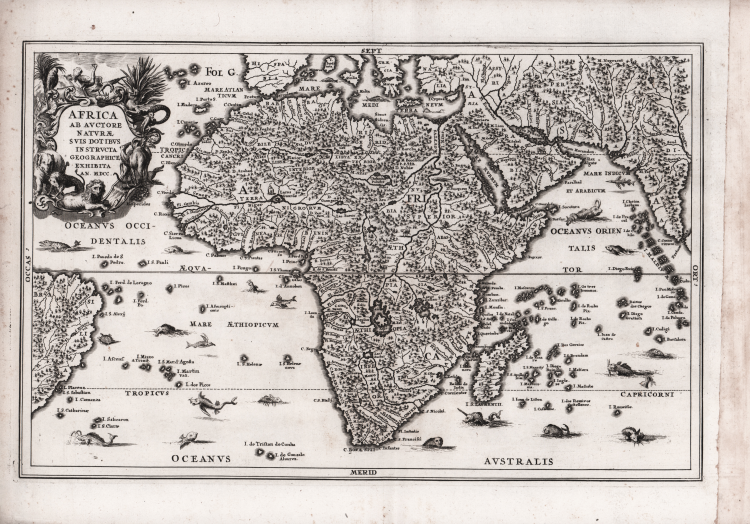
Interesting map of Africa; the continent is presented with a fairly accurate coastline, but most of the interior is entirely fictional. The Nile is shown in the traditional manner with its source in the large southern lakes of Zaflan and Zembre.
The Zembre, also labeled Lac Zaire spawns the Congo and Zaire Rivers as well. The seas abound with a variety of fascinating sea monsters, one of which has a human face, and wild animals roam the interior. The title cartouche is surrounded by detailed engravings of the indigenous animals of Africa. Dated 1700, but published in 1710.
Decorative map by Heinrich Scherer for his Atlas Novus exhibens orbem terraguem per naturae opera, historiae navae acveterus monumenta, artistique geographicae leges et praecepta...published in eight volumes from 1702-1710 in Munich. Scherer, a devout Jesuit, produced this geographical compendium to depict the Catholic hierarchy and the spread of Jesuit missions throughout the world.
Copper engraving, in very good condition.
|
Norwich #62.
|
Henrick SCHERER (Dilingen 1628 - Monaco 1704)
|
Heinrich Scherer was a devout Jesuit, and professor of mathematics at Munich. His 'Atlas Novus' contained maps of all other parts which showed the spread of Catholicism and Jesuit missions.
|
|
Norwich #62.
|
Henrick SCHERER (Dilingen 1628 - Monaco 1704)
|
Heinrich Scherer was a devout Jesuit, and professor of mathematics at Munich. His 'Atlas Novus' contained maps of all other parts which showed the spread of Catholicism and Jesuit missions.
|