| Reference: | CO-838 |
| Author | Zacharias Chatelain |
| Year: | 1759 |
| Zone: | Talamone |
| Printed: | Amsterdam |
| Measures: | 315 x 215 mm |
| Reference: | CO-838 |
| Author | Zacharias Chatelain |
| Year: | 1759 |
| Zone: | Talamone |
| Printed: | Amsterdam |
| Measures: | 315 x 215 mm |
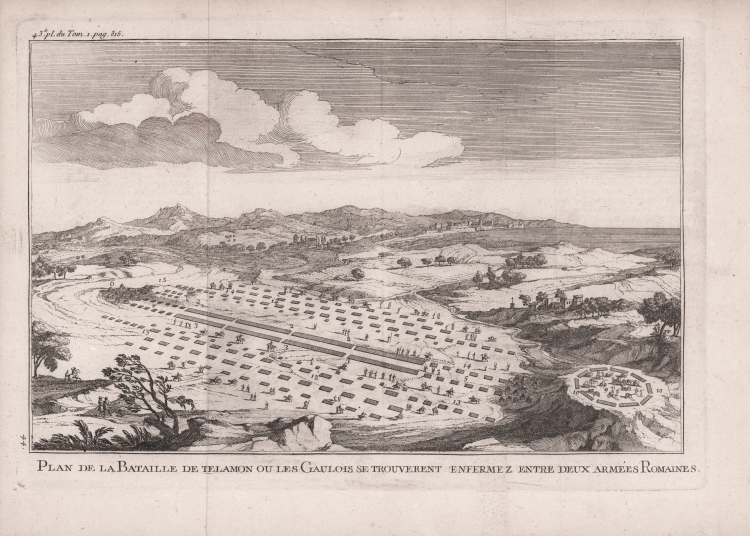
La tavola raffigura la celebre battaglia tra Romani e Celti nei pressi di Talamone.
La tavola è tratta dal quarto tomo del Histoire de Polybe di Vincent Thuillier e Jean Charles de Folard (1669-1752), stampata ad Amsterdam, Zacharie Chatelain, 1759.
Rara e ricercata edizione delle storie di Polibio tradotte in francese dal benedettino Vincent Thuillier, con il testo riveduto e le note di Folard. Opera profusamente illustrata, e dedicata a Federico di Prussia.
La battaglia di Talamone fu combattuta nel 225 a.C. dai Romani e da un'alleanza di popolazioni celtiche nei pressi di Talamone, in località Campo Regio, oggi situata nelle immediate vicinanze della frazione di Fonteblanda.
Acquaforte, in ottimo stato di conservazione.
Zacharias Chatelain (1690-1754)
|
Zacharias was the young brother of the well known Henri Abraham Chatelain (1684 - 1743), a Huguenot pastor of Parisian origins. He is best known as a Dutch cartographer and more specifically for his cartographic contribution in the seminal seven volume Atlas Historique, published in Amsterdam between 1705 and 1720. Innovative for its time, the Atlas Historique combined fine engraving and artwork with scholarly studies of geography, history, ethnology, heraldry, and cosmography. Some scholarship suggests that the Atlas Historique was not exclusively compiled by Henri Chatelain, as is commonly believed, but rather was a family enterprise involving Henri, his father Zacharie and his brother, also Zacharie.
|