| Reference: | S44869 |
| Author | Admiralty Chart |
| Year: | 1872 ca. |
| Zone: | Agrigento, Catania |
| Printed: | London |
| Measures: | 670 x 515 mm |
| Reference: | S44869 |
| Author | Admiralty Chart |
| Year: | 1872 ca. |
| Zone: | Agrigento, Catania |
| Printed: | London |
| Measures: | 670 x 515 mm |
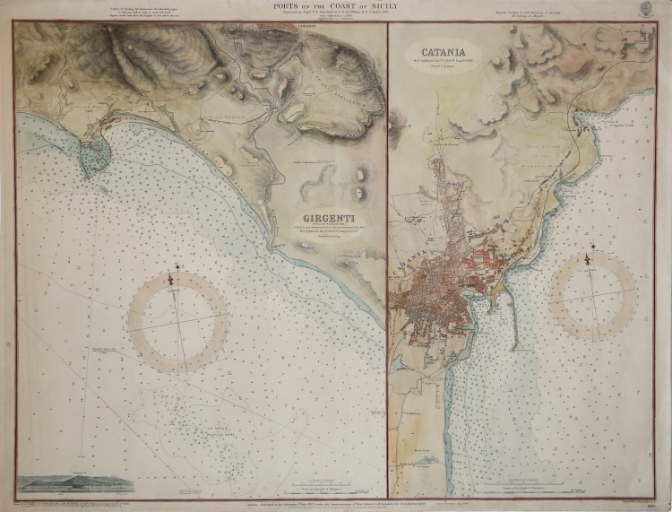
Pair of nautical charts on one sheet: on the left is a chart focusing on the area of Agrigento, with the nearby Port Empedocle, for which a nautical plan is provided with the draft of the docks. On the right are depicted the surroundings of Catania, with an accurate description of the plan of the city and its port, of which docks and depths are described. In the sea bathymetric lines and a wind rose.
Printed in 1872, this map is the 1884 update.
Admiralty charts are nautical charts issued by the United Kingdom Hydrographic Office and subject to Crown Copyright. Over 3,000 charts are available and cover virtually the entire world in various levels of detail depending on the density of traffic and hazards. Large-scale charts often cover approaches and entrances to harbours, medium-scale charts cover heavily used coastal areas, and small-scale charts are for navigation in more open areas. There is also a Small Crafts Series available at even smaller scales. The United Kingdom Hydrographic Office (or UKHO) is an organisation within the UK government responsible for providing navigational and other hydrographic information for national, civil and defence requirements. The Admiralty's first Hydrographer was Alexander Dalrymple, appointed in 1795 on the order of King George III and in the next year the existing charts were brought together and catalogued. The first chart the Admiralty produced (of Quiberon Bay in Brittany) did not appear until 1800.
|
|
Admiralty charts are nautical charts issued by the United Kingdom Hydrographic Office and subject to Crown Copyright. Over 3,000 charts are available and cover virtually the entire world in various levels of detail depending on the density of traffic and hazards. Large-scale charts often cover approaches and entrances to harbours, medium-scale charts cover heavily used coastal areas, and small-scale charts are for navigation in more open areas. There is also a Small Crafts Series available at even smaller scales. The United Kingdom Hydrographic Office (or UKHO) is an organisation within the UK government responsible for providing navigational and other hydrographic information for national, civil and defence requirements. The Admiralty's first Hydrographer was Alexander Dalrymple, appointed in 1795 on the order of King George III and in the next year the existing charts were brought together and catalogued. The first chart the Admiralty produced (of Quiberon Bay in Brittany) did not appear until 1800.
|