| Reference: | S38951 |
| Author | Johannes JANSSONIUS |
| Year: | 1628 ca. |
| Zone: | Treviso |
| Printed: | Amsterdam |
| Measures: | 190 x 138 mm |
| Reference: | S38951 |
| Author | Johannes JANSSONIUS |
| Year: | 1628 ca. |
| Zone: | Treviso |
| Printed: | Amsterdam |
| Measures: | 190 x 138 mm |
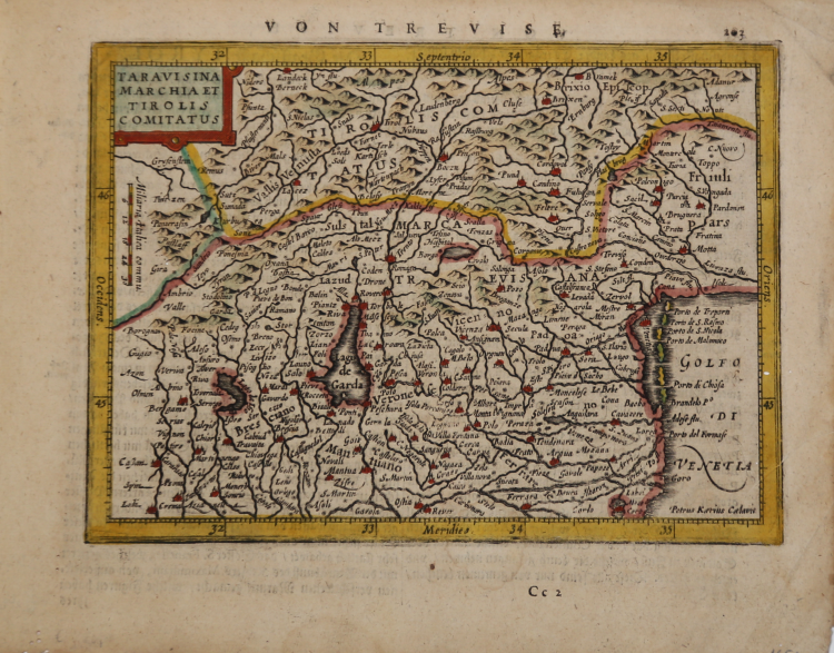
An attractive map of the Italian Tyrol, including Lake Garda, Brescia, Verona and the district of Venice. In 1607 Jodocus Hondius published a reduced size version of Gerhard Mercator's renowned "Atlas", itself suitably titled "Atlas Minor".
The maps were copied from those of the great cartographer Mercator of around 1580-90 or were reductions of Hondius' own maps of 1606. The popularity of the smaller format and reduced price, compared with the folio issues of "Atlas", was reflected in the many subsequent editions and in the variety of derivative publications in similar style. Almost 20 years later the map and atlas publisher Joannes Janssonius commissioned a new set of copperplates to be engraved by Pieter Van Den Keere (often signed Kaerius) and Abraham Goos, two of the most proficient and experienced Dutch map engravers of the period. These maps were elegantly designed with decorative title cartouches, finely engraved and surprisingly detailed, elements particularly noticeable in their early printings, as here.
|
Koeman, Atlantes Neerlandici, Me 194.
|
Johannes JANSSONIUS (1588-1664)
|
Johannes Janssonius, more commonly known to us as Jan Jansson, was born in Arnhem where his father was a bookseller and publisher (Jan Janszoon the Elder). In 1612 he married the daughter of the cartographer and publisher Jodocus Hondius, and then set up in business in Amsterdam as a book publisher. In 1616 he published his first maps of France and Italy and from then onwards he produced a very large number of maps, perhaps not quite rivalling those of the Blaeu family but running a very close second in quantity and quality. From about 1630 to 1638 he was in partnership with his brother-in-law, Henricus Hondius, issuing further editions of the Mercator/Hondius atlases to which his name was added. On the death of Henricus he took over the business, expanding the atlas still further, until eventually he published an 11-volume Atlas Major on a scale similar to Blaeu's Atlas Major.
The first full edition of Jansson's English County Maps was published in 1646 but some years earlier he issued a number of British maps in the Mercator/Hondius/Jansson series of atlases (1636-44); the maps were printed from newly engraved plates and are different from the later 1646 issue and are now rarely seen (see Appendix B for further details).
In general appearance Jansson's maps are very similar to those of Blaeu and, in fact, were often copied from them, but they tend to be more flamboyant and, some think, more decorative.
After Jansson's death his heirs published a number of maps in an Atlas Contractus in 1666 and later still many of the plates of his British maps were acquired by Pieter Schenk and Gerard Valck, who published them again in 1683 as separate maps.
|
|
Koeman, Atlantes Neerlandici, Me 194.
|
Johannes JANSSONIUS (1588-1664)
|
Johannes Janssonius, more commonly known to us as Jan Jansson, was born in Arnhem where his father was a bookseller and publisher (Jan Janszoon the Elder). In 1612 he married the daughter of the cartographer and publisher Jodocus Hondius, and then set up in business in Amsterdam as a book publisher. In 1616 he published his first maps of France and Italy and from then onwards he produced a very large number of maps, perhaps not quite rivalling those of the Blaeu family but running a very close second in quantity and quality. From about 1630 to 1638 he was in partnership with his brother-in-law, Henricus Hondius, issuing further editions of the Mercator/Hondius atlases to which his name was added. On the death of Henricus he took over the business, expanding the atlas still further, until eventually he published an 11-volume Atlas Major on a scale similar to Blaeu's Atlas Major.
The first full edition of Jansson's English County Maps was published in 1646 but some years earlier he issued a number of British maps in the Mercator/Hondius/Jansson series of atlases (1636-44); the maps were printed from newly engraved plates and are different from the later 1646 issue and are now rarely seen (see Appendix B for further details).
In general appearance Jansson's maps are very similar to those of Blaeu and, in fact, were often copied from them, but they tend to be more flamboyant and, some think, more decorative.
After Jansson's death his heirs published a number of maps in an Atlas Contractus in 1666 and later still many of the plates of his British maps were acquired by Pieter Schenk and Gerard Valck, who published them again in 1683 as separate maps.
|