| Reference: | S13573 |
| Author | Nicolas DE FER |
| Year: | 1695 ca. |
| Zone: | Livorno |
| Printed: | Paris |
| Measures: | 219 x 180 mm |
| Reference: | S13573 |
| Author | Nicolas DE FER |
| Year: | 1695 ca. |
| Zone: | Livorno |
| Printed: | Paris |
| Measures: | 219 x 180 mm |
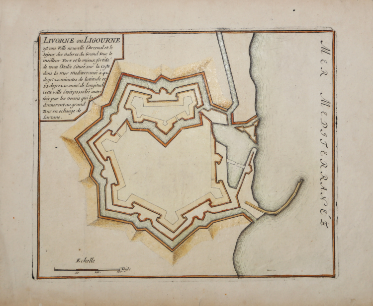
Pianta della città fortificata tratta dal Les forces de l’Europe ou description des principals villes…Paris: Chez l'Auteur, 1693-1696.
Noto atlante militare francese, anche se, prevalentemente, si tratta di mappe, piani e vedute di fortificazioni di città europee in Francia, Germania e Paesi Bassi, l'atlante include anche una serie di altre regioni, tra cui Malta, Costantinopoli, Tripoli e altrove.
Nicholas de Fer (1646-1720) era figlio di un venditore di mappe, Antoine de Fer, e divenne uno dei cartografi più noti della Francia del XVII secolo. A dodici anni fu apprendista presso l'incisore Louis Spirinx. Quando il padre morì nel 1673, Nicholas aiutò la madre a gestire l'attività fino al 1687, quando divenne l'unico proprietario. Nel 1697 pubblicò il suo primo atlante mondiale. Dopo la sua morte, avvenuta nel 1720, l'attività passò ai suoi generi, Guillaume Danet e Jacques-Francois Benard.
Incisione in rame, in buono stato di conservazione.
Nicolas DE FER (1646-1720 circa)
|
One of the most prolific and influential French geographers and cartographers of the late 17th and early 18th Century. Nicolas was the youngest son of Parisian print and mapseller, Antoine de Fer [d.1673]. He produced numerous atlases: Atlas Curieux [1700-5] and its subsequent suites; Atlas ou Receuil des Cartes [1709]; Atlas Royale [1699]; Les Beautés de la France [1708]; Atlases detailing wars and countries relating to the Spanish succession [1701]; Italy [1702] & Germany [1705] and Franco-Belgian frontiers [1708-10]; Les Forces de L'Europe [1690-95]; Introduction à la Géographie [1708]; the Petit Nouveau Atlas [1697]. Aswell as his Atlas output de Fer is also well known for his large Wall maps, some 26 in total, aswell as large-scale town plans of European cities, and a signifcant output of thematic printed card games. His sign and emblem was the Sphère Royale, originally that of Melchior Tavernier, to which he was greatly attached and which appears on a large number of his works. He died on 25th October 1720 and his estate was divided between his three daughters, all three of whose husbands were closely involved in the Parisian engraving and publishing business : Guillaume Danet, Remi Richer, Jaques-Francois Besnard or Bénard. A number of de Fer's maps and atlases continued to be published by his heirs for another twenty or thirty years.
|