| Reference: | S299560 |
| Author | Johannes VAN KEULEN |
| Year: | 1683 ca. |
| Zone: | Corsica |
| Printed: | Amsterdam |
| Measures: | 500 x 290 mm |
| Reference: | S299560 |
| Author | Johannes VAN KEULEN |
| Year: | 1683 ca. |
| Zone: | Corsica |
| Printed: | Amsterdam |
| Measures: | 500 x 290 mm |
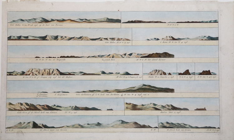
Coastlines relating to the Ile de Hyeres and Corsica taken from the late 1781 edition of Zee-Fakkel by the Van Keulen family. The van Keulen Publishing House was founded around 1678 by the founder Johannes, who was succeeded in 1695 by his son Gerard, versed in nautical disciplines and skilled engraver, who gave the company the cartographic specialization that made it famous in Holland and Europe for two centuries to follow.
The editorial production included a large portfolio of manuscript loose charts, a nautical atlas called Le Grand Nouvel Atlas de la Mer and the monumental De Nieuwe Groote Lichtende Zee-Fakkel, or a pilot book of the seas of the world published between 1681 and 1684 in five volumes in folio, to which - in 1753 - was added a sixth for navigation along the coasts of Asia.
According to an editorial formulation consolidated since the Spieghel der Zeewaerdt of L. J. Waghenaer, the first volume describes the northern seas from Holland to the Hudson Strait, while the second volume is devoted to navigation from the North Sea to the continental European coasts to the Cape Verde Islands. The third volume describes the Mediterranean, which was particularly important as a “crossroads” of trade between East and West. The fourth volume covers the West Indies and the eastern coasts of North America, while the fifth contains maps of West Africa to the Cape of Good Hope and eleven maps of Brazil, as well as some maps of the Far East that prelude to the compilation of the sixth volume. The Asian coasts were, in fact, of pre-eminent interest to Holland, which had founded a commercial empire, and then the cards of those regions remained for a long time manuscript, so that it was prevented from spreading outside the fleet of the VOC, until 1753, when by then were already several decades in circulation nautical atlases published by the British and French.
The Nieuwe Groote Lichtende Zee-Fakkel, which included nautical instructions, general and detailed charts, plans of ports and coastal views, was translated into several languages and printed in several editions.
The third book, dedicated to the Mediterranean, had an Italian edition, published in 1695 with the title Della nuova grande illuminante face del mare and reprinted in 1705. As the extensor of the text is N. J. Vooght, while the Italian translation is the Paduan Moses Giron. Several papers bear dates subsequent to the publication of the pilot book, because while the text did not require updates, the cards were replaced over time as needed.
Copperplate, finely colored by hand, in excellent condition.
Bibliografia
C. Koeman, Atlantes Neerlandici: Bibliography of Terrestrial, Maritime and Celestial Atlases and Pilot Books Published in the Netherlands up to 1880 Vol. IV, Amsterdam 1970, pp. 338-347, Keu 87 A (1) 99; National Maritime Museum, Catalogue of the Library - Vol. Three, Atlas & Cartography, Londra, 1971, pp. 110-114, n. 107 (104); cfr. R. Shirley, Maps in the Atlases of the British Library, Londra, 2004, pp. 1200-1213; cfr. D. de Vries, G. Schilder, W. Morzer Bruyns, P. van Iterson, I. Jacobs, The Van Keulen Cartography Amsterdam 1680-1885, Alphen aan den Rijn, 2005.
Johannes VAN KEULEN (1654 - 1715)
|
The Van Keulen dynasty of publishers, printers, booksellers, and cartographers produced the most comprehensive and up-to-date Dutch nautical atlases. Johannes van Keulen (1654–1715) founded a book and instrument business in Amsterdam in 1678 and in 1680 obtained the privilege of printing nautical guides and atlases from Holland and West Friesland. His first major work was the Nieuwe Lichtende Zee-Fakkel, illustrated by Jan Luyken, with maps drawn by Claes Jansz Vooght; five volumes were published between 1681 and 1684. Van Keulen also produced a Zee-Atlas ofte Water-werelt. The Van Keulen family continued to operate for nearly two centuries; Gerard (1678 - 1726) produced new editions of his father's works, numerous manuscript maps, and was appointed hydrographer to the Dutch East India Company (VOC) in 1706; his son Jan II van Keulen (1704 - 1770) took over the business in 1726 and published a new edition of the Asiatic volume of the Zee-Atlas; he was appointed cartographer to the VOC in 1743. After Jan II's death, his sons Cornelis Buijs and Gerard Hulst van Keulen ran the family business. Gerard (1733 - 1801) added a further volume to the Zee-Fakkel containing East India material derived from the VOC. Gerard, in addition to publishing the first nautical almanac in Dutch in 1788, was one of the three original members of the commission established by the Dutch government in 1787 to solve the problem of finding longitude at sea. Gerard's son, Jan III, was the last van Keulen to run the company.
|