
| Reference: | S5375 |
| Author | Johannes BLAEU |
| Year: | 1663 ca. |
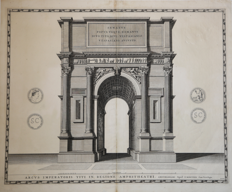
| Zone: | Arco di Tito |
| Printed: | Amsterdam |
| Measures: | 596 x 470 mm |
| Reference: | S5375 |
| Author | Johannes BLAEU |
| Year: | 1663 ca. |
| Zone: | Arco di Tito |
| Printed: | Amsterdam |
| Measures: | 596 x 470 mm |
Bella veduta dell'arco di Tito.
Opera per la prima volta pubblicata nel Theatrum Civitatum et admirandorum Italiae, pubblicato ad Amsterdam nel 1663. Johannes Blaeu, durante la sua lunga attività editoriale pubblica tre volumi sulle città italiane.
Nel 1663 i primi tre comprendevano: Stato della Chiesa, Roma e Regno di Napoli, Sicilia.
Alla sua morte, i suoi eredi danno alla luce altri due volumi, datati 1682, incentrati sulle città del Piemonte e della Savoia, poi ristampati da altri editori nel 1693 e 1697. Il francese Pierre Mortier pubblica una ristampa nel 1704/5, intitolata Nouveau Theatre de l’Italie. L’opera, in quattro volumi, comprende le lastre del Blaeu, ritoccate e modificate in piccola parte, integrate dall’aggiunta di numerose nuove mappe di proprio disegno, raffiguranti le città della parte settentrionale della penisola, racchiuse nel primo volume dell’opera.
L’atlante del Mortier venne pubblicato con testo latino, francese ed olandese. La particolarità che differenzia le due edizioni di Blaeu e Mortier è rappresentata dal fatto che il testo non è al verso della singola mappa (che quindi è bianca nel retro), ma si trova all’inizio di ogni singolo volume.
Il grande successo dell’opera diede origine ad un’ulteriore ristampa, praticamente identica, curata da R. Alberts ed edita nel 1724/5. Le opere tratte dalla prima edizione del Blaeu, 1663, sono caratterizzate dalla presenza del testo al verso e sono piuttosto rare.
Incisione in rame, in buono stato di conservazione.
Esemplare tratto dal Nouveau Theatre de l'Italie pubblicato ad Amsterdam nel 1704/5 o nel 1724.
|
Koeman pp. 332/338, Cremonini pp. 83-90.
|
Johannes BLAEU (Alkmaar 1596 circa - Amsterdam 1663)
|
Joan Blaeu was the eldest son of Willem Janszoon Blaeu (1571-1638), and was probably born in Alkmaar in the province of Noord-Holland in the final years of the 16th century. He was brought up in Amsterdam, and studied law at the University of Leiden before going into partnership with his father in the 1630s. He became chief cartographer to the Dutch East India Company from 1638, and from 1651 to 1672 he served on the Amsterdam City Council without a break, holding several public offices. He also invested in Dutch colonial interests in North America. Joan Blaeu main work was Theatrum Orbis Terrarum (or Atlas Maior as it had became known.) Atlas had expanded to between 9 and 12 volumes, depending on the language. With over 3,000 text pages and approximately 600 maps, it was the most expensive book money could buy in the later 17th century. In 1638 Willem Blaeu died and the business passed into the hands of his sons, Joan and Cornelis, who continued and expanded their father's ambitious plans. After the death of Cornelis, Joan directed the work alone and the whole series of 6 volumes was eventually completed about 1655. As soon as it was finished he began the preparation of the even larger work, the Atlas Major, which reached publication in 1662 in II volumes (later editions in 9-12 volumes) and contained nearly 6oo double-page maps and 3,000 pages of text. This was, and indeed remains, the most magnificent work of its kind ever produced; perhaps its geographical content was not as up-to-date or as accurate as its author could have wished, but any deficiencies in that direction were more than compensated for by the fine engraving and colouring, the elaborate cartouches and pictorial and heraldic detail and especially the splendid calligraphy. In 1672 a disastrous fire destroyed Blaeu's printing house in the Gravenstraat and a year afterwards Joan Blaeu died. The firm's surviving stocks of plates and maps were gradually dispersed, some of the plates being bought by F. de Wit and Schenk and Valck, before final closure in about 1695.
|
|
Koeman pp. 332/338, Cremonini pp. 83-90.
|
Johannes BLAEU (Alkmaar 1596 circa - Amsterdam 1663)
|
Joan Blaeu was the eldest son of Willem Janszoon Blaeu (1571-1638), and was probably born in Alkmaar in the province of Noord-Holland in the final years of the 16th century. He was brought up in Amsterdam, and studied law at the University of Leiden before going into partnership with his father in the 1630s. He became chief cartographer to the Dutch East India Company from 1638, and from 1651 to 1672 he served on the Amsterdam City Council without a break, holding several public offices. He also invested in Dutch colonial interests in North America. Joan Blaeu main work was Theatrum Orbis Terrarum (or Atlas Maior as it had became known.) Atlas had expanded to between 9 and 12 volumes, depending on the language. With over 3,000 text pages and approximately 600 maps, it was the most expensive book money could buy in the later 17th century. In 1638 Willem Blaeu died and the business passed into the hands of his sons, Joan and Cornelis, who continued and expanded their father's ambitious plans. After the death of Cornelis, Joan directed the work alone and the whole series of 6 volumes was eventually completed about 1655. As soon as it was finished he began the preparation of the even larger work, the Atlas Major, which reached publication in 1662 in II volumes (later editions in 9-12 volumes) and contained nearly 6oo double-page maps and 3,000 pages of text. This was, and indeed remains, the most magnificent work of its kind ever produced; perhaps its geographical content was not as up-to-date or as accurate as its author could have wished, but any deficiencies in that direction were more than compensated for by the fine engraving and colouring, the elaborate cartouches and pictorial and heraldic detail and especially the splendid calligraphy. In 1672 a disastrous fire destroyed Blaeu's printing house in the Gravenstraat and a year afterwards Joan Blaeu died. The firm's surviving stocks of plates and maps were gradually dispersed, some of the plates being bought by F. de Wit and Schenk and Valck, before final closure in about 1695.
|