
| Reference: | S40917 |
| Author | Pietro Zancon |
| Year: | 1794 |
| Zone: | North America |
| Printed: | Venice |
| Measures: | 100 x 70 mm |
| Reference: | S40917 |
| Author | Pietro Zancon |
| Year: | 1794 |
| Zone: | North America |
| Printed: | Venice |
| Measures: | 100 x 70 mm |
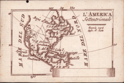
A GREAT RARITY
Unknown small map with imprint by Giacomo Zatta and date 1794, belonging to an undocumented miniature atlas entitled “Atlante tascabile per le dame” (Pocket Atlas for ladies), divided into three volumes, printed "IN VENETIA Presso G. Zatta", undated but about 1795.
A rare set of visiting cards published in Italy features pretty little maps of all parts of the world - with a special white space where to put your name - where the imprint appears or of Pietro Zancon (accompanied by the date 1794) or Giacomo Zatta (with the date 1794 or 1795), who, as can be read on the title page, is the publisher of the whole Atlas. We can speculate that the series, started by Zancon was later terminated by Zatta. On the map of Italy is printed - presumably the first map of the work - the name of Chiara Minelli Rota, Venetian noblewoman who married Antonio Rota in 1794; all remaining 65 maps bear the blank space without names.
Previously, the maps were known only through a series, without editorial imprint, sold 21 years ago (1999) by the Antiquariaat Haas of Bedburg Hau; speaking with Stephan Haas, the series, without title and printing details, consisted of 70 maps. The maps were sold separately under the name of G. Bonatti, the engraver's signature found on the map of France. Later, the plates were attributed to Pietro Zaricen by Geoffrey King (see Miniature Antique Maps, p. 181). The name of Zaricen is derived from the Roussillon county map, which bears the inscription "Venice 1794 App.o P. Zancon", incorrectly read as Zaricen. Lajos Szantai includes the map of Hungary in his cartobibliography, translating the author's name into Zancen (see Atlas Hungaricus 1528-1850). Always King, who does not mention any map signed by Zatta, said: "About the turn of the century a signed card of the first edition, with a map of the province of Roussillon in the south of France, was seen at an Ephemera Society Fair in London ". This copy would seem to be the one preserved in the Yale University Library [call number 1978 351], which describes it as being composed of 70 maps. We do not know if it is the total number of maps, and the absence of an index or list does not allow to establish the exact number of maps.
http://hdl.handle.net/10079/bibid/3611852
Comparing the maps erroneously attributed to Zaricen one realizes that the plate is erased in correspondence with the signature of Zancon or Zatta. There are very little information on the maps, that we can now define as "ex Zaricen". Jason Hubbard in his recent bibliography on the maps of Japan depicts the map without the imprint "App.o G. Zatta" attributing it - on the basis of the bibliographic information so far known - to Giuseppe Bonatti and Pietro Zaricen: “This is one of the 70-odd geographical cards, printed on one side only, acquired by the Haas brothers in 1999. The cards cover countries around the world and include detailed map of Italian provinces. The card with the map of France carries the inscription: G. Bonatti fece; and it is presumed that Bonatti engraved all of them although this is questioned by King” (cf. J. Hubbard, Japoniae Insulae, n. 124).
Our copy of the map of France, which bears the imprint "Venice 1794, App.o P. Zancon", also shows the signature of Bonatti mentioned at the bottom right. Therefore, the only difference between this series of unknown maps seems to be the presence of the addresses of Zancon and Zatta, accompanied by the date 1794 or 1795. Giuseppe Bonatti is mentioned by V. Valerio as an engraver raised at the Remondini school in Bassano, author of some maps for the atlas of Pazzini Carli (Siena, 1788-1800) and for the geographical atlas of Carlo Antonio Barbiellini (Milan, 1807). From 1809 onwards he worked as an engraver for the Milan Deposito della Guerra (see V. Valerio, Cartografi Veneti, p. 153).
Pietro Zancon was, together with the most famous brother Gaetano, a native engraver of Bassano del Grappa, who grew up at the Remondini printing school, such as Bonatti. Giacomo Zatta, was the son or the brother of the most famous typographer, bookseller, publisher Antonio Zatta, who lived in Venice in the second half of the century. XVIII. His workshop devoted himself to the publication of maps and atlases, as well as numerous classics of literature. His most important and best-known work is the "Atlante Novissimo", published in four volumes between 1775 and 1789, with the plates drawn mostly by Giovanni Pitteri and engraved in copper by Giuliano Zuliani. These small geographical maps derive from the maps of the Atlante Novissimo.
Exemple of the very rare first state of two, with the imprint of Giacomo Zatta and the date 1794, unknown to all bibliographies. Etching, printed in red-brown ink on laid paper, perfect condition.
Literature: cf. J. Hubbard, Japoniae Insulae. The Mapping of Japan, Houten, 2012, n. 124; G. King, Miniature Antique Maps, Londra, 2003, p. 181; Lajos Szantai, Atlas Hungaricus 1528-1850. Budapest, Akadmiai Kiado, 1996; cf. V. Valerio, Cartografi Veneti, Padova, 2007, p. 153.
Pietro Zancon
Pietro Zancon