
| Reference: | S38086 |
| Author | Johann Baptist HOMANN |
| Year: | 1716 ca. |
| Zone: | Mexico, Florida |
| Printed: | Nurnberg |
| Measures: | 590 x 490 mm |
| Reference: | S38086 |
| Author | Johann Baptist HOMANN |
| Year: | 1716 ca. |
| Zone: | Mexico, Florida |
| Printed: | Nurnberg |
| Measures: | 590 x 490 mm |
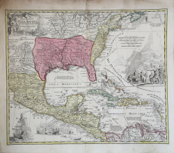
Decorative full color example of this decorative map, which is based upon De L'Isle's landmark map of Mexico and Florida, first issued in 1703.
The map introduces the information from La Salle, Bienville, d'Iberville and other French explorers in America. It was the first map to accurately portray the mouth of the Mississippi and the Great Lakes region. Also accurately shown for the first time are the English settlements on the east coast. The reports of Iberville are present in the villages in the Lower Mississippi Valley and Texas, where the Spanish were active building missions and presidios. Several Dutch and German cartographers copied De L'Isle's work, but added the rich embellishments present in this map.
The tracks of the Spanish Galleons and routes to Havana are shown.
The map was made by Homann for his Grosser Atlas.
Johann Baptist Homann was a German geographer and cartographer; in 1702 he founded his own publishing house. Homann acquired renown as a leading German cartographer, and in 1715 was appointed Imperial Geographer by Emperor Charles VI. In the same year he was also named a member of the Prussian Academy of Sciences in Berlin. In 1716 Homann published his masterpiece Grosser Atlas ueber die ganze Welt; numerous maps were drawn up in cooperation with the engraver Christoph Weigel the Elder. Homann died in Nuremberg in 1724 and was succeeded by his son Johann Christoph (1703-1730). The company carried on upon his death as Homann heirs company, managed by Johann Michael Franz and Johann Georg Ebersberger. After subsequent changes in management the company folded in 1852.
Johann Baptist HOMANN (1663 - 1724)
|
Johann Baptist Homann (20 March 1664 – 1 July 1724) was a German geographer and cartographer
born in Oberkammlach near Kammlach in the Electorate of Bavaria. Although educated at a Jesuit school, and preparing for an ecclesiastical career, he eventually converted to Protestantism and from 1687 worked as a civil law notary in Nuremberg. He soon turned to engraving and cartography; in 1702 he founded his own publishing house. Homann acquired renown as a leading German cartographer, and in 1715 was appointed Imperial Geographer by Emperor Charles VI. Giving such privileges to individuals was an added right that the Holy Roman Emperor enjoyed. In the same year he was also named a member of the Prussian Academy of Sciences in Berlin. Of particular significance to cartography were the imperial printing privileges (Latin: privilegia impressoria). These protected for a time the authors in all scientific fields such as printers, copper engravers, map makers and publishers. They were also very important as a recommendation for potential customers. In 1716 Homann published his masterpiece Grosser Atlas ueber die ganze Welt (Grand Atlas of all the World). Numerous maps were drawn up in cooperation with the engraver Christoph Weigel the Elder, who also published Siebmachers Wappenbuch. Homann died in Nuremberg in 1724. He was succeeded by his son Johann Christoph (1703-1730). The company carried on upon his death as Homann heirs company, managed by Johann Michael Franz and Johann Georg Ebersberger. After subsequent changes in management the company folded in 1852. The company was known as "Homann Erben", "Homanniani Heredes", or "Heritiers de Homann" abroad.
1702-07 Atlas novus terrarum
1712 Enlarged edition with re-issues to c.1753
c.1714 Neuer Atlas
re-issues to c. 1730
1719 Atlas Methodicus
1730 America Septentrionali Britannorum
1737 Grosser atlas
re-issues to c. 1770
|