| Reference: | S36137 |
| Author | Isaak TIRION |
| Year: | 1765 |
| Zone: | New Mexico, California |
| Printed: | Amsterdam |
| Measures: | 350 x 327 mm |
| Reference: | S36137 |
| Author | Isaak TIRION |
| Year: | 1765 |
| Zone: | New Mexico, California |
| Printed: | Amsterdam |
| Measures: | 350 x 327 mm |
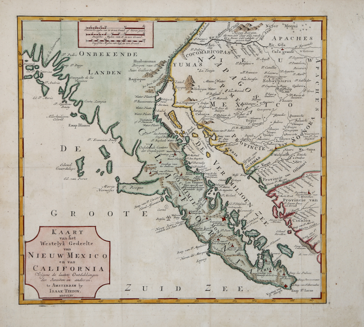
A detailed map of the Baja California and Sonora, bounded on the north by the Colorado and Gila Rivers and approximately Mozatlan in the south, thus including parts of modern Arizona and New Mexico, an area including the modern towns of Yuma, Phoenix and Tucson, while Cape St. Diego is marked at the site of the modern city.
Isaac Tirion's map of Baja California is one of the best mid-18th century maps of Southern California, Baja California and parts of Arizona and Sonora. Issued 4 years prior to the establishment of the first Spanish Mission in Alta California (San Diego) and based in large part on the work of Ferdinando Consag, the map provides one of the earliest large format attempts to map this still mysterious and unsettled region north of Baja California, along with the then Jesuit regions of Baja California and Sonora. The map is one of the last to focus on the region before the expulsion of the Jesuits in 1768.
A fascinating, uncommon, detailed map.
Copperplate with fine later hand colour, very good condition.
Isaak TIRION (1705 ca. - 1765)
|
A successful publisher in Amsterdam, who produced extensive volumes of Dutch town plans as well as a number of atlases with maps usually based on those of G. Delisle.
|
Isaak TIRION (1705 ca. - 1765)
|
A successful publisher in Amsterdam, who produced extensive volumes of Dutch town plans as well as a number of atlases with maps usually based on those of G. Delisle.
|