| Reference: | s34945 |
| Author | Henrick SCHERER |
| Year: | 1699 |
| Zone: | Northern America |
| Printed: | Munich |
| Measures: | 361 x 240 mm |
| Reference: | s34945 |
| Author | Henrick SCHERER |
| Year: | 1699 |
| Zone: | Northern America |
| Printed: | Munich |
| Measures: | 361 x 240 mm |
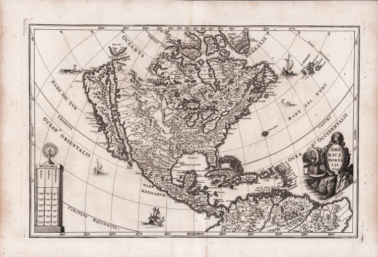
Richly engraved decorative map of North America, showing California as and Island, by Heinrich Scherer (1628-1704).
The Great Lakes are prominently depicted and the Mississippi River originates in two large lakes in present-day Canada, and empties into the "Sinus Mexicanus" too far west.
The map is decorated with a title cartouche, distance scale, ships and sea monsters.
Decorative map by Scherer for his Atlas Novus exhibens orbem terraguem per naturae opera, historiae navae acveterus monumenta, artistique geographicae leges et praecepta...published in eight volumes from 1702-1710 in Munich. Scherer, a devout Jesuit, produced this geographical compendium to depict the Catholic hierarchy and the spread of Jesuit missions throughout the world.
“This map of North America dated 1699 appears in the second part of Heinrich Scherer's Atlas Novus entitled Geographia Hierarchica sive Status Ecclesiastici, published in 1703. Much of the cartography is identical although there are more toponyms, particularly of coastal points. The Rocky Mountains are less pronounced. The title is decorated with various plateware signifying the Spanish Empire's output of metal from the Americas. The same plate was used again in the sixth part entitled the Tabellæ Geographicæ, published in the same year, 1703. The atlas was reissued between 1730-37." (Burden "The Mapping of North America", p. 475).
Copper engraving, in very good condition.
Bibliografia:
Burden "The Mapping of North America", pp. 475-476, n. 756; Tooley (America) p. 131.
Henrick SCHERER (Dilingen 1628 - Monaco 1704)
|
Heinrich Scherer was a devout Jesuit, and professor of mathematics at Munich. His 'Atlas Novus' contained maps of all other parts which showed the spread of Catholicism and Jesuit missions.
|
Henrick SCHERER (Dilingen 1628 - Monaco 1704)
|
Heinrich Scherer was a devout Jesuit, and professor of mathematics at Munich. His 'Atlas Novus' contained maps of all other parts which showed the spread of Catholicism and Jesuit missions.
|