| Reference: | ms5027 |
| Author | Johannes JANSSONIUS |
| Year: | 1639 ca. |
| Zone: | Virginia |
| Printed: | Amsterdam |
| Measures: | 500 x 380 mm |
| Reference: | ms5027 |
| Author | Johannes JANSSONIUS |
| Year: | 1639 ca. |
| Zone: | Virginia |
| Printed: | Amsterdam |
| Measures: | 500 x 380 mm |
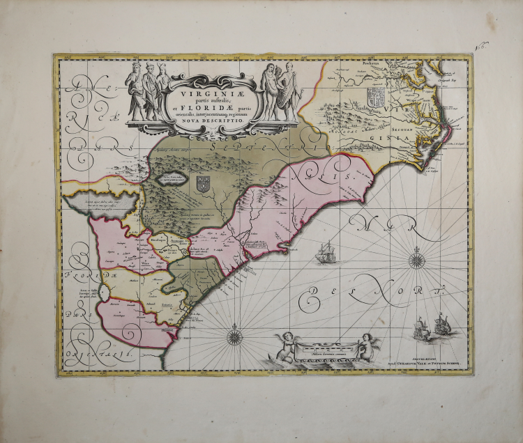
A beautiful map that is one of the most interesting maps of the American southeast.
The map is based upon the Jodocus Hondius' map of the same area-Jansson was Hondius' son-in-law-with some updating. This shows the influence of the Hondius map, and the way his map led to an extensive dissemination of both its correct information and its errors. Hondius's map was a combination of information from two sixteenth century maps, one of the Carolinas, and one of the northern Florida/Georgia region.
These were combined, and in the process many errors were introduced, not the least of which was the straightening out of the St. John's River so that it flowed from an non-existent lake located to the northwest of the mouth of the river.
This lake, which would become Lake Apalachy, appeared on this and other maps well into the eighteenth century. Jansson's map is updated from the Hondius version, including coats-of-arms to indicate the spheres of influence claimed by the French in the Georgia region and the British in the Carolinas. Jansson follows Hondius in the south, but he more accurately depicts the coast in the Carolinas, based on Hessel Gerritsz's map of 1631, and has a more correct image of the mouth of the Chesapeake Bay, indicating for the first time "Newport nesa".
This map shines not only in its interesting cartographic history, but also in its decorative appeal. It is a particularly fine example of the aesthetics of 17th-century Dutch cartography. The elegant calligraphy and compass roses combine with the ships in the sea and the rhumb lines in wonderful embellishment.
The fully colored title and scale cartouches, the latter which shows naked putti and the former half-naked natives, add a final flourish that makes the map a delight to look at. All in all an historic map that is a very fine decorative example of the great age of Dutch cartography,
Joannes Janssonius (Arnhem, 1588-1664), son of the Arnhem publisher Jan Janssen, married Elisabeth Hondius, daughter of Jodocus Hondius, in Amsterdam in 1612. After his marriage, he settled down in this town as a bookseller and publisher of cartographic material. In 1618 he established himself in Amsterdam next door to Blaeu’s book shop. He entered into serious competition with Willem Jansz. Blaeu.. His activities not only concerned the publication of atlases and books, but also of single maps and an extensive book trade with branches in Frankfurt, Danzig, Stockholm, Copenhagen, Berlin, Koningsbergen, Geneva, and Lyon. In 1631 he began publishing atlases together with Henricus Hondius. In the early 1640s Henricus Hondius left the atlas publishing business completely to Janssonius. Competition with Joan Blaeu, Willem’s son and successor, in atlas production prompted Janssonius to enlarge his Atlas Novus finally into a work of six volumes, into which a sea atlas and an atlas of the Old World were inserted. After the death of Joannes Janssonius, the shop and publishing firm were continued by the heirs under the direction of Johannes van Waesbergen (c. 1616-1681), son-in-law of Joannes Janssonius. The copperplates from Janssonius’s atlases were afterwards sold to Schenk and Valck.
Johannes JANSSONIUS (1588-1664)
|
Johannes Janssonius, more commonly known to us as Jan Jansson, was born in Arnhem where his father was a bookseller and publisher (Jan Janszoon the Elder). In 1612 he married the daughter of the cartographer and publisher Jodocus Hondius, and then set up in business in Amsterdam as a book publisher. In 1616 he published his first maps of France and Italy and from then onwards he produced a very large number of maps, perhaps not quite rivalling those of the Blaeu family but running a very close second in quantity and quality. From about 1630 to 1638 he was in partnership with his brother-in-law, Henricus Hondius, issuing further editions of the Mercator/Hondius atlases to which his name was added. On the death of Henricus he took over the business, expanding the atlas still further, until eventually he published an 11-volume Atlas Major on a scale similar to Blaeu's Atlas Major.
The first full edition of Jansson's English County Maps was published in 1646 but some years earlier he issued a number of British maps in the Mercator/Hondius/Jansson series of atlases (1636-44); the maps were printed from newly engraved plates and are different from the later 1646 issue and are now rarely seen (see Appendix B for further details).
In general appearance Jansson's maps are very similar to those of Blaeu and, in fact, were often copied from them, but they tend to be more flamboyant and, some think, more decorative.
After Jansson's death his heirs published a number of maps in an Atlas Contractus in 1666 and later still many of the plates of his British maps were acquired by Pieter Schenk and Gerard Valck, who published them again in 1683 as separate maps.
|