| Reference: | ms7206 |
| Author | Henri Abraham CHATELAIN |
| Year: | 1708 ca. |
| Zone: | Canada |
| Printed: | Amsterdam |
| Measures: | 520 x 410 mm |
| Reference: | ms7206 |
| Author | Henri Abraham CHATELAIN |
| Year: | 1708 ca. |
| Zone: | Canada |
| Printed: | Amsterdam |
| Measures: | 520 x 410 mm |
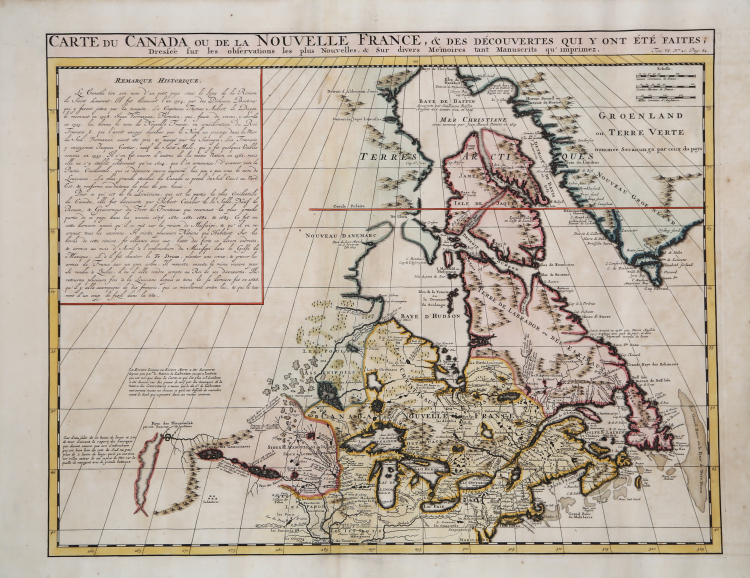
Chatelain's map of Canada was the first printed map to locate Detroit, first issued only 2 years after the founding of the Village by Cadillac.
The map is one of the most important maps of Canada printed during its time. Numerous trading posts and missions in New France and the major towns of the adjacent British colonies are shown. The area around Hudson's Bay is inhabited by native tribes referred to as the "Christinaux or Kilistinons," while Labrador is home to the "Eskimaux."
The map features a number of notes specifically referring to the names of explorers and the dates in which they discovered certain places, such as the reference to 'Nouveau Danemarc', discovered by the Danish explorer, Jan Munk, in 1619. The depiction of the upper Mississippi and Ohio basins is also quite detailed.
Taken from "Atlas Historique" published in Amsterdam between 1705 and 1720.
Henri Abraham Chatelain (1684 - 1743) was a Huguenot pastor of Parisian origins. He is best known as a Dutch cartographer and more specifically for his cartographic contribution in the seminal seven volume Atlas Historique, published in Amsterdam between 1705 and 1720. Innovative for its time, the Atlas Historique combined fine engraving and artwork with scholarly studies of geography, history, ethnology, heraldry, and cosmography. Some scholarship suggests that the Atlas Historique was not exclusively compiled by Henri Chatelain, as is commonly believed, but rather was a family enterprise involving Henri, his father Zacharie and his brother, also Zacharie.
Copperplate, fine later hand colour, in good condition.
Henri Abraham CHATELAIN (1684 - 1743)
|
Henri Abraham Chatelain (1684 - 1743) was a Huguenot pastor of Parisian origins. He is best known as a Dutch cartographer and more specifically for his cartographic contribution in the seminal seven volume Atlas Historique, published in Amsterdam between 1705 and 1720. Innovative for its time, the Atlas Historique combined fine engraving and artwork with scholarly studies of geography, history, ethnology, heraldry, and cosmography. Some scholarship suggests that the Atlas Historique was not exclusively compiled by Henri Chatelain, as is commonly believed, but rather was a family enterprise involving Henri, his father Zacharie and his brother, also Zacharie. The Atlas Historique published by Chatelain was part of a major work of its time, an encyclopaedia in seven volumes including geography as one of its main subjectes. The text was by Nicholas Gueudeville and the maps by Chatelain. The Atlas included one of the finest maps of America (4 sheets) surrounded by vignettes and decorative insets.
1705-20 Atlas Historique:Amsterdam (maps by Chatelain based on G.Delisle)
Further issues to 1739
|