| Reference: | MS6043 |
| Author | Francesco & Paolo SANTINI |
| Year: | 1780 |
| Zone: | Pacific Ocean |
| Printed: | Venice |
| Measures: | 650 x 470 mm |
| Reference: | MS6043 |
| Author | Francesco & Paolo SANTINI |
| Year: | 1780 |
| Zone: | Pacific Ocean |
| Printed: | Venice |
| Measures: | 650 x 470 mm |
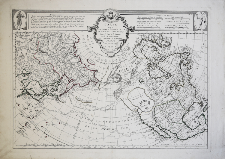
An Italian edition of Joseph Nicolas De L’Isle's important map of the north Pacific. De L’Isle spent many years working as a cartographer in Russia, founding the Academy of Sciences in St. Petersburg and producing the first Russian Atlas. In 1747, De L’Isle returned to France with a manuscript map of the north Pacific, including information on northeastern Asia, northwestern America and the strait between the two.
He produced an engraved map, which was presented to the French Academy of Sciences in 1750. This map was very advanced in some areas, being based on Russian expeditions of 1723, 1732 and 1741, along with Vitus Bering's first and second voyages and the explorations of a number of others such as Tchirkow and Frondat. Unfortunately, the cartography of northwestern America is based on the fictitious account of Admiral de Fonte, showing a huge inland sea, the "Mer de L'Ouest," and waterways leading off towards Baffin's Bay-the long sought for Northwest Passage. Delisle's rendering became the standard for the region until Cook's explorations later in the century.
Delisle's map was copied by many publishers, including the Italian Santini, whose map was later issued by Remondini. The Italian versions have a handsome rococo title cartouche balanced by text and images of a native of Kamchatka and one of Louisiana.
Map compiled by Don Paolo Santini and his brother Francesco, for their prestigious Atlas universel dressé sur les meilleures cartes modernes, a sumptuous Atlas composed of maps that rework the most up-to-date French cartography in a Venetian guise.
The maps are taken from the best geographers of his time, D'Anville, Bellin, Bonne, Borgomo, Boscovich, Clarici, Delisle, Jaillot, Janvier, Robert de Vaugondy. Indeed, in Santini's maps, French terms are mixed with Italian, but they are offered with a compositional and engraving grace that is characteristic of them: an uncluttered toponymy, written large and clearly legible.
Santini's Atlas did not have great publishing success and came out in few copies: it was then reprinted by the Remondini, who had purchased the copperplates from Santini in 1781. To Paolo Santini's maps, dated between 1774 and 1780, the Remondini added several other maps, dated between 1782 and 1784: among them, in the second volume, the large folded maps of Italy, the Republic of Genoa, Palestine, and the large maps of Africa.
Paolo Santini (1729, Venice-1793, Belluno), Catholic priest at the Church of Santa Maria Formosa in Venice, professor of drawing at schools in the Lagooon city of the Venetian Province of the Society of Jesus. Santini, a cartographer, engraver and publisher, updated and published the maps of French geographers and cartographers Gilles Robert de Vaugondy (1688-1766) and Didier Robert de Vaugondy (c. 1723-1786), also drawing inspiration from the works of Italian cartographers, first and foremost those of Giovanni Antonio Rizzi Zannoni (1736-1814). Using, as a model, the maps collected and published in 1752 in the Atlas Universel by Gilles Robert and Didier Robert de Vaugondy, purchased in Paris by his brother, Francesco Santini, and the "best maps" of the time, Paolo Santini engraved new plates and gave to the presses in Venice, in 1776, the Atlas Universel dressé sur les meilleures cartes modernes. The following year, 1777, he sold the publishing rights to publisher Giuseppe Remondini (1754-1811) of Bassano del Grappa, who reprinted the "Atlas Universel" in two volumes that collected a total of 123 maps. The copper plates in the Santini's possession were later purchased, in 1781, by the Remondini printing house.
Copperplate engraving, original outline coloring, in excellent condition.
Bibliografia
NMM III, 277; Nordenskiöld 276; Phillips, Atlases 647. Rodolfo Gallo, L'incisione nel '700 a Venezia e a Bassano, in “Ateneo Veneto”, A. CXXXII, v. 128, pp. 153-214.
Francesco & Paolo SANTINI (Attivi a Venezia seconda metà del XVIII secolo)
|
Paolo Santini (1729 Venice - Belluno 1793) was a priest of the church of Santa Maria Formosa in Venice, and professor of drawing at the public schools of the Jesuits. From the best papers of the time he realized his brother Francis, the famous Atlas Universal, split into two volumes and containing 123 cards. Francesco Santini he published between 1776 and 1780. Then the branches of the intaglio print cards were purchased in 1781 by Bassano Printing Remondini which reissued the atlas.
|