
| Reference: | S4884 |
| Author | John MEARES |
| Year: | 1796 |
| Zone: | Northern Pacific |
| Printed: | Naples |
| Measures: | 570 x 440 mm |
| Reference: | S4884 |
| Author | John MEARES |
| Year: | 1796 |
| Zone: | Northern Pacific |
| Printed: | Naples |
| Measures: | 570 x 440 mm |
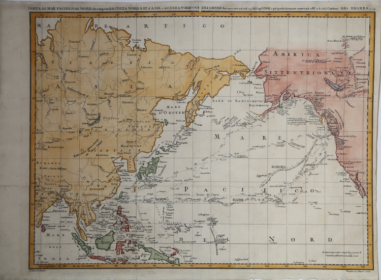
Map of the northern Pacific, showing the eastern coast of Asia and the western coast of North America, from California to Alaska.
This is an Italian version of Meares’ great map of the North Pacific detailing the explorations of Captain Cook from 1778-79 and Captain John Meares from 1788-89.
The map covers a good portion of the Asian and North American continents, but the primary focus is on the tracks of the various explorers through the Northwest, Alaska, Canada, Hawaii and through the Pacific to the Philippines and Southeast Asia.
Meares is one of the more colorful figures in the early European exploration of the Northwest coast and Alaska. He claimed many of the discoveries of others as his own and rekindled the idea of the Sea of the West and a Northwest Passage. His mythical inland sea appears stretching from the Strait of Juan de Fuca northwards to just north of the Queen Charlotte Islands. A note indicates that the American sloop Lady Washington captained by Robert Gray had explored this sea in 1789. This was a complete fabrication on the part of Meares; nevertheless it gave new credence to the idea and appears on several later maps as well.
Imprints at bottom are "P. Giovach Pagani" and "Vascellini inc Giarre scris."
Taken from the rare Italian edition of the "Viaggi dalla China alla costa nord-ouest d'America" by captain John Meares.
Copperplate, with fine later hand colour, in good conditions.
|
Kershaw #1176; cf. McGuirk #216.
|
John MEARES1756? - 1809
|
Kershaw #1176; cf. McGuirk #216.
|
John MEARES1756? - 1809