| Reference: | ms1326 |
| Author | Franz Anton SCHRAEMBL |
| Year: | 1789 |
| Zone: | Yemen |
| Printed: | Nurnberg |
| Measures: | 410 x 600 mm |
| Reference: | ms1326 |
| Author | Franz Anton SCHRAEMBL |
| Year: | 1789 |
| Zone: | Yemen |
| Printed: | Nurnberg |
| Measures: | 410 x 600 mm |
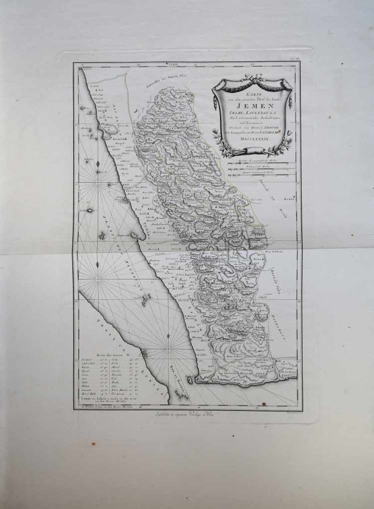
This 1789 Franz Anton Schraembl map of the southwestern part of the Arabian Peninsula is the first printed map specifically of Yemen, and the earliest map to be based on actual exploration of this region. It is derived from data collected by the German mathematician Carsten Niebuhr, who was the sole survivor of the Danish Arabia Expedition (1761-67). The map covers what is now the western part of Yemen and the southwestern extents of Saudi Arabia. Many recognizable place names are shown with accuracy. The ports of Aden and Mocha appear, and do Al Hudaydah, Al Luhayyah, and the Red Sea islands of Kameran, Jazirat Jabel Zuqar, and Perim Island. More impressively (considering that Europeans seldom ventured further than the coast), Sana'a and Damar, Yarim and Taizz are accurately placed, along with many other towns, cities and wadis. Abu Arish, in Saudi Arabia is shown as well. The topography of the inland regions is indicated with hachures. A table in the lower left gives the precise latitude of key cities for ease in location.
The attractively-engraved cartouche is garlanded with coffee branches, alluding to Yemen's signal importance as the originator of coffee. Indeed, until the 18th century, Yemen was the world's only source of coffee cultivated for drinking. Although the plant had begun to be cultivated in Martinique and Saint-Domingue in the 1730s, Yemen still would have been cemented in the European mind as the source of the solace-bringing bean.
This map was published in Vienna by Franz Anton Schraembl for his Allgemeiner Grosser Atlas.
Franz Anton Schraembl (1751 - 1803) was a Vienna based cartographer working in the later part of the 18th century. Schraembl was burnin Vienna and founded his firm in 1787, partnering with fellow Austrian Franz Johann Joseph von Reilly (1766 - 1820), and began his great work, the Allgemeiner Grosser Atlas in the same year. This ambitious large format atlas was to be based upon only the most up-to-date cartographic information available and is based upo the work of cartographers like D'Anville and explorers such as Cook, Roberts, and others. The atlas was finally finished in 1800 but becoming the first Austrian world atlas. The work unfortunately enjoyed only relatively minimal circulation, possibly due to its high cost. The low sales, unfortunately, drove Schraembl into insolvency. His business eventually recovered somewhat with the publication of a diverse array of materials ranging from literature to art books. When Franz Anton died in 1803, the firm was taken over by his widow Johanna and her brother, the engraver Karl Robert Schindelmayer. From 1825 the firm was taken over by his son, Eduard Schraembl.
Etching, impressed on contemporary laid paper blued, finely hand-colored, in excellent condition.
Franz Anton SCHRAEMBL (Attivo a Vienna tra 1751-1803)
|
Franz Anton Schraembl (1751 - 1803) was a Vienna based cartographer working in the later part of the 18th century. Schraembl was burnin Vienna and founded his firm in 1787, partnering with fellow Austrian Franz Johann Joseph von Reilly (1766 - 1820), and began his great work, the Allgemeiner Grosser Atlas in the same year. This ambitious large format atlas was to be based upon only the most up-to-date cartographic information available and is based upo the work of cartographers like D'Anville and explorers such as Cook, Roberts, and others. The atlas was finally finished in 1800 but becoming the first Austrian world atlas. The work unfortunately enjoyed only relatively minimal circulation, possibly due to its high cost. The low sales, unfortunately, drove Schraembl into insolvency. His business eventually recovered somewhat with the publication of a diverse array of materials ranging from literature to art books. When Franz Anton died in 1803, the firm was taken over by his widow Johanna and her brother, the engraver Karl Robert Schindelmayer. From 1825 the firm was taken over by his son, Eduard Schraembl.
|