Arabia Felice Nuova Tavola Girolamo RUSCELLI Code: MS4432 Measures: 260 x 200 mm Year: 1561 ca. Printed: Venice Price €600.00 Quick view View Details
ASIAE VI TAB. Gerard MERCATOR (Kremer) Code: s34886 Measures: 487 x 342 mm Year: 1578 ca. Printed: Cologne Price €1,750.00 Quick view View Details
Arabia Jodocus HONDIUS Jr. Code: MS2381 Measures: 135 x 100 mm Year: 1616 ca. Printed: Amsterdam Price €250.00 Quick view View Details
Ormus Regnum Jodocus HONDIUS Jr. Code: MS2125 Measures: 137 x 98 mm Year: 1616 Printed: Amsterdam Price €150.00 Quick view View Details
TAB. VI ASIAE, Arabiam Felicem, Carmaniam as Sinum Persicum... Gerard MERCATOR (Kremer) Code: s35021 Measures: 480 x 339 mm Year: 1695 ca. Printed: Amsterdam Price €900.00 Quick view View Details
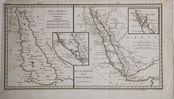
Sinus Arabicus ex Tabulis Hodiernis Ptolemaei Anonimo Code: ms5337 Measures: 460 x 250 mm Year: 1740 ca. Printed: Paris Price €100.00 Quick view View Details
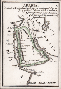
L'Arabia Divisa in Petrea, Deserta, e Felice Antonio ZATTA Code: ms6589 Measures: 410 x 330 mm Year: 1784 ca. Printed: Venice Price €450.00 Quick view View Details
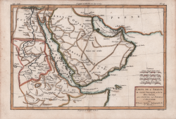
Carte de l'Arabie, du Golfe Persique et de la Mer Rouge, avec... Rigobert BONNE Code: S4376 Measures: 333 x 227 mm Year: 1787 Printed: Paris Price €200.00 Quick view View Details
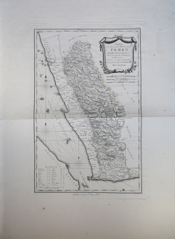
Karte von dem grossten Theil des Lands Jemen.. Franz Anton SCHRAEMBL Code: ms1326 Measures: 410 x 600 mm Year: 1789 Printed: Nurnberg Price €350.00 Quick view View Details
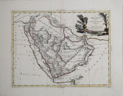
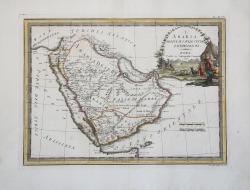
L'Arabia delineata sulle ultime osservazioni Giovanni Maria CASSINI Code: S31479 Measures: 500 x 370 mm Year: 1797 Printed: Rome Price €850.00 Quick view View Details
Arabia Pietro & Giuseppe VALLARDI Code: S42649.17 Measures: 73 x 105 mm Year: 1830 ca. Printed: Milan Price €200.00 Quick view View Details