
| Reference: | s436 |
| Author | Johannes JANSSONIUS |
| Year: | 1657 |
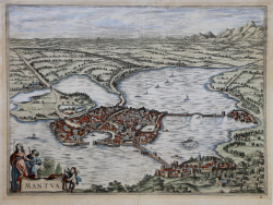
| Zone: | Mantua |
| Printed: | Amsterdam |
| Measures: | 500 x 365 mm |
| Reference: | s436 |
| Author | Johannes JANSSONIUS |
| Year: | 1657 |
| Zone: | Mantua |
| Printed: | Amsterdam |
| Measures: | 500 x 365 mm |
City plan taken from "Theatrum praecipuarum urbium", the famous city-plans book realized by Janssonius after Braun & Hogenberg's "Civitates Orbis Terrarum".
The work was published in 1657, with 500 plates depicting cities from all over the world. In opposition to his main competitors, the Blaeus, to realize his project, Janssonius used the plates of former cartographers and publishers.
In 1653 he bought from Abraham Hogenberg the plates of the "Civitates orbis Terrarum" which have been then included in his work. As far as Dutch cities, he had new plates realized after Johannes Blaeu's Atlas, published in 1649.
The plates in the Fifth Volume, the one about Italy entitled "Theatrum celebriorum urbium Italiae..", Janssonius used the plates realized by Jodocus Hondius for his "Italia Hodierna.." in 1627.
Unlike Hondius' work, Janssonius' is an in-folio size, with text both on recto and on verso.
Etching on copperplate with original hand colour, in good conditions. Latin text to the verso. Rare.
|
D. Ferrari, ""Mantova nelle stampe", 27
|
Johannes JANSSONIUS (1588-1664)
|
Johannes Janssonius, more commonly known to us as Jan Jansson, was born in Arnhem where his father was a bookseller and publisher (Jan Janszoon the Elder). In 1612 he married the daughter of the cartographer and publisher Jodocus Hondius, and then set up in business in Amsterdam as a book publisher. In 1616 he published his first maps of France and Italy and from then onwards he produced a very large number of maps, perhaps not quite rivalling those of the Blaeu family but running a very close second in quantity and quality. From about 1630 to 1638 he was in partnership with his brother-in-law, Henricus Hondius, issuing further editions of the Mercator/Hondius atlases to which his name was added. On the death of Henricus he took over the business, expanding the atlas still further, until eventually he published an 11-volume Atlas Major on a scale similar to Blaeu's Atlas Major.
The first full edition of Jansson's English County Maps was published in 1646 but some years earlier he issued a number of British maps in the Mercator/Hondius/Jansson series of atlases (1636-44); the maps were printed from newly engraved plates and are different from the later 1646 issue and are now rarely seen (see Appendix B for further details).
In general appearance Jansson's maps are very similar to those of Blaeu and, in fact, were often copied from them, but they tend to be more flamboyant and, some think, more decorative.
After Jansson's death his heirs published a number of maps in an Atlas Contractus in 1666 and later still many of the plates of his British maps were acquired by Pieter Schenk and Gerard Valck, who published them again in 1683 as separate maps.
|
|
D. Ferrari, ""Mantova nelle stampe", 27
|
Johannes JANSSONIUS (1588-1664)
|
Johannes Janssonius, more commonly known to us as Jan Jansson, was born in Arnhem where his father was a bookseller and publisher (Jan Janszoon the Elder). In 1612 he married the daughter of the cartographer and publisher Jodocus Hondius, and then set up in business in Amsterdam as a book publisher. In 1616 he published his first maps of France and Italy and from then onwards he produced a very large number of maps, perhaps not quite rivalling those of the Blaeu family but running a very close second in quantity and quality. From about 1630 to 1638 he was in partnership with his brother-in-law, Henricus Hondius, issuing further editions of the Mercator/Hondius atlases to which his name was added. On the death of Henricus he took over the business, expanding the atlas still further, until eventually he published an 11-volume Atlas Major on a scale similar to Blaeu's Atlas Major.
The first full edition of Jansson's English County Maps was published in 1646 but some years earlier he issued a number of British maps in the Mercator/Hondius/Jansson series of atlases (1636-44); the maps were printed from newly engraved plates and are different from the later 1646 issue and are now rarely seen (see Appendix B for further details).
In general appearance Jansson's maps are very similar to those of Blaeu and, in fact, were often copied from them, but they tend to be more flamboyant and, some think, more decorative.
After Jansson's death his heirs published a number of maps in an Atlas Contractus in 1666 and later still many of the plates of his British maps were acquired by Pieter Schenk and Gerard Valck, who published them again in 1683 as separate maps.
|