
| Reference: | S40961 |
| Author | Giovanni Antonio MAGINI |
| Year: | 1595 ca. |
| Zone: | Lombardia |
| Printed: | Bologna |
| Measures: | 485 x 355 mm |
| Reference: | S40961 |
| Author | Giovanni Antonio MAGINI |
| Year: | 1595 ca. |
| Zone: | Lombardia |
| Printed: | Bologna |
| Measures: | 485 x 355 mm |
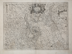
Nel cartiglio in alto al centro, con le allegorie della Giustizia e dell’Abbondanza, si trova il titolo PARTE ALPESRE DELLO STATO DI MILANO. Con il Lago Maggiore di Lugano, e di Como. Nel cartiglio a destra, dove si notano abrasioni, è invece incisa la dedica All’ Ill.mo et Rev.mo mio Sig.r et P[at]ron[us] Col.mo il S.r Card.e Borromeo. Segue l’imprint editoriale Fabio di Gio. Ant.o Magini. In alto a sinistra in una colonna la scala grafica Scala di Miglia dieci (10 miglia pari a mm 50). Orientazione nei quattro lati al centro con il nome dei punti cardinali Septentrio, Meridies, Oriens, Occidens, il nord in alto. Graduazione ai margini di 1’ in 1’ da 44° 54’ a 45° 54’ 15’’ di latitudine, e da 29° 57’ a 31° 54’ 30’’ di longitudine.
"Le carte dello Stato di Milano nell'Italia maginiana sono cinque [...] sono della stessa fattura e del medesimo stile delle carte del Piemonte e della Liguria della prima redazione e come quelle sono certo opera dell'incisore Arnoldo di Arnoldi; le dediche sono tutte firmate da Fabio Magini, ma parte sono aggiunte posteriormente, parte sono sovrapposte ad altre precedenti cancellate sul rame. Queste carte dello Stato di Milano sono certamente tra le prime, alle quali il Magini mise mano nell'accingersi alla sua grande opera: sappiamo infatti dalla lettera al duca di Mantova in data 25 novembre 1596, che a quell'epoca esse erano già intagliate" (cfr. Roberto Almagià, L'Italia di Giovanni Antonio Magini e la Cartografia dell'Italia nei secoli XVI e XVII (1922), p. 30).
Le fonti cartografiche per questa mappa, come giustamente nota Almagià, sono da ricercarsi nelle precedenti carte a stampa - la Langobardia di Luca Antonio degli Uberti del 1520 circa, la Lombardia di Giacomo Gastaldi del 1559, il Ducatus Mediolanensis di Giorgio Settala riprodotto da A. Ortelius nel 1570, la Lombardia di Gerard Mercator del 1589 - e nella pittura di Ignazio Danti nelle Logge Vaticane.
Esemplare di secondo stato con la dedica di Fabio Magini, tratto dal L’Italia, edito a Bologna nel 1620, tre anni dopo la scomparsa del padre.
Composto da un breve testo descrittivo di sole 24 carte, l’opera è corredata di 61 carte geografiche della penisola, e costituisce il primo esempio di atlante italiano. L’opera è per intero di mano del Magini, che iniziò la realizzazione delle carte nel 1594 circa, dando alla luce per prima nel 1595 la carta del territorio di Bologna. Tutte le carte vennero alle stampe quindi prima del 1620, nelle loro stesure provvisorie, successivamente corrette ed aggiornate per l’edizione definitiva. Per la realizzazione delle lastre il Magini si servì di due dei più famosi intagliatori dell’epoca: il belga Arnoldo Arnoldi e l’inglese Benjamin Wright.
Bibliografia
R. Almagià, L'Italia di Giovanni Antonio Magini e la Cartografia dell'Italia nei secoli XVI e XVII (1922): pp. 30-34, n. 4.
Giovanni Antonio MAGINI (1555 - 1617)
|
Giovanni Antonio Magini was born in Padua in 1555, dedicating himself to the study of astronomy from an early age. In 1588 the Senate of Bologna appointed him Lecturer of Astronomy at the local University, choosing him instead of Galileo Galilei. His friendship with the Duke of Mantua, Vincenzo Gonzaga, helped Magini in his quest to obtain cartographical material for map-making from the various sovereigns ruling the different Italian states at that time. Because of Magini's early death in 1617, this effort was made famous by his son Fabio when he published the atlas "L'Italia" in Bologna in 1620. This is the first example of an Italian atlas and is made up of 24 pages of descriptive text and 61 maps of the Italian peninsula. Although this work was published posthumously, it can be entirely ascribed to Magini. He began drawing this maps around 1594, with the one depicting Bologna and its surrounding territories being the first. They were all printed before 1620 in draft editions which were then revised and updated for the final version. These draft proofs are extremely rare, although sometimes available for sale, and exhibit substantial differences in respect to the maps finally included in the atlas. Two of the most famous engravers of the time, Arnoldo Arnoldi and the englishman Benjamin Wright, were entrusted by Magini to engrave the plates. As we shall see in the presentation of the separate maps, they derive from different sources, both known and unknown, and therefore represent the result of an original work of critical analysis and compilation. This atlas had an important influence on the cartography of the italian peninsula for the following two centuries, beginning from Ortelius and going on to the principal dutch cartographers and editors.
|