
| Reference: | S9522 |
| Author | Pieter SCHENK |
| Year: | 1703 |
| Zone: | Central Italy |
| Printed: | Amsterdam |
| Measures: | 485 x 380 mm |
| Reference: | S9522 |
| Author | Pieter SCHENK |
| Year: | 1703 |
| Zone: | Central Italy |
| Printed: | Amsterdam |
| Measures: | 485 x 380 mm |
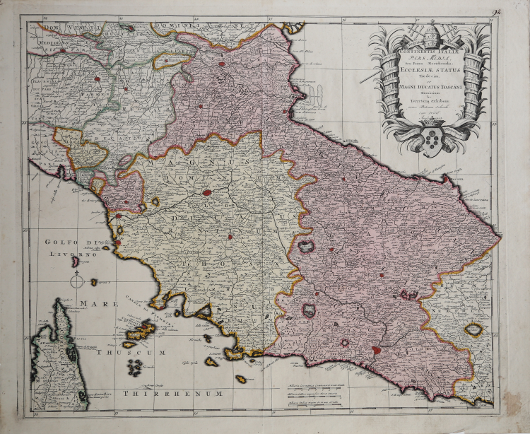
Dettagliata carta geografica dello Stato della Chiesa con la Toscana, tratta dall'opera Atlas Contractus, sive Mapporum Geographicarum Sansionarum auctarum et correctarum Nova Congeries Pieter Schenk, stampato in torno al 1705 circa ad Amsterdam. Della raccolta sono note anche delle ristampe datate 1709 e 1719 ad opera del figlio Pieter Schenk II.
“Graduata sui quattro lati, di 10' in 10', va da 41° 20' a 44° 55' lat. e da 32° a 37° 50' long. Orientazione con una rosa dei venti estremamente semplificata. Scale in miglia tedesche, francesi e italiane. Con scritte in latino riporta le denominazioni delle suddivisioni territoriali, comprese quelle interne agli stati. Colpisce la fittezza dei toponimi dei centri abitati, oltre alla precisione calligrafica con cui essi sono resi; i caratteri risultano però pressoché identici per forme e dimensioni, così che non se ne comprende la diversa importanza. Il disegno del reticolo idrografico è ben evidente, ma non sono riportati i nomi dei corsi d'acqua. È di sicura utilità per studi sull'assetto insediativo e per ricerche di paleotoponomastica dell'area tosco-umbra” (cfr. "Le antiche terre del Ducato di Spoleto", p. 128).
Acquaforte, bella coloritura coeva, in ottimo stato di conservazione.
|
F. Ronca e A. Sorbini (a cura di) "Le antiche terre del Ducato di Spoleto", p. 128, 50
|
Pieter SCHENK (1660 - 1718 ca.)
|
Petrus Schenck, or Pieter, or Peter Schenk the Elder (baptized: 26 December 1660 – between 12 August and 17 November 1711 in Leipzig) was a German engraver and cartographer active in Amsterdam and Leipzig. The engraver and map publisher Peter Schenk was born in 1660 in Elberfeld. He moved to Amsterdam in 1675 and became a student of Gerard Valck specializing in mezzotint. Valck was married to Maria Bloteling, the sister of the Amsterdam engraver Abraham Bloteling. In 1687 Schenk married Gerard's sister Agatha Valck. In 1694, together with Valck, he bought some of the copperplates of the artdealer and cartographer Johannes Janssonius. Along with Valck and Bloteling, he produced prints for the London market, though it is not known if he ever went there with them. Until 1700 he lived in the Jordaan, then he moved to Dam Square or to Leipzig, where he opened a shop, selling maps and art. He was a regular visitor to the trade fair Leipziger Messe in Leipzig, where he died. He had three sons who became engravers. His eldest son Peter Schenk the Younger was also a noted cartographer and art dealer who continued his father's shop in Leipzig. His sons Jan and Leonard stayed in Amsterdam and probably continued their father's workshop. His daughter Maria married Leonard Valck, the son of Gerard, who continued Gerard's workshop.
|
|
F. Ronca e A. Sorbini (a cura di) "Le antiche terre del Ducato di Spoleto", p. 128, 50
|
Pieter SCHENK (1660 - 1718 ca.)
|
Petrus Schenck, or Pieter, or Peter Schenk the Elder (baptized: 26 December 1660 – between 12 August and 17 November 1711 in Leipzig) was a German engraver and cartographer active in Amsterdam and Leipzig. The engraver and map publisher Peter Schenk was born in 1660 in Elberfeld. He moved to Amsterdam in 1675 and became a student of Gerard Valck specializing in mezzotint. Valck was married to Maria Bloteling, the sister of the Amsterdam engraver Abraham Bloteling. In 1687 Schenk married Gerard's sister Agatha Valck. In 1694, together with Valck, he bought some of the copperplates of the artdealer and cartographer Johannes Janssonius. Along with Valck and Bloteling, he produced prints for the London market, though it is not known if he ever went there with them. Until 1700 he lived in the Jordaan, then he moved to Dam Square or to Leipzig, where he opened a shop, selling maps and art. He was a regular visitor to the trade fair Leipziger Messe in Leipzig, where he died. He had three sons who became engravers. His eldest son Peter Schenk the Younger was also a noted cartographer and art dealer who continued his father's shop in Leipzig. His sons Jan and Leonard stayed in Amsterdam and probably continued their father's workshop. His daughter Maria married Leonard Valck, the son of Gerard, who continued Gerard's workshop.
|