
| Reference: | S9682 |
| Author | Reiner & Joshua OTTENS |
| Year: | 1725 ca. |
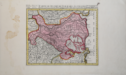
| Zone: | Ferrara |
| Printed: | Amsterdam |
| Measures: | 305 x 260 mm |
| Reference: | S9682 |
| Author | Reiner & Joshua OTTENS |
| Year: | 1725 ca. |
| Zone: | Ferrara |
| Printed: | Amsterdam |
| Measures: | 305 x 260 mm |
Copper engraving, finely hand-colored, in excellent condition. Rare.
This map is a reduction of the map made by Pierre Mortier, inspired by Nicolas Sanson.
|
Tooley p. 479 - A. Alberghini (a cura di) "Ferrara..." p. 62
|
|
The family business of print and map selling was founded by Joachim Ottens but the active period of map publishing was concentrated in the years between 1720 and 1750 when the brothers, Reiner and Joshua, produced enormous collections of maps, some as large as 15 volumes.
These, including copies of practically all maps available at the time, were made up to order and were magnificently coloured. Besides these specially prepared collections they also issued single-volume atlases with varying contents as well as pocket atlases.
|
|
Tooley p. 479 - A. Alberghini (a cura di) "Ferrara..." p. 62
|
|
The family business of print and map selling was founded by Joachim Ottens but the active period of map publishing was concentrated in the years between 1720 and 1750 when the brothers, Reiner and Joshua, produced enormous collections of maps, some as large as 15 volumes.
These, including copies of practically all maps available at the time, were made up to order and were magnificently coloured. Besides these specially prepared collections they also issued single-volume atlases with varying contents as well as pocket atlases.
|