| Reference: | s30248 |
| Author | Thomas KITCHIN |
| Year: | 1790 |
| Zone: | England & Wales |
| Printed: | London |
| Measures: | 1100 x 800 mm |
| Reference: | s30248 |
| Author | Thomas KITCHIN |
| Year: | 1790 |
| Zone: | England & Wales |
| Printed: | London |
| Measures: | 1100 x 800 mm |
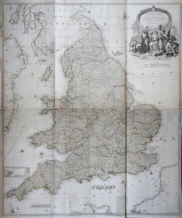
A very detailed map of England and Wales showing roads by type, cities, distances, market towns, latitude and longitude of important places, villages with and without stages, distances from London, and more. John Rocque was a prolific map maker in London during the 18th century.
This map as well as his two sheet map of Ireland appeared in Thomas Kitchin's A General Atlas Describing the Whole Universe of 1790.
Shows forested areas, classified roads with distances, etc. Relief shown pictorially. Includes inset map of the Isles of Scilly and drawings of ships.
Engraved map printed on 4 sheets comprising. Counties in outline color. In very good contion.
|
English engraver and cartographer, who became hydrographer to the king. He was also an author, who wrote about the history of the West Indies.He produced John Elphinstone's map of Scotland (1746), Geographia Scotiae (1749), and The Small English Atlas (1749) with Thomas Jefferys. The Large English Atlas (with Bowen 1749–60) was a serious attempt to cover England at large scale. In 1755 Kitchin engraved the Mitchell Map map of North America.He worked for London Magazine. He produced 170 maps for London Magazine (1747–83). Kitchin was the head hydrographer for the King of England. Kitchin frequently stole the works of other cartographers, which is one reason why he "created" so much work as a cartographer.
|
|
English engraver and cartographer, who became hydrographer to the king. He was also an author, who wrote about the history of the West Indies.He produced John Elphinstone's map of Scotland (1746), Geographia Scotiae (1749), and The Small English Atlas (1749) with Thomas Jefferys. The Large English Atlas (with Bowen 1749–60) was a serious attempt to cover England at large scale. In 1755 Kitchin engraved the Mitchell Map map of North America.He worked for London Magazine. He produced 170 maps for London Magazine (1747–83). Kitchin was the head hydrographer for the King of England. Kitchin frequently stole the works of other cartographers, which is one reason why he "created" so much work as a cartographer.
|