
| Reference: | s30249 |
| Author | Thomas KITCHIN |
| Year: | 1794 |
| Zone: | England & Wales |
| Printed: | London |
| Measures: | 1080 x 1260 mm |
| Reference: | s30249 |
| Author | Thomas KITCHIN |
| Year: | 1794 |
| Zone: | England & Wales |
| Printed: | London |
| Measures: | 1080 x 1260 mm |
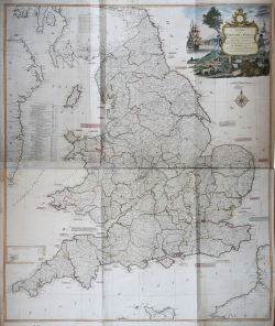
A wall map of England & Walles, printed on 4 double-sheets joined. Shows counties, settlements, roads with distances to London, finished and unfinished canals, rivers intended to be made navigable, etc.
Has illustrated cartouche and table "The inland navigations in England &c." Relief shown pictorially.
Includes inset of the Isles of Scilly.
Published in: A new universal atlas, exhibiting all the empires, kingdoms, states, republics, &c. &c. in the whole World…London, R. Laurie & J. Whittle, 1804.
Etching, in outline color, in very good condition.
|
Shirley R. Maps in the atlases of the British Library, T.LAU-1c (1799 ed.); NMM 375 (3rd ed. 1801)
|
|
English engraver and cartographer, who became hydrographer to the king. He was also an author, who wrote about the history of the West Indies.He produced John Elphinstone's map of Scotland (1746), Geographia Scotiae (1749), and The Small English Atlas (1749) with Thomas Jefferys. The Large English Atlas (with Bowen 1749–60) was a serious attempt to cover England at large scale. In 1755 Kitchin engraved the Mitchell Map map of North America.He worked for London Magazine. He produced 170 maps for London Magazine (1747–83). Kitchin was the head hydrographer for the King of England. Kitchin frequently stole the works of other cartographers, which is one reason why he "created" so much work as a cartographer.
|
|
Shirley R. Maps in the atlases of the British Library, T.LAU-1c (1799 ed.); NMM 375 (3rd ed. 1801)
|
|
English engraver and cartographer, who became hydrographer to the king. He was also an author, who wrote about the history of the West Indies.He produced John Elphinstone's map of Scotland (1746), Geographia Scotiae (1749), and The Small English Atlas (1749) with Thomas Jefferys. The Large English Atlas (with Bowen 1749–60) was a serious attempt to cover England at large scale. In 1755 Kitchin engraved the Mitchell Map map of North America.He worked for London Magazine. He produced 170 maps for London Magazine (1747–83). Kitchin was the head hydrographer for the King of England. Kitchin frequently stole the works of other cartographers, which is one reason why he "created" so much work as a cartographer.
|