
| Reference: | MS7940 |
| Author | Jean Baptiste NOLIN |
| Year: | 1701 ca. |
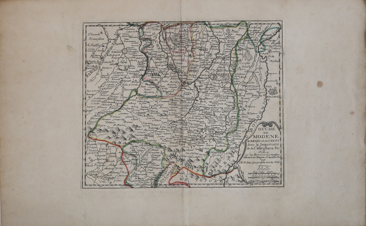
| Zone: | Modena |
| Printed: | Paris |
| Measures: | 310 x 430 mm |
| Reference: | MS7940 |
| Author | Jean Baptiste NOLIN |
| Year: | 1701 ca. |
| Zone: | Modena |
| Printed: | Paris |
| Measures: | 310 x 430 mm |
The map is made for Le Theatre de la Guerre en Italie, first published in 1701. The work describes in detail the Italian Campaign of 1701-1702 which involved territories of northern Italy with Milan, Cremona, Mantua, Parma, Modena, Bergamo, Crema, Brescia, Verona, Vicenza, Padua, Ferrara and Bologna.
Jean-Baptiste Nolin (ca. 1657-1708) was a French engraver who worked at the turn of the eighteenth century. Initially trained by Francois de Poilly, his artistic skills caught the eye of Vincenzo Coronelli when the latter was working in France. Coronelli encouraged the young Nolin to engrave his own maps, which he began to do.
Whereas Nolin was a skilled engraver, he was not an original geographer.
Nolin, had difficulty in making original maps and, therefore, referred to models of other geographers. Many of his works are based on the engravings of Coronelli - some made in collaboration - and another French cartographer, Jean Nicolas de Tralage called Tillemon.
Another source for his maps was the information that came from the wars in Europe, to which he had access being "geographe du Roy". In 1701 the same Nolin published Le Theatre de la Guerre en Italie, a collection consisting of initial 18 maps that was soon reprinted and updated.
Copper engraving, contemporary coloring, in good condition.
Jean Baptiste NOLIN (circa 1657 - 1708)
|
Jean-Baptiste Nolin (ca. 1657-1708) was a French engraver who worked at the turn of the eighteenth century. Initially trained by Francois de Poilly, his artistic skills caught the eye of Vincenzo Coronelli when the latter was working in France. Coronelli encouraged the young Nolin to engrave his own maps, which he began to do.
Whereas Nolin was a skilled engraver, he was not an original geographer. He also had a flair for business, adopting monikers like the Geographer to the Duke of Orelans and Engerver to King XIV. He, like many of his contemporaries, borrowed liberally from existing maps. In Nolin’s case, he depended especially on the works of Coronelli and Jean-Nicholas de Tralage, the Sieur de Tillemon. This practice eventually caught Nolin in one of the largest geography scandals of the eighteenth century.
In 1700, Nolin published a large world map which was seen by Claude Delisle, father of the premier mapmaker of his age, Guillaume Delisle. Claude recognized Nolin’s map as being based in part on his son’s work. Guillaume had been working on a manuscript globe for Louis Boucherat, the chancellor of France, with exclusive information about the shape of California and the mouth of the Mississippi River. This information was printed on Nolin’s map. The court ruled in the Delisles’ favor after six years. Nolin had to stop producing that map, but he continued to make others.
Calling Nolin a plagiarist is unfair, as he was engaged in a practice that practically every geographer adopted at the time. Sources were few and copyright laws weak or nonexistent. Nolin’s maps are engraved with considerable skill and are aesthetically engaging.
Nolin’s son, also Jean-Baptiste (1686-1762), continued his father’s business.
|