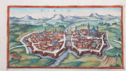
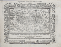
Le vif pourtrait de la noble ville & Cité de Parme Antoine Du PINET Code: MS7453 Measures: 325 x 260 mm Year: 1564 Printed: Lyon Price €700.00 Quick view View Details
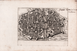
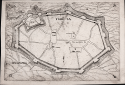
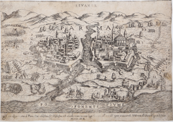
Piaseza Ferrando BERTELLI Code: S39329 Measures: 290 x 200 mm Year: 1568 ca. Printed: Venice Price €1,000.00 Quick view View Details
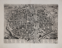
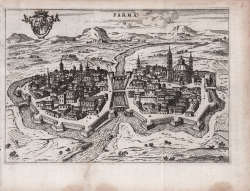
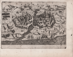
Parma Ferrando BERTELLI Code: S39328 Measures: 245 x 180 mm Year: 1568 Printed: Venice Price €1,200.00 Quick view View Details
Il Vero Disegno e l'istato di Parma Città Nobilissima, e... Donato BERTELLI Code: S30050 Measures: 260 x 185 mm Year: 1569 Printed: Venice Price €900.00 Quick view View Details
Parma - Il vero disegno e ritrato di Parma Citta nobilissima, et... Paolo FORLANI Code: MS7279 Measures: 253 x 176 mm Year: 1569 Printed: Venice Price €900.00 Quick view View Details
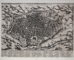
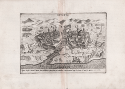
PIASE[N]ZA Paolo FORLANI Code: IT27126 Measures: 268 x 168 mm Year: 1569 Printed: Venice Price €750.00 Quick view View Details
Parma Georg BRAUN & Franz HOGENBERG Code: s32634 Measures: 232 x 125 mm Year: 1572 Printed: Antwerpen & Cologne Price €250.00 Quick view View Details
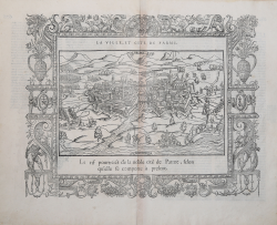
La Ville, et Cite de Parme Francois de BELLEFOREST Code: s27228 Measures: 435 x 350 mm Year: 1575 ca. Printed: Paris Price €600.00 Quick view View Details
La Nobilissima Citta di Parma Marcello Clodio Code: S41921 Measures: 445 x 325 mm Year: 1589 Printed: Rome Price €4,500.00 Quick view View Details
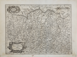
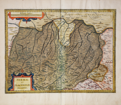
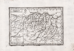
Ducato di Parma et di Piacenza Giovanni Antonio MAGINI Code: S40967 Measures: 462 x 350 mm Year: 1598 ca. Printed: Bologna Price €400.00 Quick view View Details
La Nobiliss.a Citta di Piacenza Matteo FLORIMI Code: S41924 Measures: 505 x 380 mm Year: 1600 ca. Printed: Siene Price €2,500.00 Quick view View Details
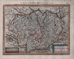
Parmae et Placentiae Ducatus Johannes Baptiste VRIENTS Code: S46075 Measures: 480 x 365 mm Year: 1608 ca. Printed: Antwerpen Price €1,200.00 Quick view View Details
Ducato di Parma et Piacenza Johannes JANSSONIUS Code: S48169 Measures: 200 x 155 mm Year: 1628 ca. Printed: Amsterdam Price €150.00 Quick view View Details
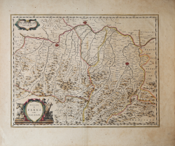
Ducato di Parma et di Piacenza Willem Janszoon BLAEU Code: S40190 Measures: 500 x 385 mm Year: 1640 ca. Printed: Amsterdam Price €400.00 Quick view View Details
PARMA Giacomo LAURO Code: S39426 Measures: 240 x 182 mm Year: 1642 ca. Price €1,000.00 Quick view View Details
Parma Francesco SCOTO Code: S47421 Measures: 180 x 120 mm Year: 1650 ca. Printed: Rome Price €150.00 Quick view View Details
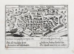
Rerum Omnium Sua Sunt Tempora. Piacenza in Italia Daniel MEISNER Code: s23031 Measures: 150 x 100 mm Year: 1678 ca. Printed: Nurnberg Price €225.00 Quick view View Details
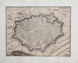
Placentia Carl RIEGEL Code: MS8405 Measures: 185 x 145 mm Year: 1692 Printed: Frankfurt Price €130.00 Quick view View Details
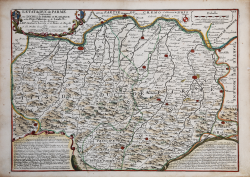
L'Etat du Duc de Parme, Contenant Les Duches de Parme et Plaisance... Jean Baptiste NOLIN Code: S630 Measures: 437 x 315 mm Year: 1701 ca. Printed: Paris Price €280.00 Quick view View Details
Ducati di Parma e Piacenza Vincenzo CORONELLI Code: S47224 Measures: 180 x 130 mm Year: 1706 Printed: Venice Price €350.00 Quick view View Details
![PIASE[N]ZA](https://www.antiquarius.it/34523-home_default/piaseza.jpg)