
| Reference: | S37858 |
| Author | Nicolas SANSON |
| Year: | 1679 |
| Zone: | East Indies |
| Printed: | Paris |
| Measures: | 530 x 380 mm |
| Reference: | S37858 |
| Author | Nicolas SANSON |
| Year: | 1679 |
| Zone: | East Indies |
| Printed: | Paris |
| Measures: | 530 x 380 mm |
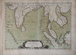
Sanson's important mid-seventeenth century map of India and Southeast Asia, with the engraved date 1679.
First published in 1654 and issued separately, then included in Sanson's Atlas Les Cartes Générales de toutes parties du Monde, first issued 1658.
It covers most of modern India, Bangladesh and Burma, the whole of Sri Lanka, Thailand, Malaysia, Laos, Cambodia, and Vietnam, and parts of Indonesia and China, showing the cities and smaller settlements, rivers and mountain chains, as well as the borders of the seventeenth-century kingdoms and other major political divisions, most of them further subdivided.
With decorative title and imprint in a cartouche at the foot in the form of a cloth in an enormous shell floating on the sea: with the equator and Tropic of Cancer marked and latitude and longitude indications in the borders.
It was engraved by J. Somer for the elder Nicolas Sanson, dated 1654 and with a privilege for twenty years, and appeared in Sanson's 1658 Cartes generales de toutes les parties du monde and later editions.
Of considerable historical interest for the state of European knowledge of India and Southeast Asia in the mid-seventeenth century.
Copperplate with fine original colour, very good condition.
Nicolas SANSON (Abbeville 1600 - Parigi 1667)
|
Nicolas Sanson (December 20, 1600 - July 7, 1667) and his descendants were the most influential French cartographers of the 17th century and laid the groundwork for the Golden Age of French Cartography. Sanson was born in Picardy, but his family was of Scottish Descent. He studied with the Jesuit Fathers at Amiens. Sanson started his career as a historian where, it is said, he turned to cartography as a way to illustrate his historical studies. In the course of his research some of his fine maps came to the attention of King Louis XIII who, admiring the quality of his work, appointed Sanson Geographe Ordinaire du Roi. Sanson's duties in this coveted position included advising the king on matters of geography and compiling the royal cartographic archive. In 1644 he partnered with Pierre Mariette, an established print dealer and engraver, whose business savvy and ready capital enabled Sanson to publish an enormous quantity of maps. Sanson's corpus of some three hundred maps initiated the golden age of French mapmaking and he is considered the 'Father of French Cartography.' His work is distinguished as being the first of the 'Positivist Cartographers,' a primarily French school of cartography that valued scientific observation over historical cartographic conventions. The practice result of the is less embellishment of geographical imagery, as was common in the Dutch Golden Age maps of the 16th century, in favor of conventionalized cartographic representational modes. Sanson is most admired for his construction of the magnificent atlas Cartes Generales de Toutes les Parties du Monde. Sanson's maps of North America, Amerique Septentrionale (1650), Le Nouveau Mexique et La Floride (1656), and La Canada ou Nouvelle France (1656) are exceptionally notable for their important contributions to the cartographic perceptions of the New World. Both maps utilize the discoveries of important French missionaries and are among the first published maps to show the Great Lakes in recognizable form. Sanson was also an active proponent of the insular California theory, wherein it was speculated that California was an island rather than a peninsula. After his death, Sanson's maps were frequently republished, without updates, by his sons, Guillaume (1633 - 1703) and Adrien Sanson (1639 - 1718). Even so, Sanson's true cartographic legacy as a 'positivist geographer' was carried on by others, including Alexis-Hubert Jaillot, Guillaume De L'Isle, Gilles Robert de Vaugondy, and Pierre Duval.
|