| Reference: | s34942 |
| Author | Henrick SCHERER |
| Year: | 1702 ca. |
| Zone: | East Indies |
| Printed: | Munich |
| Measures: | 348 x 227 mm |
| Reference: | s34942 |
| Author | Henrick SCHERER |
| Year: | 1702 ca. |
| Zone: | East Indies |
| Printed: | Munich |
| Measures: | 348 x 227 mm |
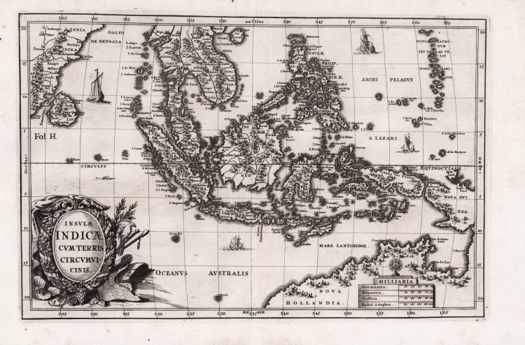
Fascinating map of Southeast Asia. Includes today's Malaysia, Thailand, Vietnam, Singapore, Indonesia, Ceylon.
Nova Hollandia (Australia) is depicted at bottom right with hills and forests along the coasts. Nova Guinea is almost attached to Nova Hollandia. The coastline shows Van Arnham's Land, Van Der Lin, C. Diemen and C. Van Diemen's Land.
Decorative map by Heinrich Scherer for his Atlas Novus exhibens orbem terraguem per naturae opera, historiae navae acveterus monumenta, artistique geographicae leges et praecepta...published in eight volumes from 1702-1710 in Munich. Scherer, a devout Jesuit, produced this geographical compendium to depict the Catholic hierarchy and the spread of Jesuit missions throughout the world.
The 180 maps included in this work were prepared between 1699 and 1700 and were engraved by Leonard Hecknaeur, Joseph Montelegre or Matthus Wolfgang with each volume introduced by fine allegorical frontispieces by the same engravers.
Copper engraving, in very good condition.
|
Parry, p.163 pl.5.35.Tooley (Australia) #1124.
|
Henrick SCHERER (Dilingen 1628 - Monaco 1704)
|
Heinrich Scherer was a devout Jesuit, and professor of mathematics at Munich. His 'Atlas Novus' contained maps of all other parts which showed the spread of Catholicism and Jesuit missions.
|
|
Parry, p.163 pl.5.35.Tooley (Australia) #1124.
|
Henrick SCHERER (Dilingen 1628 - Monaco 1704)
|
Heinrich Scherer was a devout Jesuit, and professor of mathematics at Munich. His 'Atlas Novus' contained maps of all other parts which showed the spread of Catholicism and Jesuit missions.
|