
| Reference: | s28379 |
| Author | Girolamo RUSCELLI |
| Year: | 1561 ca. |
| Zone: | East Indies |
| Printed: | Venice |
| Measures: | 265 x 200 mm |
| Reference: | s28379 |
| Author | Girolamo RUSCELLI |
| Year: | 1561 ca. |
| Zone: | East Indies |
| Printed: | Venice |
| Measures: | 265 x 200 mm |
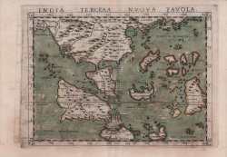
Important Ruscelli map of Southeast Asia, based on Gastaldi’s map of the region dated 1548. It is one of the earliest modern maps of Southeast Asia. and one of the earliest to introduce Portuguese discoveries of the region.
The map covers the area from the Gulf of Bengal to the southern coast of China, as far south as Java and Timor, and to the northeast of Timor, the island of Gilolo. The Isthmus of Kra, Malaysia and Sumatra are all strangely shaped, with the isthmus appearing to be very short and narrow and Malaysia significantly larger than it is. Sumatra is also inaccurately presented. Numerous mountain ranges and river systems are depicted, and the oceans, seas and bays are stippled. Many place names are recognizable.
These depictions, along with nearby islands and early place names, provide a fascinating 16th century view of the topography of the region.
Etching with engraving, about 1561. Magnificent proof, printed on contemporary laid paper, with margins, in perfect condition. Example in wonderful contemporary coloring.
Map taken from Geographia di Claudio Tolomeo edited by Girolamo Ruscelli, published in Venice in several editions between 1561 and 1598. The maps is based on the Geografia by Giacomo Gastaldi (1548), who probably also personally drew these maps, which were engraved by the brothers Livio and Giulio Sanuto.
The peculiarity of these maps is that they are engraved two for plate and subsequently cut; this is why the copper sign only appears on three sides of the map. Ruscelli's text and his maps are considered to be the best modern atlas up to the first version of Abraham Ortelius' Theatrum Orbis Terrarum (1570).
Only their widespread diffusion prevents a sustained evaluation in the antiquarian market. In fact, the work had a first edition in 1561, printed by Vincenzo Valgrisi who also edited the 1562 reprint. There are three editions signed by Giordano Ziletti (two in 1564 and one in 1574), while in 1597 it was published by the Calignani brothers. All these editions contain 64 plates. In 1598 and 1599 the two editions edited by Giuseppe Rosaccio and printed by the heirs of Melchior Sessa came to light. These last two editions include 69 plates; in fact, Rosaccio's map of the planisphere and continents has been added.
Example of Ruscelli’s maps in contemporary coloring are absolutely rare.
Girolamo RUSCELLI (Viterbo 1504 – Venezia 1566)
|
Girolamo Ruscelli was an Italian humanist, publisher and cartographer active in Venice in the early 16th century. Born in Viterbo, Ruscelli lived in Aquileia, Padua, Rome and Naples before moving to Venice, where he spent most of his life. Cartographically, Ruscelli is best known for his important revision of Ptolemy's Geographia, published in 1561. Based on an expansion of Giacomo Gastaldi's 1548 work Ptolemy, Ruscelli added some 37 new “Ptolemaic” maps to his Italian translation of the Geographia. Ruscelli is also listed as the editor of such important works as Boccaccio's Decameron, Petrarch's verses, Ariosto's Orlando Furioso, and various other works. In addition to his well-known cartographic work, many scholars associate Ruscelli with Alexius Pedemontanus, author of the popular De' Secreti del R. D. Alessio Piemontese. This well-known work, or “Book of Secrets,” was a collection of scientific and quasi-scientific medical recipes, household advice and technical commentary on a range of subjects that included metallurgy, alchemy, dyeing and perfume making. Ruscelli, as Alexius, founded an “Academy of Secrets,” a group of nobles and humanists dedicated to the discovery of “forbidden” scientific knowledge. This was the first known experimental scientific society and was later imitated by numerous other groups throughout Europe, including the Academy of Secrets in Naples.
|