| Reference: | MS4031 |
| Author | Nicolas DE FER |
| Year: | 1717 ca. |
| Zone: | Indochina |
| Printed: | Paris |
| Measures: | 160 x 140 mm |
| Reference: | MS4031 |
| Author | Nicolas DE FER |
| Year: | 1717 ca. |
| Zone: | Indochina |
| Printed: | Paris |
| Measures: | 160 x 140 mm |
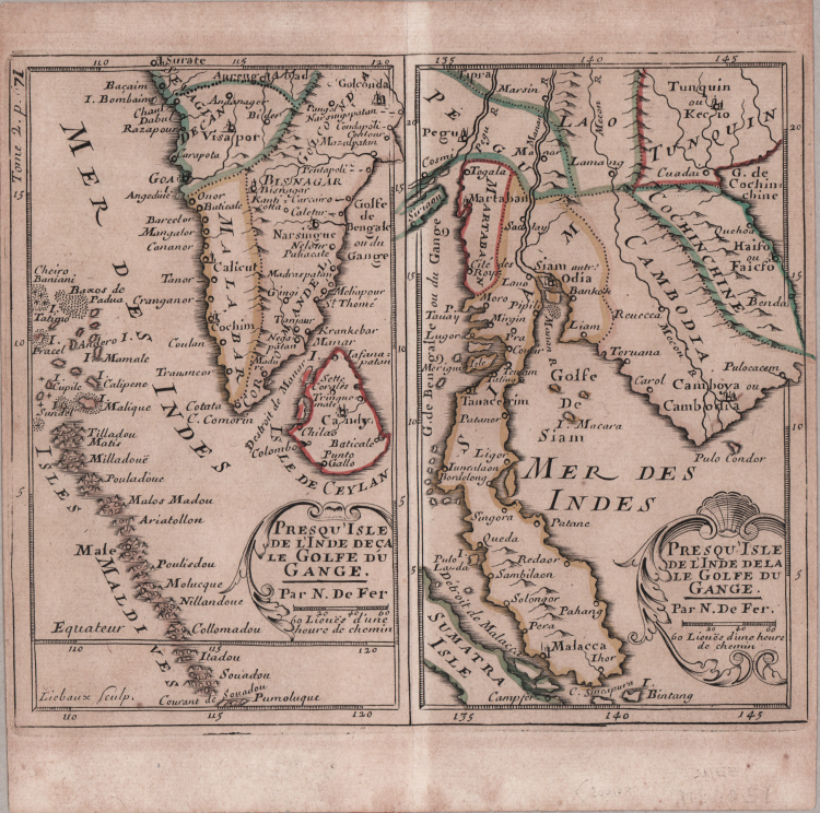
Two maps printed on one sheet. A delightful and rare map of the Indian peninsular with Ceylon and the Maldives on one sheet, and on the other Cambodia and the Malay peninsula, with part of Sumatra.
Copperplate with original outline colour, in good condition.
Nicolas DE FER (1646-1720 circa)
|
One of the most prolific and influential French geographers and cartographers of the late 17th and early 18th Century. Nicolas was the youngest son of Parisian print and mapseller, Antoine de Fer [d.1673]. He produced numerous atlases: Atlas Curieux [1700-5] and its subsequent suites; Atlas ou Receuil des Cartes [1709]; Atlas Royale [1699]; Les Beautés de la France [1708]; Atlases detailing wars and countries relating to the Spanish succession [1701]; Italy [1702] & Germany [1705] and Franco-Belgian frontiers [1708-10]; Les Forces de L'Europe [1690-95]; Introduction à la Géographie [1708]; the Petit Nouveau Atlas [1697]. Aswell as his Atlas output de Fer is also well known for his large Wall maps, some 26 in total, aswell as large-scale town plans of European cities, and a signifcant output of thematic printed card games. His sign and emblem was the Sphère Royale, originally that of Melchior Tavernier, to which he was greatly attached and which appears on a large number of his works. He died on 25th October 1720 and his estate was divided between his three daughters, all three of whose husbands were closely involved in the Parisian engraving and publishing business : Guillaume Danet, Remi Richer, Jaques-Francois Besnard or Bénard. A number of de Fer's maps and atlases continued to be published by his heirs for another twenty or thirty years.
|