
| Reference: | MMS48D |
| Author | Maurille Antoine MOITHEY |
| Year: | 1785 |
| Zone: | The Americas |
| Printed: | Paris |
| Measures: | 740 x 520 mm |
| Reference: | MMS48D |
| Author | Maurille Antoine MOITHEY |
| Year: | 1785 |
| Zone: | The Americas |
| Printed: | Paris |
| Measures: | 740 x 520 mm |
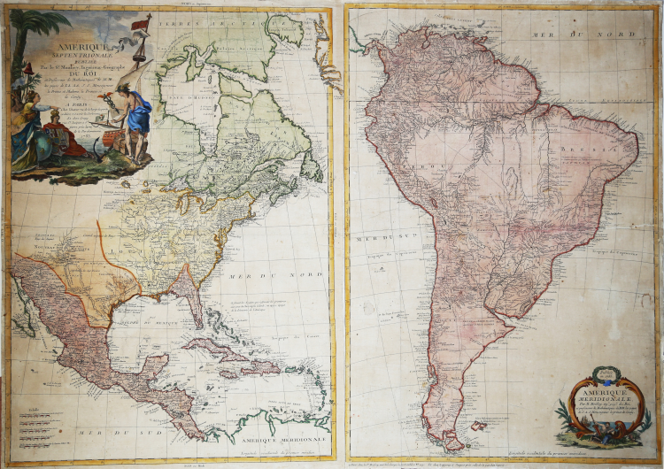
Amerique Septentrionale: Publiée par le sr. Moithey, ingénieur-géographe du Roi, et professeur de mathématiques de M M les pages de L.L. A.A. S.S. Monseigneur le Prince et Madame la Princesse de Conty par le Sr. Moithey
Amérique Meridionale par M.Moithey, ing. geog. du Roi et professeur de Mathematiques de MM. les pages de S. A. S. Monseigneur le prince de Conty
Fine first edition of the engraved wall map of North and South America by Maurille Antoine Moithey, published in Paris by Jean-Baptiste Crépy.
Map of North and South America, issued both together and individually. Extremely rare wall map showing both North and South America, with historiated cartouches.
The exquisitely colored cartouche upper left ("Amerique Septentrionale") is surrounded by allegorical figures, with Mercury and three female figures representing France (decorated with fleurs-de-lis), Spain (holding a coat of arms), and the newly formed United States (holding aloft a liberty cap on a staff). Mercury (with his winged helmet) stands upon a rock where a ship is setting anchor. "Amérique Septentrionale" shows Spanish raids in nice detail, and a trace of the Longue River is still shown in the Upper Midwest, here called the Grande Riviere.
Amerique Meridionale shows a detailed South America with an extensive system of rivers. The title cartouche contains a sea god holding an urn pouring water to represent the rivers, and a ship in the background. "Amérique méridionale" is largely based on d'Anville's 3-sheet map of 1748. This map shows highly developed river systems, but only rudimentary marking of mountain ranges. There are occasional geographical and historical notes, as well as numerous designations of Indian tribal and placenames. It is shown in irregular stereographic projection, with Ferro as prime meridian.
Maurille Antoine Moithey (1732 - 1810) was a French mathematician, cartographer, globemaker, game designer, and bookseller active in Paris in the mid to late 18th century. Moithey was born in Paris. He held the post of 'Ingénieur géographe du Roi' and professor of mathematics to the pages of the Prince and Princess of Conti. Throughout his long career as a geographer, he was an ardent spokesman for the 'freedom of the seas', particularly as applied to the English Channel.
Jean-Baptiste Crépy (fl. c. 1730 - 1796), also spelled Creepy, was a French map and print publisher based in Paris during the middle of the 18th century. His father Etienne-Louis Crépy, son of Jean Crépy (1660-1739). Within the family dynasty Jean-Baptiste was known as Crépy le Jeune, or Crépy the Younger. His work ranged from maps, such as his reprint of the Le Rouge issue of the Popple Key Map, to general prints, and even geographically themed board games. He is known to have worked with other French mapmakers of the period including André Basset. maintained offices at Rue St. Jacques a St. Pierre near la Rue de la Parcheminerie. The Crépy firm went into bankruptcy and liquidated at auction on the 24th of April, 1790. Jean-Baptiste Crépy died in 1796.
Etching with fine original colouring with retouches, printed on one sheet of contemporary laid paper, laid down on late 19th Century paper, small restored tears, slight oxidation, otherwise very good condition. Extremely rare.
Bibliografia
John R. Sellers & Patricia Molen Van Ee, Maps and Charts of North America and the West Indies 1750-1789, n. 196; The Lowery collection: a descriptive list of maps of the Spanish possessions within the present limits of the United States, 1502-1820, n. 666.
Maurille Antoine MOITHEY (Parigi, 1732-1810)
|
Maurille Antoine Moithey (1732 - 1810) was a French mathematician, cartographer, globemaker, game designer, and bookseller active in Paris in the mid to late 18th century. Moithey was born in Paris. He held the post of 'Ingénieur géographe du Roi' and professor of mathematics to the pages of the Prince and Princess of Conti. Throughout his long career as a geographer, he was an ardent spokesman for the 'freedom of the seas', particularly as applied to the English Channel.
|