| Reference: | s34865 |
| Author | Nicolas DE FER |
| Year: | 1700 ca. |
| Zone: | Venice |
| Printed: | Paris |
| Measures: | 338 x 225 mm |
| Reference: | s34865 |
| Author | Nicolas DE FER |
| Year: | 1700 ca. |
| Zone: | Venice |
| Printed: | Paris |
| Measures: | 338 x 225 mm |
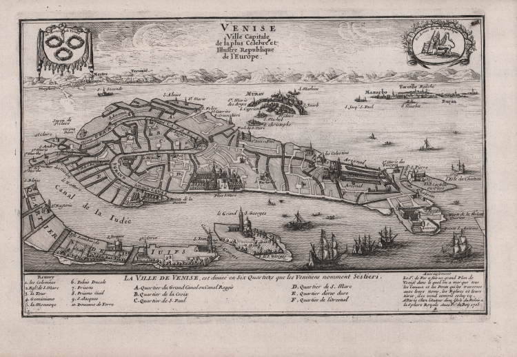
Delightful bird's-eye plan of the city and surrounding islands with great detail of major buildings.
The plan was reduced from De Fer's large chart of 1695 that he prepared for the Depot de la Marine.
A variety of ships and boats fill the lagoon and the arms of the city and the Venetian Republic decorate the plan. A key at bottom identifies ten sites and six districts.
Taken from the Atlas Curiex ou le Monde réprésenté dans des cartes générales et particuliéres du ciel et de la terre divisé tant en ses quatre principales parties que par états et provinces et orné par des plans et descriptions des villes capitales et principales[…], published in Paris in 1705.
Copper etching, in very good condition.
Nicolas DE FER (1646-1720 circa)
|
One of the most prolific and influential French geographers and cartographers of the late 17th and early 18th Century. Nicolas was the youngest son of Parisian print and mapseller, Antoine de Fer [d.1673]. He produced numerous atlases: Atlas Curieux [1700-5] and its subsequent suites; Atlas ou Receuil des Cartes [1709]; Atlas Royale [1699]; Les Beautés de la France [1708]; Atlases detailing wars and countries relating to the Spanish succession [1701]; Italy [1702] & Germany [1705] and Franco-Belgian frontiers [1708-10]; Les Forces de L'Europe [1690-95]; Introduction à la Géographie [1708]; the Petit Nouveau Atlas [1697]. Aswell as his Atlas output de Fer is also well known for his large Wall maps, some 26 in total, aswell as large-scale town plans of European cities, and a signifcant output of thematic printed card games. His sign and emblem was the Sphère Royale, originally that of Melchior Tavernier, to which he was greatly attached and which appears on a large number of his works. He died on 25th October 1720 and his estate was divided between his three daughters, all three of whose husbands were closely involved in the Parisian engraving and publishing business : Guillaume Danet, Remi Richer, Jaques-Francois Besnard or Bénard. A number of de Fer's maps and atlases continued to be published by his heirs for another twenty or thirty years.
|