| Reference: | s29440 |
| Author | Henri Abraham CHATELAIN |
| Year: | 1708 ca. |
| Zone: | Venice |
| Printed: | Paris |
| Measures: | 450 x 380 mm |
| Reference: | s29440 |
| Author | Henri Abraham CHATELAIN |
| Year: | 1708 ca. |
| Zone: | Venice |
| Printed: | Paris |
| Measures: | 450 x 380 mm |
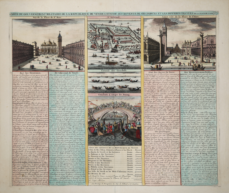
This full folio sheet features five engraved scenes in Venice. The views include Vue de la Palace de St. Marc, L'Arcenal, which is a bird's-eye plan, Autre vue de al Place de St. Marc, Course des Gondole's and a terrific close up view of gondolas with crowds of people on the bridge above.
The extensive text discusses the organization of Venice, its revenues, armies, life, major edifices, etc.
Henri Abraham Chatelain (1684 - 1743) was a Huguenot pastor of Parisian origins. He is best known as a Dutch cartographer and more specifically for his cartographic contribution in the seminal seven volume Atlas Historique, published in Amsterdam between 1705 and 1720. Innovative for its time, the Atlas Historique combined fine engraving and artwork with scholarly studies of geography, history, ethnology, heraldry, and cosmography. Some scholarship suggests that the Atlas Historique was not exclusively compiled by Henri Chatelain, as is commonly believed, but rather was a family enterprise involving Henri, his father Zacharie and his brother, also Zacharie.
Henri Abraham CHATELAIN (1684 - 1743)
|
Henri Abraham Chatelain (1684 - 1743) was a Huguenot pastor of Parisian origins. He is best known as a Dutch cartographer and more specifically for his cartographic contribution in the seminal seven volume Atlas Historique, published in Amsterdam between 1705 and 1720. Innovative for its time, the Atlas Historique combined fine engraving and artwork with scholarly studies of geography, history, ethnology, heraldry, and cosmography. Some scholarship suggests that the Atlas Historique was not exclusively compiled by Henri Chatelain, as is commonly believed, but rather was a family enterprise involving Henri, his father Zacharie and his brother, also Zacharie. The Atlas Historique published by Chatelain was part of a major work of its time, an encyclopaedia in seven volumes including geography as one of its main subjectes. The text was by Nicholas Gueudeville and the maps by Chatelain. The Atlas included one of the finest maps of America (4 sheets) surrounded by vignettes and decorative insets.
1705-20 Atlas Historique:Amsterdam (maps by Chatelain based on G.Delisle)
Further issues to 1739
|