
| Reference: | S2198 |
| Author | Johannes JANSSONIUS |
| Year: | 1640 ca. |
| Zone: | Padova |
| Printed: | Amsterdam |
| Measures: | 490 x 385 mm |
| Reference: | S2198 |
| Author | Johannes JANSSONIUS |
| Year: | 1640 ca. |
| Zone: | Padova |
| Printed: | Amsterdam |
| Measures: | 490 x 385 mm |
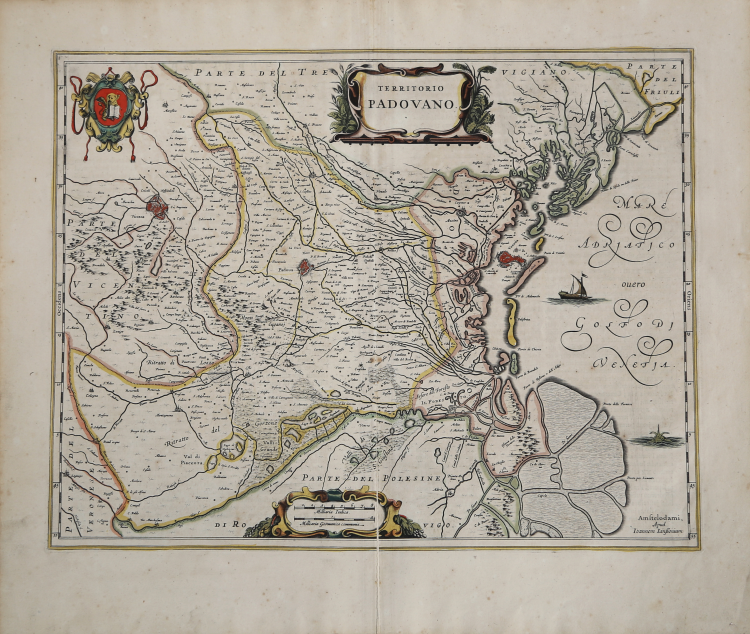
Map of the territory of Padua, taken from the Latin edition of Atlas Major by Janssonius.
First included in the Atlas sive cosmographicae meditationes de fabrica mundi edited by Hendrick Hondius and based on the work by Giovanni Antonio Magini.
In 1604, Jodocus Hondius (1563-1612) – probably trought Cornelis Claesz - bought the copperplates of Mercator’s Atlas sive cosmographicae meditationes de fabrica mundi at the auction of Gerard Jr.’s effects. He added about 40 maps, including new maps of the Continents and important regional maps of the Americas, before publishing a new edition of the Atlas, in 1606, in competition with Ortelius’ Theatrum Orbis Terrarum. As many of the maps were more up-to-date, the Mercator-Hondius Atlas effectively superseded Ortelius’ Theatrum. This atlas from 1606 include all 107 maps from the 1595 edition, as well as 37 new maps, skillfully engraved by Hondius, of various authors.
The second edition of the Mercator-Hondius atlas followed as soon as 1607/08. The first edition in another language, French, was put on the market in 1609. Apparently this one was regarded as the third edition, because in 1611 Editio Quarta appeared with a total of 150 maps. After the death of Jodocus Hondius in 1612 his widow and sons continued the publication of the Atlas. For instance Jodocus Junior (1594-1629) produced several new editions of the Editio Quarta between 1613 and 1619, each with the same 150 maps. Finally in 1619 the last edition of this atlas followed, to which six new maps were added. After 1620 the publication of the Atlas was continued by Henricus Hondius (ca. 1596/97-1651), the second son of Jodocus senior. Various editions appeared, in 1623, 1628 and 1630. Henricus Hondius was the first to make some real changes: in the 1628 edition he provided some Mercator maps with his own name. In 1630, when he was probably already cooperating with his brother-in- law Johannes Janssonius, Henricus added nine new maps.
Copperplate, fine original colouring, good condition.
|
Van der Krogt 1, 7120:1.2.
|
Johannes JANSSONIUS (1588-1664)
|
Johannes Janssonius, more commonly known to us as Jan Jansson, was born in Arnhem where his father was a bookseller and publisher (Jan Janszoon the Elder). In 1612 he married the daughter of the cartographer and publisher Jodocus Hondius, and then set up in business in Amsterdam as a book publisher. In 1616 he published his first maps of France and Italy and from then onwards he produced a very large number of maps, perhaps not quite rivalling those of the Blaeu family but running a very close second in quantity and quality. From about 1630 to 1638 he was in partnership with his brother-in-law, Henricus Hondius, issuing further editions of the Mercator/Hondius atlases to which his name was added. On the death of Henricus he took over the business, expanding the atlas still further, until eventually he published an 11-volume Atlas Major on a scale similar to Blaeu's Atlas Major.
The first full edition of Jansson's English County Maps was published in 1646 but some years earlier he issued a number of British maps in the Mercator/Hondius/Jansson series of atlases (1636-44); the maps were printed from newly engraved plates and are different from the later 1646 issue and are now rarely seen (see Appendix B for further details).
In general appearance Jansson's maps are very similar to those of Blaeu and, in fact, were often copied from them, but they tend to be more flamboyant and, some think, more decorative.
After Jansson's death his heirs published a number of maps in an Atlas Contractus in 1666 and later still many of the plates of his British maps were acquired by Pieter Schenk and Gerard Valck, who published them again in 1683 as separate maps.
|
|
Van der Krogt 1, 7120:1.2.
|
Johannes JANSSONIUS (1588-1664)
|
Johannes Janssonius, more commonly known to us as Jan Jansson, was born in Arnhem where his father was a bookseller and publisher (Jan Janszoon the Elder). In 1612 he married the daughter of the cartographer and publisher Jodocus Hondius, and then set up in business in Amsterdam as a book publisher. In 1616 he published his first maps of France and Italy and from then onwards he produced a very large number of maps, perhaps not quite rivalling those of the Blaeu family but running a very close second in quantity and quality. From about 1630 to 1638 he was in partnership with his brother-in-law, Henricus Hondius, issuing further editions of the Mercator/Hondius atlases to which his name was added. On the death of Henricus he took over the business, expanding the atlas still further, until eventually he published an 11-volume Atlas Major on a scale similar to Blaeu's Atlas Major.
The first full edition of Jansson's English County Maps was published in 1646 but some years earlier he issued a number of British maps in the Mercator/Hondius/Jansson series of atlases (1636-44); the maps were printed from newly engraved plates and are different from the later 1646 issue and are now rarely seen (see Appendix B for further details).
In general appearance Jansson's maps are very similar to those of Blaeu and, in fact, were often copied from them, but they tend to be more flamboyant and, some think, more decorative.
After Jansson's death his heirs published a number of maps in an Atlas Contractus in 1666 and later still many of the plates of his British maps were acquired by Pieter Schenk and Gerard Valck, who published them again in 1683 as separate maps.
|