| Reference: | s26651 |
| Author | Willem BARENTSZ & Johannes JANSSONIUS |
| Year: | 1654 |
| Zone: | Andalusia |
| Printed: | Amsterdam |
| Measures: | 520 x 375 mm |
| Reference: | s26651 |
| Author | Willem BARENTSZ & Johannes JANSSONIUS |
| Year: | 1654 |
| Zone: | Andalusia |
| Printed: | Amsterdam |
| Measures: | 520 x 375 mm |
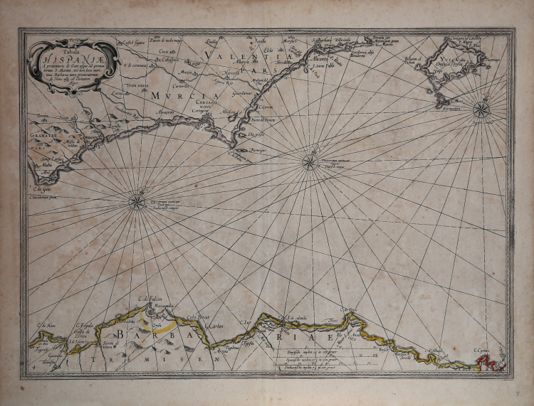
Tabula Hispaniae a Promontoro de Gato usque ad promontorium S. Martini, nec non loca maritima Barbariae intra promontoriuim de Non usq ad Civitatem Alger.
Nice example of the Janssonius edition of Barentsz sea chart, including Ibiza, the coast of Spain from Capo de Gata to Alicante and contiguous coastline of Algeria, which appeared in Jansson's Descriptio Maris Mediterranei, per tabula hydographics & geographicas . . ., published in Amsterdam in 1654. The map is a later re-issue of Barentsz map, with Jansson having completely changed the title and reworked the decorative embellishments, removing many of the great images originally added by Barentsz.
Willem Barentsz (1550 - 1597), Dutch cartographer and explorer, was one of the great pioneers of Arctic exploration. His first major work was the Caertboeck vande Midlandtsche Zee, the first nautical atlas devoted to the Mediterranean, which he published together with Petrus Plancius. Barentsz, however, is best remembered for his Arctic explorations. In 1553 - 1554, English adventurers Sir Hugh Willoughby and Richard Chancellor had attempted to find a route to Asia through Siberia. While their mission proved unsuccessful, accounts of the journey convinced many in Amsterdam of the existence of a passage to the northeast. Barentsz led three research expeditions: the first voyage, in June 1594, left Texel for the Kara Sea. The ships reached the coast of Novaya Zemlya and followed it northward but were eventually forced to turn back. The second expedition (1595), financed by Prince Maurice of Orange, also proved unsuccessful because of the unusually frozen Kara Sea. The third expedition in 1596 was the last attempt to claim the prize offered for the discovery of the passage by the Dutch States-General. The expedition discovered Spitsbergen in the Svalbard archipelago, and eventually reached Novaya Zembla on July 17. Barentsz's ship was, then, blocked by ice, and shortly afterward Barentsz lost his life. One of the ships returned to Amsterdam in November 1597; several crew members wrote accounts of the voyage. In 1871 Norwegian Captain Carlsen found the crumbling remains of the house that Barentsz had built for himself as a wintering station in Novaja Zemlja and transported with him the precious and, largely intact, relics that are now preserved Navy Museum in The Hague. The name Barentsz Sea has stuck to the part of the Ice Sea insinuated between the northern European coast, Novaja Zemlja, Franz Joseph Land and Svalbard, while Barentsz Island is called one among the eastern islands of Svalbard.
Jan Janssonius (also known as Johann or Jan Jansson or Janszoon) (1588-1664) was a renowned geographer and publisher of the seventeenth century, when the Dutch dominated map publishing in Europe. Born in Arnhem, Jan was first exposed to the trade via his father, who was also a bookseller and publisher. In 1612, Jan married the daughter of Jodocus Hondius, who was also a prominent mapmaker and seller. Jonssonius’ first maps date from 1616.
In the 1630s, Janssonius worked with his brother-in-law, Henricus Hondius. Their most successful venture was to reissue the Mercator-Hondius atlas. Jodocus Hondius had acquired the plates to the Mercator atlas, first published in 1595, and added 36 additional maps. After Hondius died in 1612, Henricus took over publication; Janssonius joined the venture in 1633. Eventually, the atlas was renamed the Atlas Novus and then the Atlas Major, by which time it had expanded to eleven volumes. Janssonius is also well known for his volume of English county maps, published in 1646.
Janssonius died in Amsterdam in 1664. His son-in-law, Johannes van Waesbergen, took over his business. Eventually, many of Janssonius’ plates were sold to Gerard Valck and Pieter Schenk, who added their names and continued to reissue the maps.
Bibliografia
G. Schilder, Monumenta Cartographica Neerlandica, Vol. VII, Alphen aan den Rijn, 2003, pp. 133-144; G. Schilder, Early Dutch Maritime Cartography. The North Holland School of Cartography (c. 1580-1620), Leida-Boston, 2017, pp. 197-213, ill. 6.17.
Willem BARENTSZ & Johannes JANSSONIUS (1550 - 1597)
|
Willem Barentsz (1550 - 1597), Dutch cartographer and explorer, was one of the great pioneers of Arctic exploration. His first major work was the Caertboeck vande Midlandtsche Zee, the first nautical atlas devoted to the Mediterranean, which he published together with Petrus Plancius. Barentsz, however, is best remembered for his Arctic explorations. In 1553 - 1554, English adventurers Sir Hugh Willoughby and Richard Chancellor had attempted to find a route to Asia through Siberia. While their mission proved unsuccessful, accounts of the journey convinced many in Amsterdam of the existence of a passage to the northeast. Barentsz led three research expeditions: the first voyage, in June 1594, left Texel for the Kara Sea. The ships reached the coast of Novaya Zemlya and followed it northward but were eventually forced to turn back. The second expedition (1595), financed by Prince Maurice of Orange, also proved unsuccessful because of the unusually frozen Kara Sea. The third expedition in 1596 was the last attempt to claim the prize offered for the discovery of the passage by the Dutch States-General. The expedition discovered Spitsbergen in the Svalbard archipelago, and eventually reached Novaya Zembla on July 17. Barentsz's ship was, then, blocked by ice, and shortly afterward Barentsz lost his life. One of the ships returned to Amsterdam in November 1597; several crew members wrote accounts of the voyage. In 1871 Norwegian Captain Carlsen found the crumbling remains of the house that Barentsz had built for himself as a wintering station in Novaja Zemlja and transported with him the precious and, largely intact, relics that are now preserved Navy Museum in The Hague. The name Barentsz Sea has stuck to the part of the Ice Sea insinuated between the northern European coast, Novaja Zemlja, Franz Joseph Land and Svalbard, while Barentsz Island is called one among the eastern islands of Svalbard.
|