| Reference: | S377650 |
| Author | Frederick de WIT |
| Year: | 1675 ca. |
| Zone: | Pacific Ocean |
| Printed: | Amsterdam |
| Measures: | 571 x 495 mm |
| Reference: | S377650 |
| Author | Frederick de WIT |
| Year: | 1675 ca. |
| Zone: | Pacific Ocean |
| Printed: | Amsterdam |
| Measures: | 571 x 495 mm |
Nice example of this sea chart from De Wit's Orbis Maritimus ofte Zee Atlas.
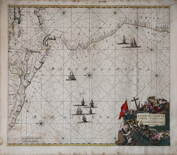
The map covers the Pacific Coast from Xalisco, Mexico to Puerta Bairres and Rio Cachapool in Chile, covering over two thirds of the Chilean Coast. In the Caribbean, all of the Yucatan and parts of Cuba and Hispaniola are shown, along with all of Jamaica and the Caymans. Nice detail throughout Central America. Columbia is shown in its entirety, along with a small piece of Venezuela. Includes well over 100 place names in classic Portolano style, along with gorgeous allegorical cartouche, 8 sailing ships and two compass roses.
Nice example of this marvelous sea chart, later copied in the 18th Century by Renard (1715) and Ottens (1745).
Frederick de WIT (1630 - 1706)
|
De Wit was one of the most prominent and successful map engravers and publishers in Amsterdam in the period following the decline of the Blaeu and Jansson establishments, from which he acquired many copper plates when they were dispersed at auction. His output covered most aspects of map making: sea charts, world atlases, an atlas of the Netherlands, 'town books' covering plans of towns and cities in the Netherlands and Europe, and wall maps. His work, notable for the beauty of the engraving and colouring, was very popular and editions were issued many years after his death by Pieter Mortier and Covens and Mortier.
|