| Reference: | OS6 |
| Author | Pirro LIGORIO |
| Year: | 1552 |
| Zone: | Rome |
| Printed: | Rome |
| Measures: | 545 x 400 mm |
| Reference: | OS6 |
| Author | Pirro LIGORIO |
| Year: | 1552 |
| Zone: | Rome |
| Printed: | Rome |
| Measures: | 545 x 400 mm |
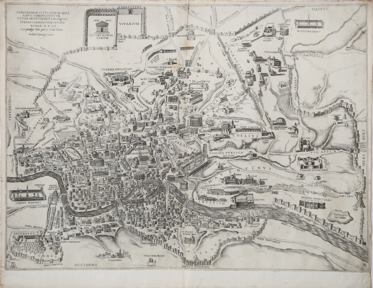
Etching and engraving, 1552.
A very rare early map of the city, designed by Pirro Ligorio and engraved by George Lily for the publisher Michele Tramezzino, who obtained the privilege of printing from the Senate of Venice on December 19, 1552.
Ligorio based his work on the map of Bufalini of the previous year (1551), from which derives both the wall layout and the orography. However, it raises the point of view, so that the main buildings and monuments can be represented in elevation perspective.
The map of Ligorio constitutes the model for the representation of the city, taken up for over a century also by publishers of northern Europe. Fransz Hogenberg realizes a faithful copy, adding only the three characters in the foreground on the right, for the first volume of the Civitates Orbis Terrarum (1572).
In the upper left corner: "URBIS ROMAE SITUS CUM IIS QUAE ADHUC CONSPICIUNTUR VETER MONUMENT REQUILIIS PYRRHO LIGORIO NEAP. INVENT ROME M.D.LII Cun privilege Su[m]mi pont. et Senat. Venet. Michaelis Tramezini Formis".
In the lower left corner we find the monogram G. L. A. that identifies the engraver of the plate.
Orientation on the four sides with the name of the cardinal points: SEPTENTRIO, MERIDIES, ORIENS, OCCIDENS, the north is on the left.
Much confusion has been generated in the past around the interpretation of the GLA monogram, reported by Nagler but without attribution. Frutaz suggests Girolamo Agucchi but there is no doubt that it is the acronym of Georgius Lillius Anglus, originally George Lily, former author of the British Isles map for the Tramezzino.
Magnificent proof, printed on contemporary laid paper with watermark "arrows crossed with star" (Woodward nn. 193-201), with small margins, in excellent condition.
Only 13 specimens of the plant are known in public collections around the world: Atlante Doria; Berlino, Kupferstichkabinet; Chicago, Newberry Library; Darmstadt Universitäts und Landesbibliothek; Londra, British Library (2); Monaco di Baviera, Bayerische Staatsbibliothek; Parigi, Bibliothèque Nationale; Roma, Biblioteca di Archeologia e Storia dell’Arte; Roma, Biblioteca Nazionale; Stoccolma, National Library of Sweden; Wolfegg, Bibliothek Schloss (cf. B/R p. 2373).
Literature
Bifolco - Ronca, Cartografia e Topografia italiana del XVI secolo (2018), pp. 2373-2374, tav. 1222; Destombes (1970): n. 99; Ruge (1904-16): IV, n. 87.50; Sotheby’s (2005): n. 70; Benevolo (1969): pp. 99-107, tav. XXIII; Fauser (1978): vol. 2, p. 688, n. 11900; Frutaz (1962): n. CXI e tav. 222; Hülsen (1915): II, p. 42, n. 10; Hülsen (1933): p. 104, n. 11; Karrow (1993): n. 51/1; Nagler (1881): vo. 3, n. 140; Scaccia Scarafoni (1939): p. 82, n. 143; Tooley (1939): n. 484.
|
Bifolco - Ronca, Cartografia e Topografia italiana del XVI secolo (2018), pp. 2373-2374, tav. 1222.
|
Pirro LIGORIO (Napoli 1510 - Ferrara 1583)
|
Pirro Ligorio (or Liguori) architect, antiquarian, topographer was born in Naples in 1510.
In 1533 he moved to Rome, where he began his artistic career. An architect of genius, a great connoisseur of antiquities of Rome and the Roman countryside, as an archaeologist and surveyor collected a large number of drawings and historical information - art. He knows of a map of Rome published in 1552 and reprinted in 1570, a plant small archaeological Rome edited by Sandwich in 1553. In 1561 creates the largest archaeological map of Rome, in twelve sheets, engraved by Bos, edited by Michele and Francesco sandwich. As for the mapping part is I know very few cards, all recorded by Sebastian King and published in Rome by Michele sandwich. These include the Nova Descriptio Neapolitans Kingdoms (1557), Totius Galliae Descriptio (1558), copper Duchet passed to him to edit his name in 1571, Nova Descriptio (1559), Nova Descriptio totius Hispaniae (1559), Greece (1561 ), Friuli (1563), while the Descriptio totius Galliae Belgica (1558), although its name shows, is nothing but a reproduction of the card Gilles Buillon. In 1568 he moved with his family in Ferrara, where he died in October 1583.
|
|
Bifolco - Ronca, Cartografia e Topografia italiana del XVI secolo (2018), pp. 2373-2374, tav. 1222.
|
Pirro LIGORIO (Napoli 1510 - Ferrara 1583)
|
Pirro Ligorio (or Liguori) architect, antiquarian, topographer was born in Naples in 1510.
In 1533 he moved to Rome, where he began his artistic career. An architect of genius, a great connoisseur of antiquities of Rome and the Roman countryside, as an archaeologist and surveyor collected a large number of drawings and historical information - art. He knows of a map of Rome published in 1552 and reprinted in 1570, a plant small archaeological Rome edited by Sandwich in 1553. In 1561 creates the largest archaeological map of Rome, in twelve sheets, engraved by Bos, edited by Michele and Francesco sandwich. As for the mapping part is I know very few cards, all recorded by Sebastian King and published in Rome by Michele sandwich. These include the Nova Descriptio Neapolitans Kingdoms (1557), Totius Galliae Descriptio (1558), copper Duchet passed to him to edit his name in 1571, Nova Descriptio (1559), Nova Descriptio totius Hispaniae (1559), Greece (1561 ), Friuli (1563), while the Descriptio totius Galliae Belgica (1558), although its name shows, is nothing but a reproduction of the card Gilles Buillon. In 1568 he moved with his family in Ferrara, where he died in October 1583.
|