
| Reference: | S5140 |
| Author | Giovanni Antonio MAGINI |
| Year: | 1596 |
| Zone: | Persia |
| Printed: | Venice |
| Measures: | 180 x 135 mm |
| Reference: | S5140 |
| Author | Giovanni Antonio MAGINI |
| Year: | 1596 |
| Zone: | Persia |
| Printed: | Venice |
| Measures: | 180 x 135 mm |
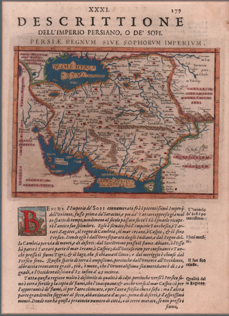
Map taken from the Geografia cioè descrittione universale della Terra of Claudio Tolomeo by Giovanni Antonio Magini, first printed in Venice in 1596, at the Heirs of Simon Galignani de Karera.
The Magini collection contains 64 copper engravings finely carved by Girolamo Porro and was soon copied by Petrus Keschedt, a publisher from Cologne (the maps of the two editions are almost indistinguishable).
A subsequent reprint of Magini's work, with the translation by Leonardo Cernoti from the Latin text, was printed in Padua by the Galignani brothers in 1621. With this edition of the Geografia “the long series of editions of Ptolemy’s Geography, revised and extended as text books of modern geography, seems to have come to an end” (Stevens, 1972, p. 22).
Copper engraving with fine later hand colour, in excellent condition.
Giovanni Antonio MAGINI (1555 - 1617)
|
Giovanni Antonio Magini was born in Padua in 1555, dedicating himself to the study of astronomy from an early age. In 1588 the Senate of Bologna appointed him Lecturer of Astronomy at the local University, choosing him instead of Galileo Galilei. His friendship with the Duke of Mantua, Vincenzo Gonzaga, helped Magini in his quest to obtain cartographical material for map-making from the various sovereigns ruling the different Italian states at that time. Because of Magini's early death in 1617, this effort was made famous by his son Fabio when he published the atlas "L'Italia" in Bologna in 1620. This is the first example of an Italian atlas and is made up of 24 pages of descriptive text and 61 maps of the Italian peninsula. Although this work was published posthumously, it can be entirely ascribed to Magini. He began drawing this maps around 1594, with the one depicting Bologna and its surrounding territories being the first. They were all printed before 1620 in draft editions which were then revised and updated for the final version. These draft proofs are extremely rare, although sometimes available for sale, and exhibit substantial differences in respect to the maps finally included in the atlas. Two of the most famous engravers of the time, Arnoldo Arnoldi and the englishman Benjamin Wright, were entrusted by Magini to engrave the plates. As we shall see in the presentation of the separate maps, they derive from different sources, both known and unknown, and therefore represent the result of an original work of critical analysis and compilation. This atlas had an important influence on the cartography of the italian peninsula for the following two centuries, beginning from Ortelius and going on to the principal dutch cartographers and editors.
|