
| Reference: | S37764 |
| Author | Frederick de WIT |
| Year: | 1680 ca. |
| Zone: | West Indies |
| Printed: | Amsterdam |
| Measures: | 572 x 490 mm |
| Reference: | S37764 |
| Author | Frederick de WIT |
| Year: | 1680 ca. |
| Zone: | West Indies |
| Printed: | Amsterdam |
| Measures: | 572 x 490 mm |
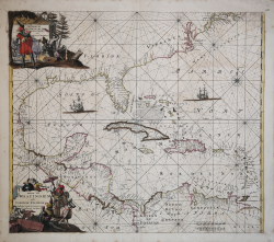
A fine and rare old color example of the second edition of Frederick de Wit's 1680 nautical chart or maritime map of the West Indies, Central America, Gulf of Mexico, and Florida.
Printed during the Golden Age of Caribbean Piracy, this sea chart covers the eastern coast of North America from Cape May and the Chesapeake Bay to Central America and the Spanish Main.
It offers a reasonably detailed depiction of the West India Islands, Florida, and Central America.
The American seaboard north of Florida is exaggerated in its northeasterly inclination, an error that would be corrected in the early 18th century. Similarly, the Yuchatan appears in a narrow configuration common in most Dutch maps until the late 18th century. Note the Mississippi River Delta has not yet been identified, but numerous place names along the coast are identified, if only conjecturally. The whole is filled with rhumb lines and illustrations of galleons. Cartographically the map was partially derived from Hessel's Gerritsz's map of 1631 with updates derived from Joannes van Loon's map of 1661.
This map was published in de Wit's Orbis Maritimus ofte Zee Atlas of 1680. It was engraved by Romeyn de Hooghe. The second edition can be identified by the presence of the western coast of Central America and the addition of New Amsterdam in the upper right quadrant. Two subsequent editions were issued by L. Renard and the Ottens family. All editions of this map are scarce.
Frederick de Wit (c. 1630 - 1706) was a cartographer and publisher, originally from Gouda. He moved to Amsterdam in 1648, studying under the Blaeu family, and in 1654 started his own business, opening a print shop under the sign "The Three Crabs," which he later changed to "The White Chart." In 1660 he published his map of the world, Nova Totius Terrarum Orbis Tabula, produced both as a wall map and as a reduction to an in-folio atlas format (see Shirley, The Mapping of the World, no. 444). Two years later he began printing atlases that were assembled essentially to the customer's requirements, some of which included more than 150 maps. After marrying Maria van der Way, a native of Amsterdam, de Wit obtained citizen privileges and became a member of the city guild of St. Luke's in 1664. In 1675 he published his lavish nautical atlas, Orbis Maritimus ofte Zee Atlas, also known for its elaborate decoration. In 1695, he published a book of city views of the Netherlands, Perfekte aftekeningen der steden van del XVII Nederlandsche provincien. After de Wit's death, his widow, Maria, continued the business until 1710. Their son, Franciscus, was a fish merchant and had no interest in the map store. The print shop was, therefore, sold at auction and most of the plates were purchased by Pieter Mortier. The 27 plates of his 1675 nautical atlas were later sold at auction in 1710 to the Amsterdam printer and bookseller Louis Renard, who published them under his own name and with some modifications in 1715.
Copperplate with fine original colour, light foxing, otherwise very good condition.
Bibliografia
Koeman Atlantes Neerlandici IV, pp.518-19; Burden, P, The Mapping of North America II, #468, State 2.
Frederick de WIT (1630 - 1706)
|
De Wit was one of the most prominent and successful map engravers and publishers in Amsterdam in the period following the decline of the Blaeu and Jansson establishments, from which he acquired many copper plates when they were dispersed at auction. His output covered most aspects of map making: sea charts, world atlases, an atlas of the Netherlands, 'town books' covering plans of towns and cities in the Netherlands and Europe, and wall maps. His work, notable for the beauty of the engraving and colouring, was very popular and editions were issued many years after his death by Pieter Mortier and Covens and Mortier.
|