| Reference: | s33965 |
| Author | Domenico Mariano Franceschini |
| Year: | 1739 |
| Zone: | Mexico |
| Printed: | Rome |
| Measures: | 245 x 183 mm |
| Reference: | s33965 |
| Author | Domenico Mariano Franceschini |
| Year: | 1739 |
| Zone: | Mexico |
| Printed: | Rome |
| Measures: | 245 x 183 mm |
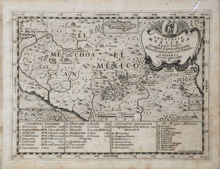
A very rare map of central area of Mexico, with Carmelite convents, engraved by Domenico Franceschini.
The map shows the province established in 1588 by the Spanish Congregation of the Order of Discalced Carmelites and dedicated to Sant 'Alberto, whose image surmounts the cartouche with the title.
In 1588, the Congregation was divided in six provinces plus Mexico (Castilla la Vieja, Castilla la Nueva, Andalucia la Alta, Andalucia la Baja, Aragon and Portugal). Then, the Order expanded throughout Europe and the congregations of Portugal and Italy were created but the three congregations remained independent from each other.
The map is part of the work Provinciarum et Conventuum Fratum, ac monalium Discalceatorum Ordinis B Virginis Mariae de monte Carmelo Congregationis Hispaniae Corographica Topographica, et Chronologica Descriptio" edited in Rome in 1739.
Graduated borders, scale in the Spanish miles - Scala Leucarum Hispaniae (40 miles = 4.5 cm), the topography is represented with the design of the mountains from the shaded profile; It is also reported the hydrography, indicating the names of the waterways.
In the lower margin, alphabetical and numerical legends respectively, with the references to the Convents of Friars (Conventus Fratrum) and those Carmelite nuns (conventus monalium).
Copperplate, with margins, a small wormhole in the upper margins, light foxing, otherwise perfect condition.
Domenico Mariano Franceschini (fl. 1700-1730)
Domenico Mariano Franceschini (fl. 1700-1730)