
| Reference: | S32625 |
| Author | Jacques Nicolas BELLIN |
| Year: | 1757 |
| Zone: | East Coast |
| Printed: | Paris |
| Measures: | 285 x 185 mm |
| Reference: | S32625 |
| Author | Jacques Nicolas BELLIN |
| Year: | 1757 |
| Zone: | East Coast |
| Printed: | Paris |
| Measures: | 285 x 185 mm |
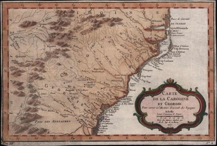
This is French cartographer Jacques-Nicholas Bellin’s 1757 map of the Carolinas and Georgia. It covers modern day North Carolina, South Carolina and Georgia, and parts of Virginia and eastern Tennessee, extending from just north of the Albemarle Sound south to Jekyll Island in Georgia and inland as far as the Appalachians and beyond. Important early cities and towns are depicted, including Savannah, Georgetown, Charles Town, Augusta, Edenton, etc. are identified.
Most likely based on an earlier 1752 map by Emanuel Bowen, this map exhibits the early course of the Tennessee (Callamaco) River is depicted. The coastlands are well settled and exhibit considerable European development, however, only a short distance inland European settlements quickly give way to unexplored lands and the territories claimed by powerful American Indian nations, particularly west of the Appalachian Mountains.
This map was drawn by Jacques Nicolas Bellin and published as plate no. 11 in volume 9 of the 1757 French edition of Abbe Provost's L'Histoire Generale des Voyages.
Bellin was one of the most important cartographers of the 18th century; he was born in Paris, and was a member of the Académie de Marine and the Royal Society of London. In 1721, at the age of 18, he was appointed hydrographer (chief cartographer) to the French Navy. In August 1741, he became the first Ingénieur de la Marine of the Depot des cartes et plans et de la Marine (the French hydrographic office) and was appointed hydrographic officer to the King of France. During his service he was commissioned to survey first the French coastline and later those of the entire known world. His output was immense, and his high-quality nautical charts appeared in multiple editions beyond the end of the 18th century.
Jacques Nicolas BELLIN (1703 - 1772)
|
Jacques-Nicolas Bellin (1703 - 1772) was one of the most important cartographers of the 18th century.
With a career spanning some 50 years, Bellin is best understood as transitional mapmaker spanning the gap
between 18th and early 19th century cartographic styles. His long career as Hydrographer and Ingénieur
Hydrographe at the French Dépôt des cartes et plans de la Marine resulted in hundreds of high quality
nautical charts of practically everywhere in the world. Bellin's work focuses on function and accuracy
tending in the process to be less decorative than the earlier 17th and 18th century cartographic work. In
addition to numerous maps and charts published during his lifetime, many of Bellin's maps were updated
(or not) and published posthumously. He was succeeded as Ingénieur Hydrographe by his student, also a prolific and influential cartographer, Rigobert Bonne.
|