
| Reference: | S40320 |
| Author | Claudio DUCHET (Duchetti) |
| Year: | 1585 |
| Zone: | Naples |
| Printed: | Rome |
| Measures: | 513 x 380 mm |
| Reference: | S40320 |
| Author | Claudio DUCHET (Duchetti) |
| Year: | 1585 |
| Zone: | Naples |
| Printed: | Rome |
| Measures: | 513 x 380 mm |
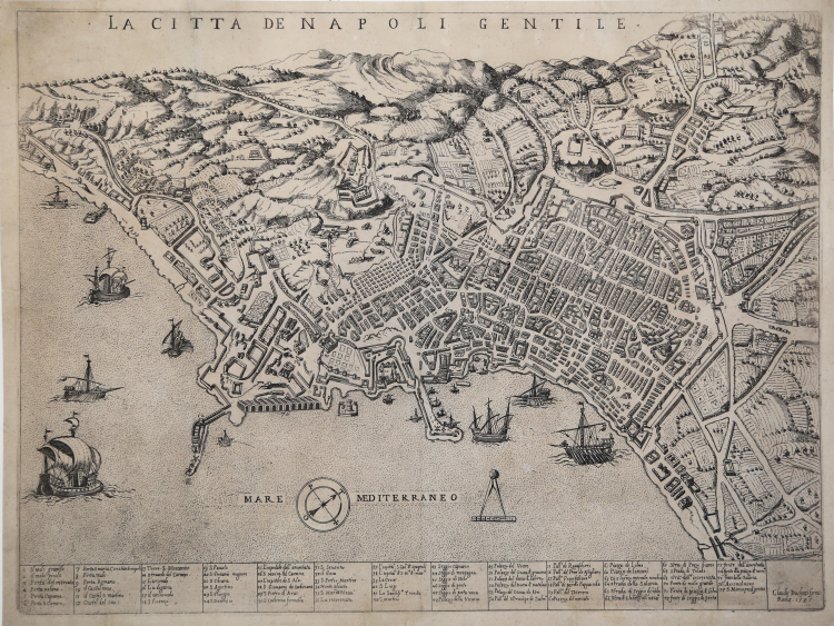
In the upper center, below the top margin, is engraved the title: LA CITTA DE NAPOLI GENTILE. Along the lower margin we find a numerical legend of 77 references to notable places and monuments spread over thirteen columns. This is followed by the imprint Claudij Duchetti formis Romae 1585. In the center of the map, in the sea, a schematic wind rose; the North-Northeast, to the right.
Example in the first state of two, printed by Claudio Duchetti in 1585, and before the Giovanni Orlandi address.
Claudio Duchetti's plan of Naples represents an approximate derivation of the model that his uncle Antonio Lafreri had engraved by Etienne Duperac in 1566. The engraving is attributed by Destombes to Ambrogio Brambilla. It is, however, an execution not very faithful to the original, more approximate and with an elongation of about 5 millimeters with respect to the adopted metrical scale (about1: 9,000). The correction of the repetition of the 41 references in the legend and the inclusion of the new arsenal lead one to think that Duchetti’s map is rather a copy of Mario Cartaro's plate (1579). After all, the two knew each other well, and they clashed on the occasion of the hereditary division of the Lafreri printing house, for which Cartaro was appointed surveyor. Compared to Cartaro's plan, two new references are added in the legend, for the arsenal and the church of Santa Maria di Piedigrotta. (cfr. Cartografia e topografia italiana del XVI secolo, p. 2256).
The plan of Naples, engraved in Rome in 1566 by Étienne Dupérac at the workshop of Antonio Lafreri, is the first true topographical monument of the city of Naples and is fully inserted, both for its technical and artistic qualities, in the broader scenario of sixteenth-century European urban iconography. For two centuries, it was considered the best representation of Naples: made with great geometric rigor, it is the first to be based on a precise topographical survey-unknown, probably carried out under the patronage of the Spanish Crown or viceroy Pedro de Toledo. This bird's-eye view accurately restores the face of the sixteenth-century city under the reign of Philip II, thus constituting a valuable document of the urban development that followed the initiatives promoted by Don Pedro de Toledo, author of the last public urban restructuring project in Naples. The image is made with great precision and detail, through the three-dimensional representation of the city's architecture, so much so that it became a prototype for engravers and editors throughout the seventeenth century. Great attention is given to the representation of the wall circuit, which constitutes the major urbanistic achievement/work in Naples until the 19th century. The decorative apparatus is very rich, with a baroque framed cartouche and numerous boats at sea and in the harbor. Among the peculiarities of the map should be noted the high scale (1:5110 ca) and its continuity in every part of the drawing, with the exception of the landscape perspectives towards the Phlegraean Fields. The plan, therefore, comes from a mighty topographical survey, perhaps also leaning on geometric triangulation, a technique already known at the time.
As mentioned, however, Duchetti was also inspired by the plan of Mario Cartaro (1579), which is not limited, however, to copying the Lafreri’s model, as the work is updated with some urbanistic changes. In fact, the warehouses of the new arsenal, work on which had begun in 1577, are represented; moreover, the new buildings dedicated to the Spanish troops that rose at the foot of San Martino are here more complete than in the original model. Cartaro’s map it0s the first to show in the title the adjective "gentile," with which the fifteenth-century chronicler Loise De Rosa qualified Naples. The qualification gentile is the most current in the Aragonese era among those reserved for the city: great, noble and beautiful.
Etching and engraving, impressed on contemporary laid virgin paper without watermark, with small margins, in very good condition.
Very rare plan, surveyed in very few examples institutional examples [Atlante Stevens-Beans-Nebenzahl; Chicago, Newberry Library; Londra, British Library; Madrid, Biblioteca Nacional; Malta, National Library;Parigi, Bibliotheque Nationale] (cfr. Cartografia e topografia italiana del XVI secolo, p. 2256).
Bibliografia
S. Bifolco, F. Ronca, Cartografia e topografia italiana del XVI secolo, tav. 1158, I/II; Destombes (1970): n. 81; De Seta (1969): vol. 1, pp. 128, 132 e tav. VII; Pane-Valerio (1988): pp. 81-83, n. 21; Tooley (1939): n. 412; Valerio (1998), Piante e vedute di Napoli dal 1486 al 1599, n. 20.
Claudio DUCHET (Duchetti) (Attivo a Roma nella seconda metà del XVI sec.))
|
Print dealer and publisher.Active in Venice 1565-1572 and Rome.He was the brother of Francesco Duchetti and a nephew of Antonio Lafrery, inheriting half his plates.
Died 5 December 1585.He was buried in San Luigi dei Francesi.By the terms of his will, his brother –in-law Giacomo Gherardi was to run the business until the majority of Claudio’s son, Claudio.
While Gherardi in charge, he was to inscribe the prints ‘haeredes Claudii Duchetti’.
He commissioned plates from among others Perret, Thomassin and Brambilla.
The name 'Lafreri-School' is a widely used, but rather inaccurate, term used to describe a loose grouping of cartographers, mapmakers, engravers and publishers working in the twin centres of Rome and Venice, from about 1544 to circa 1585. Earlier this century, George Beans, a prominent American collector of Italian maps and atlases, proposed the alternative name 'I.A.T.O.' to describe the composite collections assembled and sold by this school - 'Italian, Assembled-To-Order'. While more apposite, it has failed to catch on with modern cataloguers and collectors. For the purposes of this article, I intend to refer to the cartographers, engravers and publishers involved as "the school", although even this term implies a greater structure and organisation than can currently be established. The principal reference source on the work of the school is R.V. Tooley's Maps in Italian Atlases of the Sixteenth Century (1). In his study, published in 1939, Tooley listed some 614 maps and plates (with variant states counted separately). Some were described from personal examination, others noted from secondary sources and listings. While now much out-dated, as more recent regional carto-bibliographies have effectively superceded particular sections, and new collections have come to light, it remains the only overview of the output of the school. The principal cartographer of the school was Giacomo Gastaldi (fl. 1542-1565), a Piedmontese who worked in Venice, becoming Cosmographer to the Venetian Republic. Karrow described him as "one of the most important cartographers of the sixteenth century. He was certainly the greatest Italian mapmaker of his age..." (2). While his achievement is obvious, it is hard to quantify. A large number of maps were published throughout this period with the geography credited to Gastaldi, but it is often difficult to know what role Gastaldi played in their creation. As a practice, he did not sign himself as publisher, although his name may be found in the title, dedication, or text to the reader. Frequently where there is no imprint one may assume that Gastaldi was the publisher. A further clue may be that many of the maps attributable to Gastaldi as publisher seem to have been engraved by Fabius Licinius. In other cases, where publication is credited to another, it is not always certain whether Gastaldi was commissioned by the publisher to compile the map, whether another less-enterprising publisher merely copied his work and attribution, or simply added Gastaldi's name in the title to add authority to the delineation. His name clearly commanded the same sort of respect that the Sanson name had in the last years of the seventeenth century, and as Guillaume de l'Isle's had in the first half of the eighteenth century. Paolo Forlani was a cartographer and engraver who worked in Venice between 1560 and circa 1571. The majority of his output was published under the imprint of other publishers, such as Giovanni Francesco Camocio, Ferrando Bertelli and Bolognini Zaltieri. In a pioneering study, David Woodward (4), by identifying Forlani's engraving style through various stages of development, has attributed a large number of previously unidentified maps to his hand, and provided a clearer picture of some of the publishing arrangements of the period. In the early 1560s Giovanni Francesco Camocio published a number of maps that were drawn by Forlani, including maps of the World, North Atlantic, Africa, France, Switzerland, and provinces of the Low Countries, to note but a few. Circa 1570, Camocio published an Isolario, or collection of maps of islands, principally from the Mediterranean, but including the British Isles and Iceland. Camocio's earliest issues lacked a title-page, and tended to be a relatively random selection from the available stock. Later he added a title Isole Famose Porti, Fortezze E Terre Maritime. After his death, which is assumed to have been in 1573, the plates were reprinted, with a title-page bearing the Bertelli family address 'alla Libraria del Segno di S. Marco', possibly by Donato Bertelli, whose imprint is found on a later state of Camocio's world map of 1560. The largest grouping was the Bertelli family. The most active was Ferrando Bertelli, who flourished in the 1560's and 1570's, but maps from the last quarter of the seventeenth century are known with the imprints of Andrea, Donato, Lucca, Nicolo and Pietro. Again, a number of maps published by Ferrando were drawn or engraved by Forlani.
Antonio Salamanca (1500 – 1562) settled in Rome his chalcographical business; his activity was then carried on and enlarged by his scholar Antonio Lafrery (1512 – 1577), and then by his grand son Claudio Duchet (Duchetti), Giovanni Orlandi, Henrik van Schoel, and finally by De Rossi. In Venice, the most important centre of map production, he was initiated into engraving by Giovanni Andrea Vavassore and Matteo Pagano, who had worked with Giacomo Gastaldi, the most important European cartographer of the XVI century. Other important exponents of the Venetian chalcography were Fabio Licinio, Fernando Bertelli, Giovanni Francesco Camocio and above all of them Paolo Forlani. Although he’s better known as publisher of Roman archeology, Antoine de Lafrery, born in France, has been the publisher thathas given the biggest impulse to Roman chalcography, becoming in a few years an expert seller as well. For that reason, even though he’s not the one that has published most maps in his time, all the chalcographic works printed in Rome and Venice during the XVI century are nowadays defined as “charts of lafrerian school”. This definition was given by Adolf Erik Nordenskiold, one of the fathers of the history of cartography, who also introduced the definition of Lafrery Atlas, talking about charts printed in Rome and published by Lafrery, in which we find a sort of title page with the title Tavole moderne de geografia secondo l’ordine di Tolomeo. Lafrery’s school produced a huge amount of maps, usually selling them as separate charts and somehow and then edited in a bigger volume. Since the charts had all different measures, the artists needed to trim them with copper to get them to the same size, adding at the end estra pieces of paper, if necessary.
|