| Reference: | VR76 |
| Author | William FADEN |
| Year: | 1785 |
| Zone: | Mediterranean Sea |
| Printed: | London |
| Measures: | 1680 x 615 mm |
| Reference: | VR76 |
| Author | William FADEN |
| Year: | 1785 |
| Zone: | Mediterranean Sea |
| Printed: | London |
| Measures: | 1680 x 615 mm |
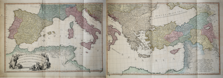
A large map of the Mediterranean Sea by Faden's General Atlas.
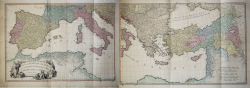
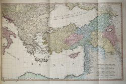
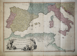
This is an appealing 1785 map of the Mediterranean region issued by William Faden. A set of two maps, the western sheet covers from Portugal, Spain, Italy, the Maghreb or the Barbary Coast of Africa and includes parts of France and the Balkans. The Spanish Islands of Minorca, Majorca and Ibiza are included, along with Corsica, Sardinia, Malta and Sicily. The eastern sheet extends from Croatia east as far as Iran and from Crimea south to Egypt’s Nile Delta, including the islands of Crete or Candia and Cyprus and the Black Sea. Covers the modern day Greece and Turkey in their entirety (including the area formerly known as Kurdistan), as well as Georgia, Armenia, Jordan, Israel, Palestine, Iran, Iraq, Syria, Ukraine and the Balkan nations. Color coded according to political territory, the map notes several important towns, rivers, cities, lakes, islands and mountains along with other topographic features. Depicts the Italian peninsula divided up in to various states and duchies. Jerusalem, Baghdad (Bagdad), Constantinople (the capital of the Roman Empire) and other important cities.
When this map was drawn this region was dominated by the waning Ottoman hegemony. The Ottomans would nevertheless continue to exert a powerful influence on this region until the early 19th century. The Barbary Coast was a hotbed of piracy – much like the Somali Coast today. The Barbary Pirates would attack trading ships passing through narrow Gibraltar straits and western Mediterranean. Ships would be destroyed or appropriated, cargo seized and the crew and passengers enslaved. By the early 19th century, piracy in this region had become so intense that the United States launched its first major naval offensive against Tripoli. The resultant 1805 Battle of Derne later inspired a portion of the lyrics of the Mariners’ Hymn ‘To the shored of Tripoli’.
This map was printed and issued by William Faden in his 1811 edition of the General Atlas.
|
Phillips (atlases) 6010, 6013, 6047.
|
|
William Faden (1749-1836) was the most prominent London mapmaker and publisher of the late-eighteenth and early-nineteenth centuries.
Apprenticed to an engraver in the Clothworkers' Company, he was made free of the Company in August of 1771. He entered into a partnership with the family of Thomas Jeffreys, a prolific and well-respected mapmaker who had recently died in 1771. This partnership lasted until 1776. Also in 1776, Faden joined the Society of Civil Engineers, which later changed its name to the Smeatonian Society of Civil Engineers. The Smeatonians operated as an elite, yet practical, dining club and his membership led Faden to several engineering publications, including canal plans and plans of other new engineering projects.
Faden's star rose during the American Revolution, when he produced popular maps and atlases focused on the American colonies and the battles that raged within them. In 1783, just as the war ended, Faden inherited his father's estate, allowing him to fully control his business and expand it; in the same year he gained the title "Geographer in Ordinary to his Majesty." Faden also commanded a large stock of British county maps, which made him attractive as a partner to the Ordnance Survey; he published the first Ordnance map in 1801, a map of Kent. The Admiralty also admired his work and acquired some of his plates which were re-issued as official naval charts. Faden was renowned for his ingenuity as well as his business acumen. In 1796 he was awarded a gold medal by the Society of Arts. With his brother-in-law, the astronomer and painter John Russell, he created the first extant lunar globe. After retiring in 1823 the lucrative business passed to James Wyld, a former apprentice. He died in Shepperton in 1826, leaving a large estate
|
|
Phillips (atlases) 6010, 6013, 6047.
|
|
William Faden (1749-1836) was the most prominent London mapmaker and publisher of the late-eighteenth and early-nineteenth centuries.
Apprenticed to an engraver in the Clothworkers' Company, he was made free of the Company in August of 1771. He entered into a partnership with the family of Thomas Jeffreys, a prolific and well-respected mapmaker who had recently died in 1771. This partnership lasted until 1776. Also in 1776, Faden joined the Society of Civil Engineers, which later changed its name to the Smeatonian Society of Civil Engineers. The Smeatonians operated as an elite, yet practical, dining club and his membership led Faden to several engineering publications, including canal plans and plans of other new engineering projects.
Faden's star rose during the American Revolution, when he produced popular maps and atlases focused on the American colonies and the battles that raged within them. In 1783, just as the war ended, Faden inherited his father's estate, allowing him to fully control his business and expand it; in the same year he gained the title "Geographer in Ordinary to his Majesty." Faden also commanded a large stock of British county maps, which made him attractive as a partner to the Ordnance Survey; he published the first Ordnance map in 1801, a map of Kent. The Admiralty also admired his work and acquired some of his plates which were re-issued as official naval charts. Faden was renowned for his ingenuity as well as his business acumen. In 1796 he was awarded a gold medal by the Society of Arts. With his brother-in-law, the astronomer and painter John Russell, he created the first extant lunar globe. After retiring in 1823 the lucrative business passed to James Wyld, a former apprentice. He died in Shepperton in 1826, leaving a large estate
|