| Reference: | VR21OL |
| Author | Johannes JANSSONIUS |
| Year: | 1650 |
| Zone: | Mediterranean Sea |
| Printed: | Amsterdam |
| Measures: | - x - mm |
| Reference: | VR21OL |
| Author | Johannes JANSSONIUS |
| Year: | 1650 |
| Zone: | Mediterranean Sea |
| Printed: | Amsterdam |
| Measures: | - x - mm |
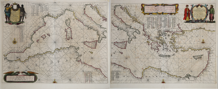
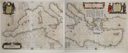
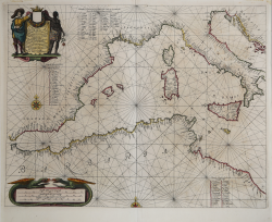
Pascaarte van't westlyckste deel vande Middelandsche-Zee: waer in vertoont wort de ware gelegenthe den van alle rivieren, haven, Capen droogte en bayen alles synde op hare streckingen en distantien geleyt = Tabula Hydrographica de partibus Occidentalioribus Maris Mediterranei In qua veri situs omnium flumium, portium, promontorium, vadorum, sinuumque secundum longitudinem suam positi exhibendi.
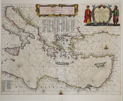
Pascaarte Van't oostelyckste deel vande Middelandsche Zee: vertonende in sich de ware gelegentheden van alle capen, havens, rivieren, bayen en droogtē, zynde alles op zyn behoorlycke streckingen en distantiē geleyt = Tabula hydrographica de partibus or Orientalioribus Maris Mediterranei. Exhibens verum situm omnium Promontorium, portium, fluminium, finuum, vadorumque secundum excatam cujusque longitudem et distantiam descriptorum.
Etching and engraving, respectively mm 420x495 e mm 420x540.
Imprint in both cartouche: Amstelodami Apud Ioan. Ianssonium.
Magnificent proofs, printed on contemporary laid paper, old colours, light foxing, generally in good condition.
Two nautical charts from Atlantis Majoris, Quinta Pars Orbem Maritimum Seu Omnium Marium totius Orbis Terrarum Navigationibus hodierno tempore frequentatorum descriptionem accuratissimam continenes; Cui adjunctus est Orbis Antiquus Et Graeciae Parallela. Sive Antiquorum & Hodiernorum locorum in Graecia collatio. Amstelodami, Apud Ioannem Janssonium. 1650.
Jansson's Atlantis Majoris was the first widely disseminated sea atlas of the world published in the Netherlands. Intended to be one of the book's in Jansson's Atlas Maior, the maps are now among the earliest obtainable sea charts of the regions covered, preceding the work of Colom, Theunisz, Lootsman, Goos, Roggeveen and Van Keulen, whose sea atlases came to dominate the market in the second half of the 17th Century.
Bibliografia: C. Koeman, Atlantes Neerlandici: Bibliography of Terrestrial, Maritime and Celestial Atlases and Pilot Books Published in the Netherlands up to 1880 Vol. II, Amsterdam 1969, pp. 492-498, Me 164 20, 22 (666, 668) - Vol. IV, Amsterdam 1970, pp. 272-275; Mare Nostrum, a historic voyage across the Mediterranean Sea, Lussemburgo, 2003, pp. 20-21; National Maritime Museum, Catalogue of the Library - Vol. Three, Atlas & Cartography, Londra, 1971, pp. 92-100, n. 102 (nn. 385, 387).
|
S. Bifolco, "Mare Nostrum, Cartografia nautica a stampa del Mar Mediterraneo" (2020), pp. 98-99, tav. 34.
|
Johannes JANSSONIUS (1588-1664)
|
Johannes Janssonius, more commonly known to us as Jan Jansson, was born in Arnhem where his father was a bookseller and publisher (Jan Janszoon the Elder). In 1612 he married the daughter of the cartographer and publisher Jodocus Hondius, and then set up in business in Amsterdam as a book publisher. In 1616 he published his first maps of France and Italy and from then onwards he produced a very large number of maps, perhaps not quite rivalling those of the Blaeu family but running a very close second in quantity and quality. From about 1630 to 1638 he was in partnership with his brother-in-law, Henricus Hondius, issuing further editions of the Mercator/Hondius atlases to which his name was added. On the death of Henricus he took over the business, expanding the atlas still further, until eventually he published an 11-volume Atlas Major on a scale similar to Blaeu's Atlas Major.
The first full edition of Jansson's English County Maps was published in 1646 but some years earlier he issued a number of British maps in the Mercator/Hondius/Jansson series of atlases (1636-44); the maps were printed from newly engraved plates and are different from the later 1646 issue and are now rarely seen (see Appendix B for further details).
In general appearance Jansson's maps are very similar to those of Blaeu and, in fact, were often copied from them, but they tend to be more flamboyant and, some think, more decorative.
After Jansson's death his heirs published a number of maps in an Atlas Contractus in 1666 and later still many of the plates of his British maps were acquired by Pieter Schenk and Gerard Valck, who published them again in 1683 as separate maps.
|
|
S. Bifolco, "Mare Nostrum, Cartografia nautica a stampa del Mar Mediterraneo" (2020), pp. 98-99, tav. 34.
|
Johannes JANSSONIUS (1588-1664)
|
Johannes Janssonius, more commonly known to us as Jan Jansson, was born in Arnhem where his father was a bookseller and publisher (Jan Janszoon the Elder). In 1612 he married the daughter of the cartographer and publisher Jodocus Hondius, and then set up in business in Amsterdam as a book publisher. In 1616 he published his first maps of France and Italy and from then onwards he produced a very large number of maps, perhaps not quite rivalling those of the Blaeu family but running a very close second in quantity and quality. From about 1630 to 1638 he was in partnership with his brother-in-law, Henricus Hondius, issuing further editions of the Mercator/Hondius atlases to which his name was added. On the death of Henricus he took over the business, expanding the atlas still further, until eventually he published an 11-volume Atlas Major on a scale similar to Blaeu's Atlas Major.
The first full edition of Jansson's English County Maps was published in 1646 but some years earlier he issued a number of British maps in the Mercator/Hondius/Jansson series of atlases (1636-44); the maps were printed from newly engraved plates and are different from the later 1646 issue and are now rarely seen (see Appendix B for further details).
In general appearance Jansson's maps are very similar to those of Blaeu and, in fact, were often copied from them, but they tend to be more flamboyant and, some think, more decorative.
After Jansson's death his heirs published a number of maps in an Atlas Contractus in 1666 and later still many of the plates of his British maps were acquired by Pieter Schenk and Gerard Valck, who published them again in 1683 as separate maps.
|