
| Reference: | VR16OL |
| Author | Hendrick DONCKER |
| Year: | 1658 |
| Zone: | Mediterranean Sea |
| Printed: | Amsterdam |
| Measures: | 540 x 440 mm |
| Reference: | VR16OL |
| Author | Hendrick DONCKER |
| Year: | 1658 |
| Zone: | Mediterranean Sea |
| Printed: | Amsterdam |
| Measures: | 540 x 440 mm |
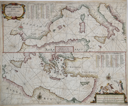
Etching and engraving, 440x540 mm, signed on plate in the cartouche at the top left.
Beautiful example of this rare Mediterranean nautical chart, in magnificent original colouring.
These is the first version of the Mediterranean map inserted in the nautical atlas by Hendrick Doncker (circa 1625 - 1699), the Zee-Atlas of Water-Waerelt (1659), the most up-to-date among the nautical atlases of the golden century of Dutch cartography. Between 1659 and 1669 Doncker progressively increased the number of charts; first from 19 to 30 and then to 50. This version of the Mediterranean map is present in the slater reprints of 1661, 62, 63 and 64 (see Koeman, IV, pp. 159-160, Don 3-7) to be replaced in 1665 from a map in two sheets of atlas - not joinable - one with the representation of the western part and the second one for the eastern part of the Mediterranean Sea.
From: De Zee-Atlas Ofte Water-Waereld, Vertoonende all de Zee-kusten Van het bekende Deel des Aerd-Bodems, Met een generale beschryvinge van dien. Seer dienstigh voor alle Schippers en Stuurlieden; mitsgaders Koop-lieden om op ‘t Kantoor gebruykt te werden. Nieuwelijks aldus uytgegeven. t’ Amsterdam, By Hendrick Doncker, Boekveerkooper, en Graat-boog-maker, in dee Nieuwe-brug-steeg, in ‘t Stuur-mans Gereetschap. Anno. 1660.
Bibliografia: C. Koeman, Atlantes Neerlandici: Bibliography of Terrestrial, Maritime and Celestial Atlases and Pilot Books Published in the Netherlands up to 1880 Vol. IV, Amsterdam 1970, pp. 152-189, Don 2 (8); National Maritime Museum, Catalogue of the Library - Vol. Three, Atlas & Cartography, Londra, 1971, p. 75, n. 84 (14); cfr. R. Shirley, Maps in the Atlases of the British Library, Londra, 2004, pp. 1161-1163.
|
S. Bifolco, "Mare Nostrum, Cartografia nautica a stampa del Mar Mediterraneo" (2020), pp. 106-107, tav. 39.
|
|
For about fifty years Hendrick Doncker ran a flourishing business in Amsterdam as a bookseller and publisher of sea atlases and textbooks on navigation.
In a period when so many maps and charts were simply copied from other publishers, Doncker's charts were his own work and were noted for their accuracy and constant improvement.
Apart from this work, he cooperated for many years with Pieter Goos and Anthonie Jacobsz in producing a pilot guide De Zeespiegel. Eventually his stock was sold to Johannes van Keulen.
|
|
S. Bifolco, "Mare Nostrum, Cartografia nautica a stampa del Mar Mediterraneo" (2020), pp. 106-107, tav. 39.
|
|
For about fifty years Hendrick Doncker ran a flourishing business in Amsterdam as a bookseller and publisher of sea atlases and textbooks on navigation.
In a period when so many maps and charts were simply copied from other publishers, Doncker's charts were his own work and were noted for their accuracy and constant improvement.
Apart from this work, he cooperated for many years with Pieter Goos and Anthonie Jacobsz in producing a pilot guide De Zeespiegel. Eventually his stock was sold to Johannes van Keulen.
|