| Reference: | s35026 |
| Author | Francesco Maria LEVANTO |
| Year: | 1697 |
| Zone: | Mediterranean sea |
| Printed: | Venice |
| Measures: | - x - mm |
| Reference: | s35026 |
| Author | Francesco Maria LEVANTO |
| Year: | 1697 |
| Zone: | Mediterranean sea |
| Printed: | Venice |
| Measures: | - x - mm |
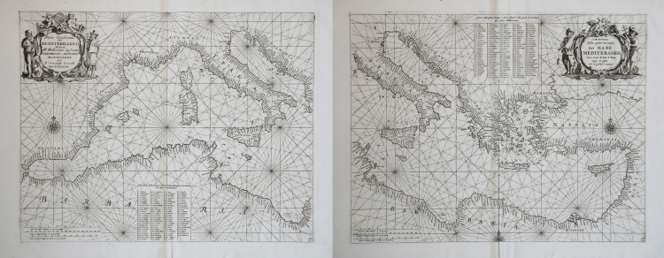
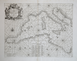
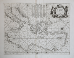
Two large maps of Mediterranea sea - one for the western area and one for the eastern area, prepared in the Portolano style, by Francesco Maria Levanto, in the edition by Vincenzo Maria Coronelli.
The two Levanto's maps, were published in his "Lo Specchio del Mare" (The Mirror of the Sea) the portolan atlas of Mediterranean published in its first edition in Genoa in 1664 ,and the second edition in 1679.
Despite the atlas didn't has a great success at the time, perhaps because it was recognized as unoriginal by contemporary cartographers, Coronelli - who almost certainly did not know the model and the Nordic plates - wanted to include the atlas as the last volume in the 1698 edition of his Atlante Veneto.
The cartouche of the western part bears the dedicated to Count Fabrizio Antonio Monsignani, a member of the Academy of Filergiti.
Each plater, consisting of two sheets joined together, measuring 510 x 402 mm.
Magnificient examples, in perfect condition.
|
S. Bifolco, "Mare Nostrum, Cartografia nautica a stampa del Mar Mediterraneo" (2020), pp. 50-51, tav. 14.
|
Francesco Maria LEVANTO (Attivo intorno al 1664)
|
Following the footmark treaced by the colonial conquests and inside the great chart production the West India Company promoted, a lot very specific Atlases for sailors have been realized in Holland; some of them described the North Sea, or the Atlantic Sea or the whole world (H. Doncker, De Zee-Atlas, 1659; P. Goos, De Zee-Spiegel, 1650), few of them were about the Mediterranean Sea ( J.A. Colom, Colom de la Mer Mediterrannée, 1644). At the same time, in Italy, some publishers started to print Italian sea charts (Robert Dudley, Dell'arcano del mare, 1647). We have then to consider Levanto’s work inside this contest, for it was a very accurate and detailed one. To better understand the effort he put in this work, we must read the dedication “Al lettore” (To the reader), where it is said that the author has a great "prattica di passa 20 anni di navigatione" (20 years experience as a sailor) which he wants now to share with others through the moaning of the press. Apart from being the first Italian sea Atlas, entirely dedicated to the Mediterranean Sea, this is also a typographical masterpiece, due to all the xylographies and engraved big-size charts. In the XVI century, in fact, Italy was characterized by the realization of refined maps, apart from literary works or scientific branches of learning, which of course were enhanced by the clearness of the iconographic adornment, made up by the beautiful sea charts.
1664 First part of the Specchio del Mare
|
|
S. Bifolco, "Mare Nostrum, Cartografia nautica a stampa del Mar Mediterraneo" (2020), pp. 50-51, tav. 14.
|
Francesco Maria LEVANTO (Attivo intorno al 1664)
|
Following the footmark treaced by the colonial conquests and inside the great chart production the West India Company promoted, a lot very specific Atlases for sailors have been realized in Holland; some of them described the North Sea, or the Atlantic Sea or the whole world (H. Doncker, De Zee-Atlas, 1659; P. Goos, De Zee-Spiegel, 1650), few of them were about the Mediterranean Sea ( J.A. Colom, Colom de la Mer Mediterrannée, 1644). At the same time, in Italy, some publishers started to print Italian sea charts (Robert Dudley, Dell'arcano del mare, 1647). We have then to consider Levanto’s work inside this contest, for it was a very accurate and detailed one. To better understand the effort he put in this work, we must read the dedication “Al lettore” (To the reader), where it is said that the author has a great "prattica di passa 20 anni di navigatione" (20 years experience as a sailor) which he wants now to share with others through the moaning of the press. Apart from being the first Italian sea Atlas, entirely dedicated to the Mediterranean Sea, this is also a typographical masterpiece, due to all the xylographies and engraved big-size charts. In the XVI century, in fact, Italy was characterized by the realization of refined maps, apart from literary works or scientific branches of learning, which of course were enhanced by the clearness of the iconographic adornment, made up by the beautiful sea charts.
1664 First part of the Specchio del Mare
|