| Reference: | S36875 |
| Author | Anonimo |
| Year: | 1600 ca. |
| Zone: | Rome |
| Printed: | Rome |
| Measures: | 524 x 400 mm |
| Reference: | S36875 |
| Author | Anonimo |
| Year: | 1600 ca. |
| Zone: | Rome |
| Printed: | Rome |
| Measures: | 524 x 400 mm |
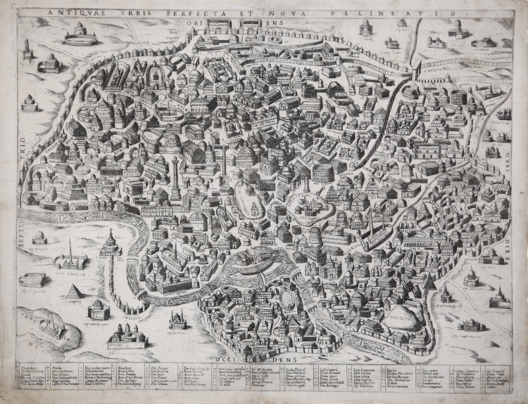
Archaeological map with vertical projection with elevation, without date and printing details. It is a faithful replica of the map published by Nicolas van Aelst and engraved by Ambrogio Brambilla, probably published in Rome between the end of the 16th century and the beginning of the following century. Caldana underlines that "the anonymous engraver is almost as good as the author of the original, the differences are minimal, except for the measurements that in the copy are slightly smaller; even the calligraphy of the place names is imitated, less so for some, written in capital letters".
From the editorial point of view, the existence of a copy with the imprint of Gian Giacomo de Rossi, described by Hülsen (1933) in the collection of Wolfegg Castle, certifies that the copper was in the possession of the Roman printing house. Caldana also maintains, but without foundation, that the map was engraved by Giuseppe de Rossi in 1637, on the occasion of the reprinting of the modern Rome map. We believe instead that the copper is older and that, as for many plates of the previous century, it was only later acquired by de Rossi's printing house.
At the top, along the upper edge, is engraved the title: ANTIQUAE URBIS PERFECTA ET NOVA DELINEATIO. Along the lower margin there is a numerical legend of 90 references to notable places and monuments distributed on fifteen columns. Orientation on the four sides in the centre with the name of the cardinal points: SEPTENTRIO, MERIDIES, OCCIDENS, ORIENS the north is on the left. In the map there are further toponymic indications.
Etching and engraving; exemple in the first state of two, before the De Rossi's address. Magnificent example of this rare archaeological map of Rome. In perfect state of conservation.
Literature
Bifolco-Ronca, Cartografia e topografia italiana del XVI secolo, p. 2368, tav. 1217, I/II; Caldana (2013): n. I.28; Hülsen (1915): pp. 55-56, VIIIc, n. 41; Hülsen (1933): p. 106, VIIIc, n. 41a; Scaccia Scarafoni (1939): p. 28, n. 24.
Anonimo
Anonimo